© Stephen Burt
St. Austell Bay, Cornwall, United Kingdom of Great Britain and Northern Ireland
Latitude: 50° 18' 45'' N
Longitude: 4° 46' 23'' W
11 August 2009 1341 (Local Time)
Camera direction: towards SE
Image P/S code: P.9.1
Image I.D.: 2635
CL = 1, CM = 0, CH = 0
-
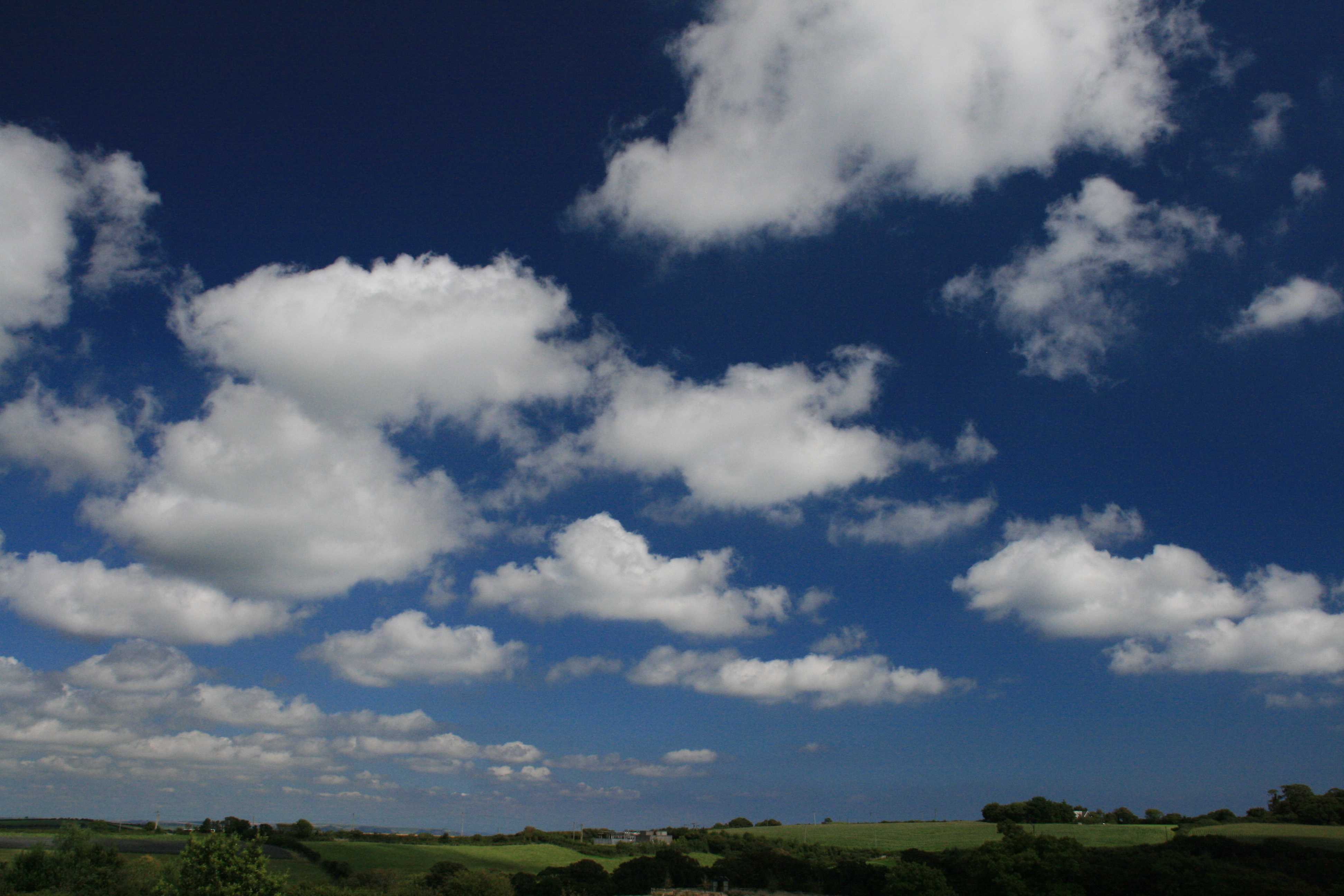
Cumulus humilis
This photograph shows detached Cumulus clouds of small vertical extent. They are white with outlines that are generally not very ragged and have relatively clear-cut horizontal bases, such as at 1 and 2. Viewed from a distance, the clouds as a whole appear as if flattened or deflated, defining them as species humilis. Some may have rounded tops, as seen near the centre of the image, but without a cauliflower appearance. Cumulus humilis clouds never give precipitation. Towards the top of the image, the ragged and indistinct edges of the cloud identify the species as fractus, most likely in the process of developing into humilis.
Links in the image description will highlight features on the image. Mouse over the features for more detail.
© Stephen BurtSt. Austell Bay, Cornwall, United Kingdom of Great Britain and Northern IrelandLatitude: 50° 18' 45'' NLongitude: 4° 46' 23'' W11 August 2009 1341 (Local Time)Camera direction: towards SECL = 1, CM = 0, CH = 0Image P/S code: P.9.1Image I.D.: 2635
At 1200 UTC, an anticyclone of 1 028 hPa centred near the Azores, Portugal extended a weak ridge across southern Britain (including the location of the photograph) into the North Sea.
© Deutscher Wetterdienst
The 1200 UTC sounding from the nearby station Camborne, England, UK (WMO 03808) shows a strong subsidence inversion at approximately 900 hPa/1 000 m above the surface. The air above 900 hPa is very dry, confining any cloud to the boundary layer. The estimated cloud base was 750 m, suggesting a depth of cloud of only 150 to 250 m.
© University of Wyoming
In this visual satellite image, the shallow Cumulus can be seen over the south-west of England. The time of the satellite image and that of the photograph are almost identical.
© NEODAAS/University of Dundee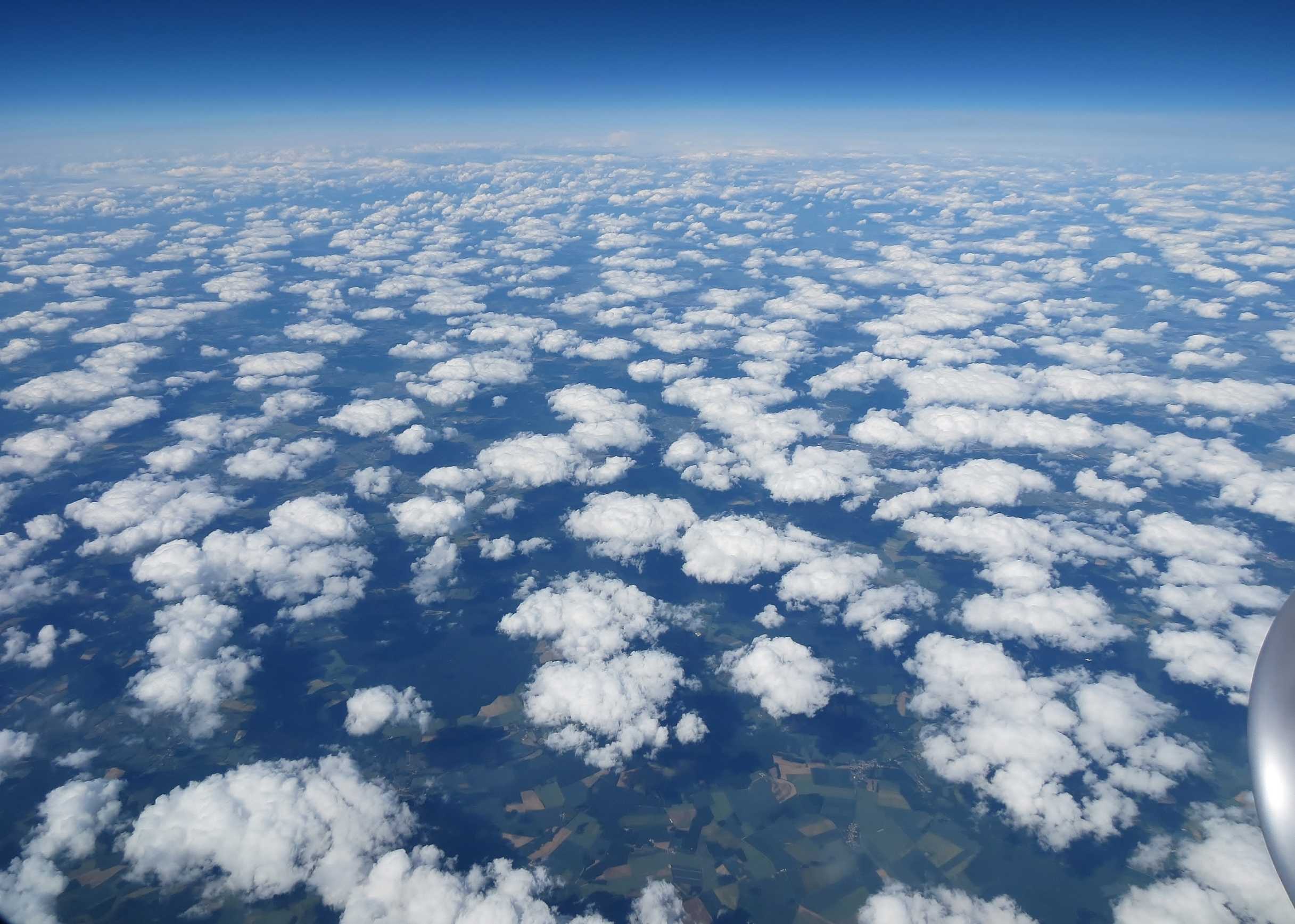
Cumulus humilis
The aerial image shows Cumulus cloud from above. The cloud elements are generally dense but in a relatively random pattern. There is only limited vertical development with a generally flattened appearance to the cloud, indicative of the species humilis (CL = 1). The reported cloud base was 5 000 ft and the cloud tops were estimated at approximately 6 000 ft. The surface data were taken from Charles de Gaulle Airport, Paris, France observations.
Links in the image description will highlight features on the image. Mouse over the features for more detail.
© Frank Le Blancqnorthern FranceLatitude: 49° 15' 56'' NLongitude: 3° 12' 5'' E05 June 2014 1648 (Local Time)Camera direction: towards NEImage P/S code: S.9.1 2Image I.D.: 4984
Cumulus humilis
The image shows detached Cumulus clouds of small vertical extent; the sunlit parts are white and the bases are darker. They have relatively sharp outlines with clear-cut horizontal bases. The clouds as a whole appear as if flattened or deflated, defining them as the species humilis. Some may have rounded tops, but without a cauliflower appearance. Cumulus humilis cloud never gives precipitation. There are a few ragged and indistinct edges, which identify the species as fractus, most likely in the process of developing into humilis.
Links in the image description will highlight features on the image. Mouse over the features for more detail.
© Stefan KämpfeWeimar, GermanyLatitude: 51° 0' 32'' NLongitude: 11° 18' 33'' E17 June 2011 1530 (Local Time)Camera direction: towards NECL = 1, CM = 0, CH = 0Image P/S code: S.9.1 1Image I.D.: 4985

Formation of Cumulus humilis and fractus
This time-lapse video shows the initial formation of Cumulus fractus and Cumulus humilis clouds from a clear sky, in response to the heating of the ground by the Sun during the morning. The time lapse covers a period of 28 minutes.
A ridge of high pressure covered southern England, UK and the morning began with clear skies. The air temperature (at 1.3 m) overnight had fallen to 1 °C and the temperature over grass had fallen to –4 °C. In response to solar heating, the temperature over the grass surface had risen to above 20 °C by the time of the video in the mid-morning and the air temperature was 9 °C. The lowest level of the atmosphere was unstable to these temperatures and rising thermals began to form Cumulus clouds. In this initial stage of development, the clouds were of the species fractus and humilis.
Links in the image description will highlight features on the image. Mouse over the features for more detail.
© George AndersonWokingham, England, United Kingdom of Great Britain and Northern IrelandLatitude: 51° 25' 5'' NLongitude: 0° 51' 49'' W27 April 2015 1021 (Local Time)Camera direction: towards NWCL = 1, CM = 0, CH = 0Image P/S code: S.9.1 2Image I.D.: Array
Cumulis humilis and Cirrostratus
This Cumulus humilis and fractus followed the cessation of daytime convective cloud within the north-east trades region in the Caribbean. Grand Anse Beach, Grenada at 1811 local time on 26 Sept 1978.
Links in the image description will highlight features on the image. Mouse over the features for more detail.
© Stephen BurtGrenadaLatitude: 12° 0' 6'' NLongitude: 61° 47' 46'' W26 September 1978 1811 (Local Time)Camera direction: towards WCL = 1, CM = 0, CH = 8Image P/S code: S.9.1 20Image I.D.: 5001
Cumulus humilis and Altocumulus stratiformis translucidus perlucidus
Cumulus are detached clouds, generally dense and with sharp outlines, that develop vertically in the form of rising mounds, domes or towers. Sunlit parts are mostly brilliant white. This photograph shows an excellent example of Cumulus humilis clouds, which have very limited vertical extent, clear-cut horizontal bases and a generally flattened appearance that is typical of the species. Above the Cumulus we see a distinct layer of Altocumulus (species stratiformis) and as it is semi-transparent, we may define the variety as translucidus. Where spaces between the cloud elements are sufficient to see blue sky, we see the variety perlucidus. The image as a whole is a good example of the height difference between cloud in the low and middle levels.
Links in the image description will highlight features on the image. Mouse over the features for more detail.
© Stefan KämpfeWeimar, Thuringia, GermanyLatitude: 51° 0' 57'' NLongitude: 11° 18' 53'' E17 June 2011 1600 (Local Time)Camera direction: towards NECL = 1, CM = 3, CH = 0Image P/S code: S.9.1 4Image I.D.: 5117
Cumulus humilis
Cumulus are detached clouds, generally dense and with sharp outlines, that develop vertically in the form of rising mounds, domes or towers. The photograph shows small Cumulus clouds of very limited vertical development with clear-cut horizontal bases and a generally flattened appearance this is typical of the species humilis. The measured base of 1 300 m and estimated cloud top of 1 500 m confirm a shallow depth of less than 300 m. Cumulus are normally white, but this image was taken a few minutes before sunset; therefore, due to the low angle of the Sun, the upper parts of the clouds (still in sunlight) have a pink tinge, while the bases are dark. Cumulus humilis clouds never give precipitation.
Links in the image description will highlight features on the image. Mouse over the features for more detail.
© Frank Le BlancqJersey Airport, St Peter, JerseyLatitude: 49° 12' 25'' NLongitude: 2° 11' 52'' W20 October 2010 1857 (Local Time)Camera direction: towards NECL = 1, CM = 0, CH = 0Image P/S code: S.9.1 3Image I.D.: 5526
Cumulis humilis and fractus
Cumulus are detached clouds, generally dense and with sharp outlines, that develop vertically in the form of rising mounds, domes or towers, with mostly brilliant white sunlit parts. As seen in this photograph, Cumulus humilis is characterized by having little vertical extent, and appears generally as if flattened. Cumulus humilis clouds never give precipitation. Also visible in the image is Cumulus fractus – small clouds with ragged edges and outlines that are continuously undergoing changes. This Cumulus fractus of fine weather is the initial stage in the development of Cumulus humilis.
Links in the image description will highlight features on the image. Mouse over the features for more detail.
© Michael BruhnMelbourne Airport, Victoria, AustraliaLatitude: 37° 40' 39'' SLongitude: 144° 50' 7'' E19 October 2012 1020 (Local Time)Camera direction: towards SWCL = 1, CM = 0, CH = 0Image P/S code: S.9.1 5Image I.D.: 5941
Cumulus Humilis
A field of Cumulus humilis fills the sky at midday over the elevated dry plateau surrounding the Grand Canyon. All of the tops are flat or are only very small and rounded at 2 and 3. Clear-cut horizontal bases are present everywhere. A few Cirrus fibratus streaks are visible at 4 and 5. The Cumulus clouds began to form during the morning on an undisturbed dry day dominated by the diurnal cycle of heating. Only a few isolated Cumulonimbi formed toward sunset.
Links in the image description will highlight features on the image. Mouse over the features for more detail.
© R.L. HolleGrand Canyon, Arizona, United States of AmericaLatitude: 36° 6' 25'' NLongitude: 112° 6' 47'' W18 August 1977 1240 (Local Time)Camera direction: towards ECL = 1, CM = 0, CH = 1
Cumulus humilis with haze
These Cumulus clouds are scattered; most of them are fairly dense masses with definite horizontal bases. Their vertical extent is small and they are consequently of the species humilis. In the vicinity of the main clouds there are some isolated fragments at 1 and 2. Haze veils the distant units.
The station was in old maritime polar air on the south-western margin of a cold upper low centred over the northern part of the Federal Republic of Germany, but far from any front and in a zone of weak surface pressure gradients. The winds at the surface were light N to NE, turning to NW aloft.
Links in the image description will highlight features on the image. Mouse over the features for more detail.
© A. ViautParis, FranceLatitude: 48° 51' 1'' NLongitude: 2° 18' 26'' E28 April 1952 1305 (Local Time)Camera direction: towards NECL = 1, CM = 0, CH = 0