© Stephen Burt
سترتفيلد مورتيمر، بالقرب من ريدنغ، باركشير RG7، إنكلترا، المملكة المتحدة لبريطانيا العظمى وأيرلندا الشمالية
خط العرض: 51° 22' 12'' N
خط الطول: 1° 2' 24'' W
10 July 2010 2040 (التوقيت المحلي)
رمز الصورة P/S: P.4.12
محدد هوية الصورة: 5925
CL = 0, CM = 8, CH = 0
-
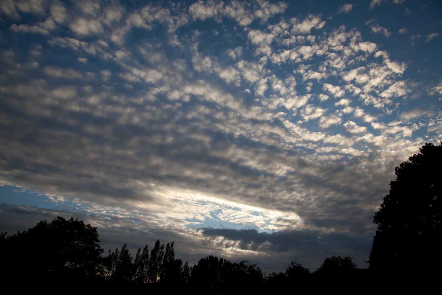
الركام الأعلى المخصّل المزدوج الإشعاعي الغازي
هذه هي الحافة الأمامية لحزام مكوّن من طبقتين من الركام الأعلى الغازي الذي سرعان ما زاد سمكه وكميته.
والطبقة السفلية من الركام الأعلى ضاربة إلى اللون الرمادي الداكن (فوق الأشجار) وتتكون من خصلات متراكبة التشكيل ذات قواعد واضحة المعالم في معظم أجزائها. وإلى يسار هذه الخصلات، تتبدد القواعد وتصبح مهلهلة.
والطبقة الأعلى ضاربة إلى اللون الرمادي الفاتح وبيضاء في الأجزاء الأقل سمكاً. وتُدمج العناصر في هذه الطبقة في صورة صفوف طويلة تبدو كما لو أنها تتلاقى نحو نقطة بالقرب من الأفق. وهذا ما يمثل الصنف الإشعاعي.
الروابط الموجود في وصف الصورة ستظهر خصائص الصورة. ولمزيد من التفاصيل يلزم تمرير مؤشر الفأرة على الصورة.
© Stephen Burtسترتفيلد مورتيمر، بالقرب من ريدنغ، باركشير RG7، إنكلترا، المملكة المتحدة لبريطانيا العظمى وأيرلندا الشماليةخط العرض: 51° 22' 12'' Nخط الطول: 1° 2' 24'' W10 July 2010 2040 (التوقيت المحلي)CL = 0, CM = 8, CH = 0رمز الصورة P/S: P.4.12محدد هوية الصورة: 5925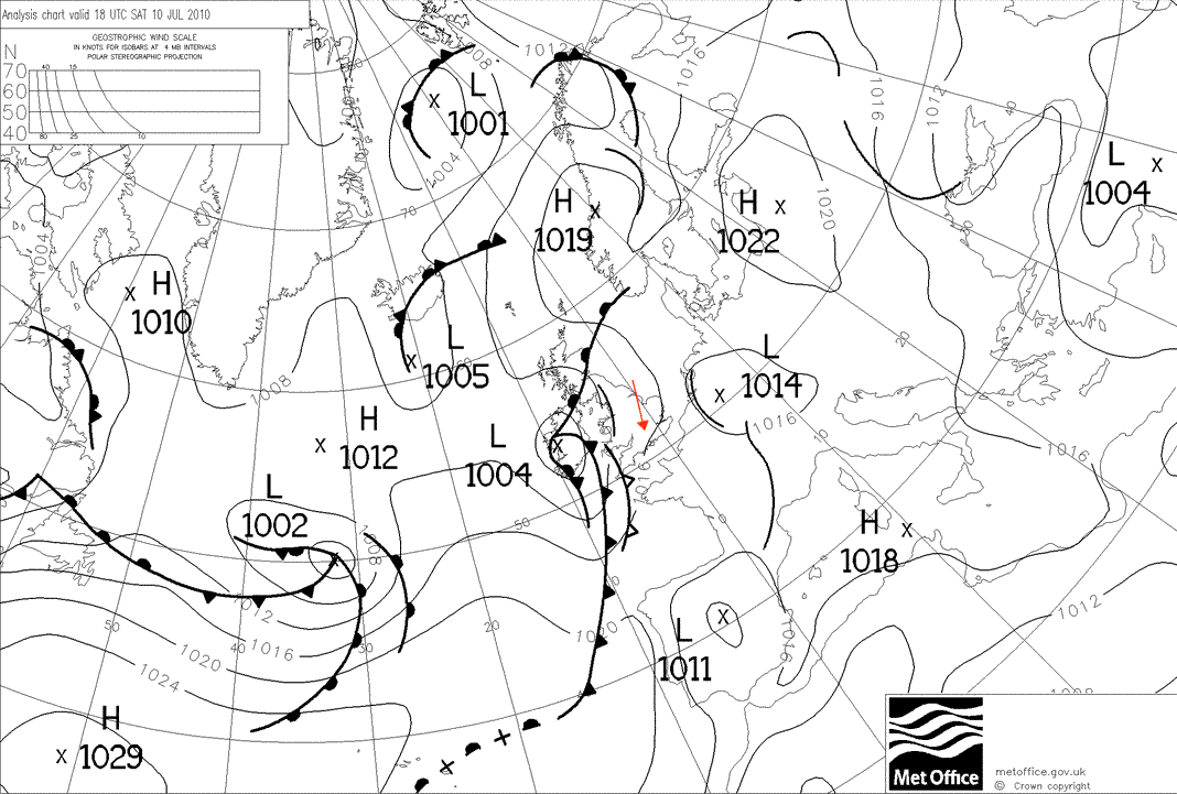
كان هناك منخفض ضحل مفتوح الموجة يتكون غرب الجزر البريطانية حيث التُقطت هذه الصورة، على مقربة من موجة أخرى تتطور فوق شرق فرنسا.
© تاج حقوق التأليف والنشر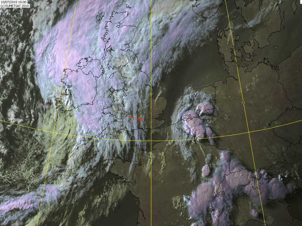
يمكن رؤية السمحاق الذي سبق الركام الأعلى شرق سترتفيلد مورتيمر، إنكلترا، المملكة المتحدة. وتقع الحافة الأمامية للركام الأعلى الغازي على بعد 50 كم إلى الغرب.
© المنظمة الأوروبية لاستخدام السواتل الخاصة بالأرصاد الجوية، 2010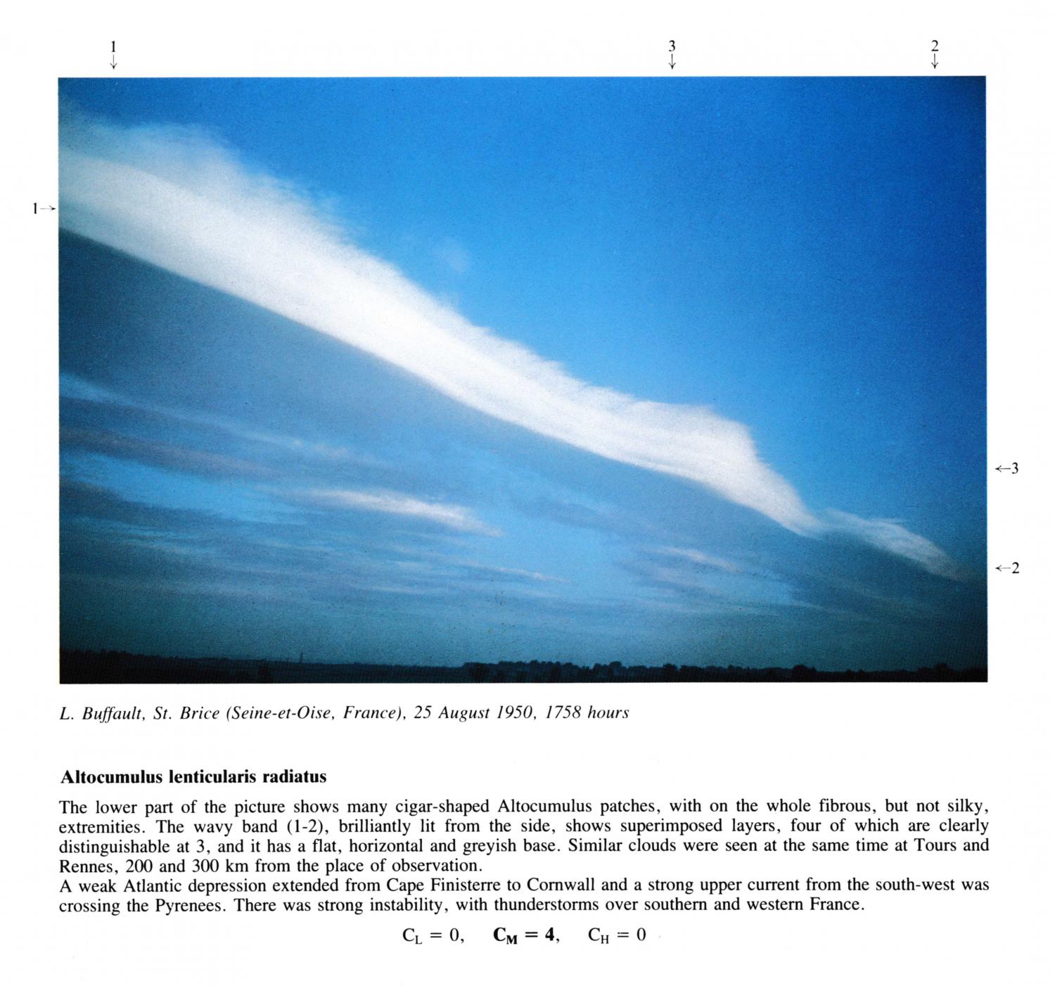
Altocumulus lenticularis radiatus
The lower part of the picture shows many cigar-shaped Altocumulus patches, with on the whole fibrous, but not silky, extremities. The wavy band (1 - 2), brilliantly lit from the side, shows superimposed layers, four of which are clearly distinguishable at 3, and it has a flat, horizontal and greyish base. Similar clouds were seen at the same time at Tours and Rennes, 200 and 300 km from the place of observation. A weak Atlantic depression extended from Cape Finisterre to Cornwall and a strong upper current from the south-west was crossing the Pyrenees. There was strong instability, with thunderstorms over southern and western France.
الروابط الموجود في وصف الصورة ستظهر خصائص الصورة. ولمزيد من التفاصيل يلزم تمرير مؤشر الفأرة على الصورة.
© L. BuffaultSaint-Brice-sous-Forêt, Seine-et-Oise, Franceخط العرض: 48° 59' 58'' Nخط الطول: 2° 21' 22'' E25 August 1950 1758 (التوقيت المحلي)CL = 0, CM = 4, CH = 0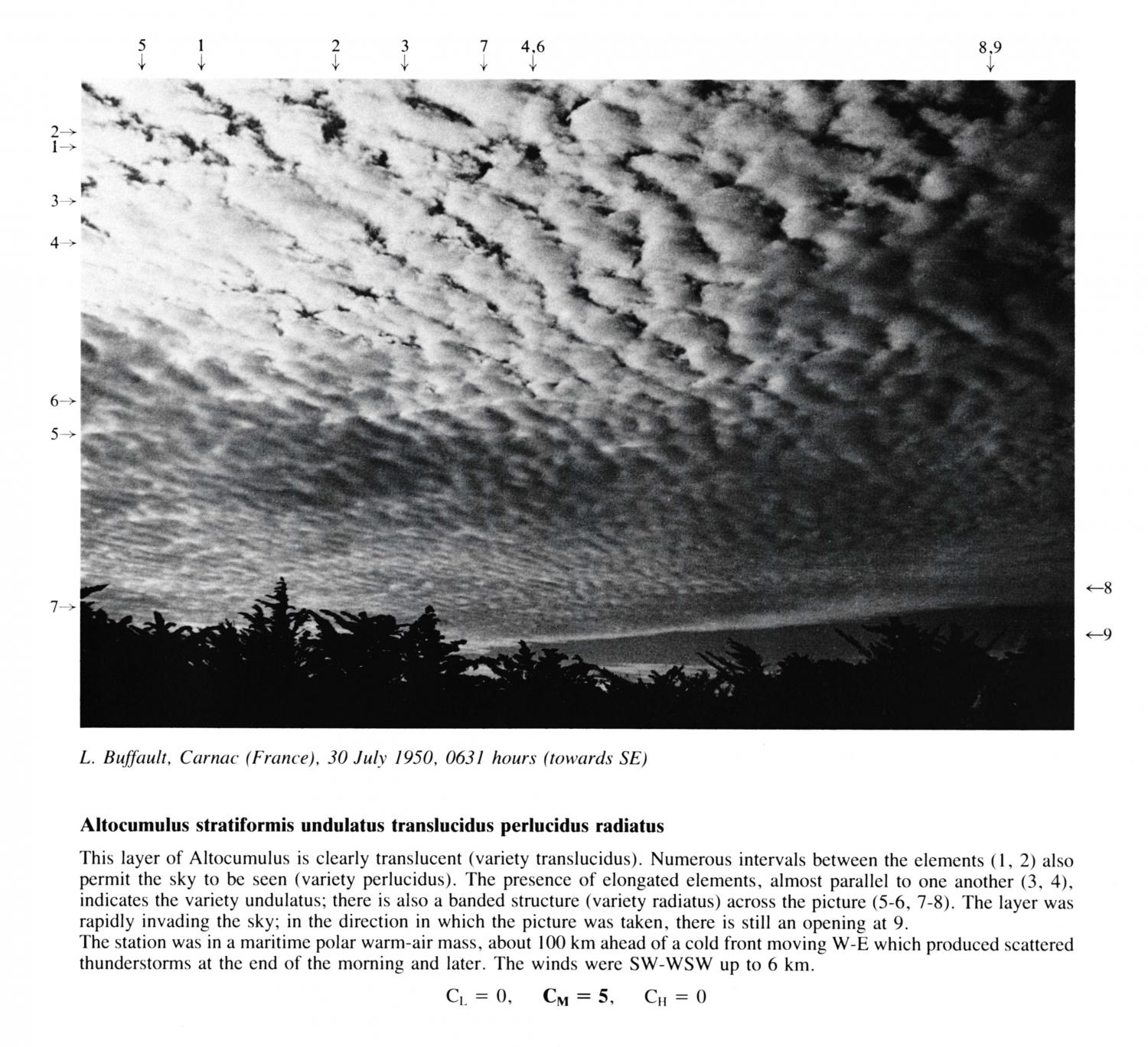
Altocumulus stratiformis undulatus translucidus perlucidus radiatus
This layer of Altocumulus is clearly translucent (variety translucidus). Numerous intervals between the elements 1 and 2 also permit the sky to be seen (variety perlucidus). The presence of elongated elements, almost parallel to one another at 3 and 4, indicates the variety undulatus; there is also a banded structure (variety radiatus) across the picture at 5, 6, 7 and 8. The layer was rapidly invading the sky; in the direction in which the picture was taken, there is still an opening at 9. The station was in a maritime polar warm-air mass, about 100 km ahead of a cold front moving W-E which produced scattered thunderstorms at the end of the morning and later. The winds were SW-WSW up to 6 km.
الروابط الموجود في وصف الصورة ستظهر خصائص الصورة. ولمزيد من التفاصيل يلزم تمرير مؤشر الفأرة على الصورة.
© L. BuffaultCarnac, Franceخط العرض: 47° 35' 5'' Nخط الطول: 3° 4' 40'' W30 July 1950 0631 (التوقيت المحلي)CL = 0, CM = 5, CH = 0