© George Anderson
Wokingham, England, United Kingdom of Great Britain and Northern Ireland
Latitude: 51° 25' 4'' N
Longitude: 0° 51' 48'' W
17 July 2013 1727 (Local Time)
Camera direction: towards W
Image P/S code: P.13.11.4.2
Image I.D.: 4071
-

Crepuscular rays
Although the term “Crepuscular rays” normally refers to dark bluish streaks and light beams observed radiating from the Sun across the twilight sky, the name is also used to refer to the shadowed bands and light beams which diverge from the Sun when it is hidden behind cloud (usually Cumulus or Cumulonimbus) at any time of day. Sunbeams penetrating through gaps in a layer of cloud and rendered visible by water or dust particles in the air may also be referred to as crepuscular rays.
The most striking feature in this photograph, taken during a summer evening at Wokingham, UK, is the appearance of the bluish shadows cast across the sunlit sky by a large Cumulus congestus cloud. The lines accentuating these shadows and the bright sunbeams are actually parallel, but appear to radiate from the position of the Sun, which is located behind the cloud.
Cumulus congestus and Cumulonimbus clouds formed during the early evening as a result of daytime maximum temperature and low-level convergence caused by the inland penetration of a sea breeze. Thunder was heard later in the evening.
Links in the image description will highlight features on the image. Mouse over the features for more detail.
© George AndersonWokingham, England, United Kingdom of Great Britain and Northern IrelandLatitude: 51° 25' 4'' NLongitude: 0° 51' 48'' W17 July 2013 1727 (Local Time)Camera direction: towards WImage P/S code: P.13.11.4.2Image I.D.: 4071
Solar corona and crepuscular rays
The coloured rings seen around the Sun in this picture form a corona. The corona is caused by the diffraction of sunlight through thin cloud composed of very small water or ice particles. Much of the cloud here is very thin and almost invisible when viewed against the glare of the sun, but some patches of Cumulus fractus are clearly visible. Shadows from the masts on the summit of Mt. Zugspitze, Wetterstein Mountains, Germany (2 963 m) are rendered visible against the thin cloud as crepuscular rays.
Links in the image description will highlight features on the image. Mouse over the features for more detail.
© Claudia HinzMt. Zugspitze, Wetterstein Mountains, GermanyLatitude: 47° 25' 16'' NLongitude: 10° 59' 18'' E08 May 2013 1313 (Local Time)Camera direction: towards SImage P/S code: P.13.2.1Image I.D.: 4176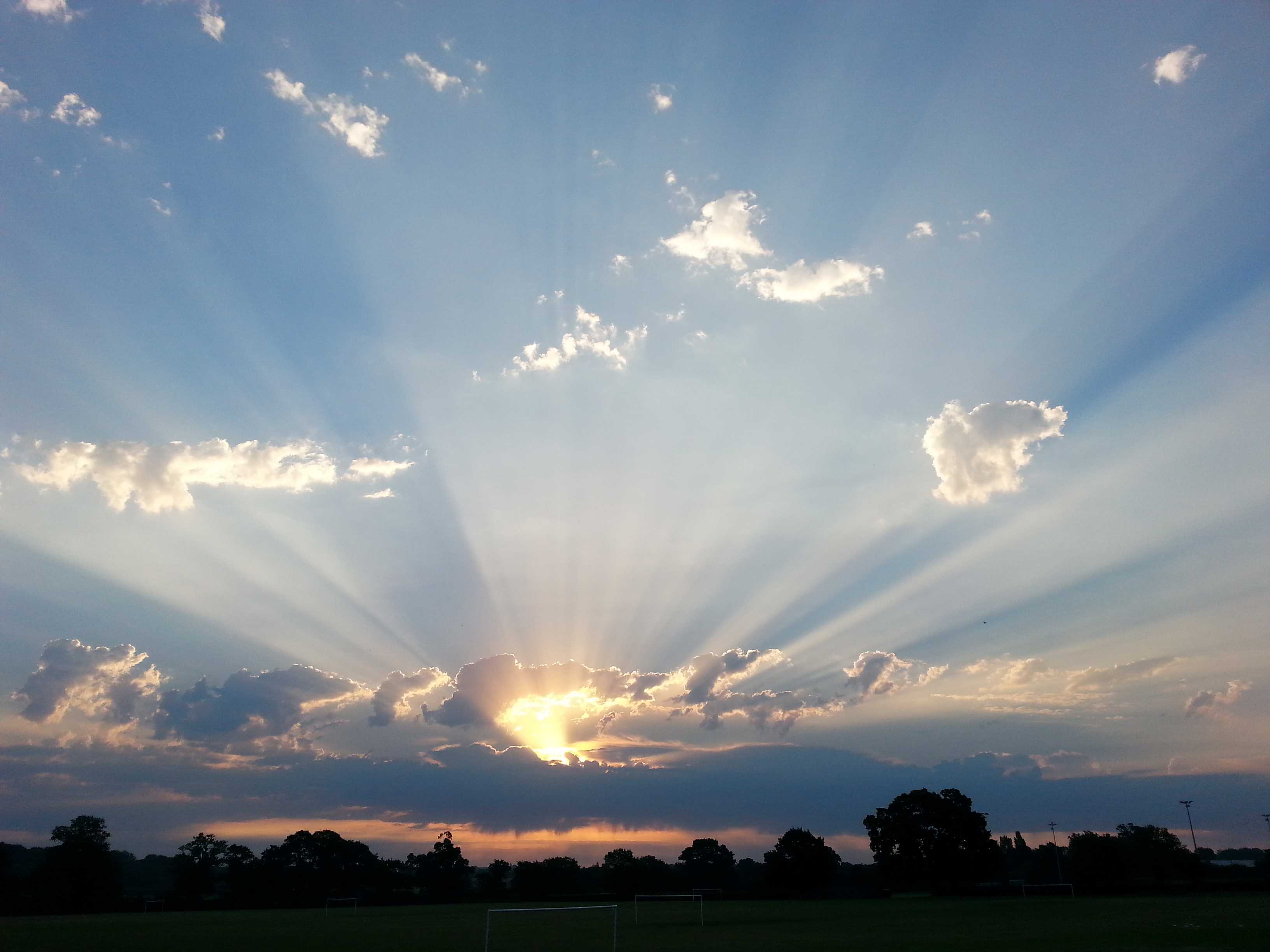
Crepuscular rays and Altocumulus castellanus and Altocumulus floccus
Crepuscular rays at 1 and 2 emanate from the rising Sun behind Altocumulus cloud in this picture from Wokingham in southern England, UK.
The term “crepuscular rays” normally refers to dark bluish streaks and light beams observed radiating from the Sun across the twilight sky. However, the name can also be used to refer to the shadowed bands and light beams which diverge from the Sun at any time of day when it is hidden behind cloud.
In the top half of the photograph, the species of Altocumulus is floccus at 3 and 4. Just above the level of the Sun is a line of Altocumulus floccus, evolved from castellanus as the latter have lost a common base. The floccus elements are being sheared toward the north-east by the upper level south-westerly winds. Below the level of the Sun is a solid line of Altocumulus castellanus, from which virga can be seen falling beneath the cloud base. Many different stages of vertical development can be seen in the turreted tops of this line.
Observations from nearby weather stations and upper air soundings put the cloud base at 14 000 ft.
Links in the image description will highlight features on the image. Mouse over the features for more detail.
© George AndersonWokingham, England, United Kingdom of Great Britain and Northern IrelandLatitude: 51° 25' 16'' NLongitude: 0° 50' 23'' W01 July 2015 0535 (Local Time)Camera direction: towards NECL = 0, CM = 8, CH = 0Image P/S code: S.13.11.4.2Image I.D.: 4704
Crepuscular rays cast by Cumulus congestus
Although the term “Crepuscular rays” normally refers to dark bluish streaks and light beams observed radiating from the Sun across the twilight sky, the name is also used to refer to the shadowed bands and light beams which diverge from the Sun at any time of day when it is hidden behind cloud (usually Cumulus or Cumulonimbus).
In this photograph from Hong Kong (China), crepuscular rays are cast across the sky by Cumulus congestus clouds. The lines accentuating these cloud shadows and bright sunbeams are actually parallel, but appear to radiate from the position of the Sun, located behind the cloud.
An accessory cloud known as pileus can be seen above one of the rising Cumulus congestus towers.
Links in the image description will highlight features on the image. Mouse over the features for more detail.
© Kam Hoo ManYuen Long, Hong Kong, ChinaLatitude: 22° 26' 40'' NLongitude: 114° 1' 20'' E17 June 2015 1906 (Local Time)CL = 0, CM = 8, CH = 0Image P/S code: S.13.11.4.2Image I.D.: 4904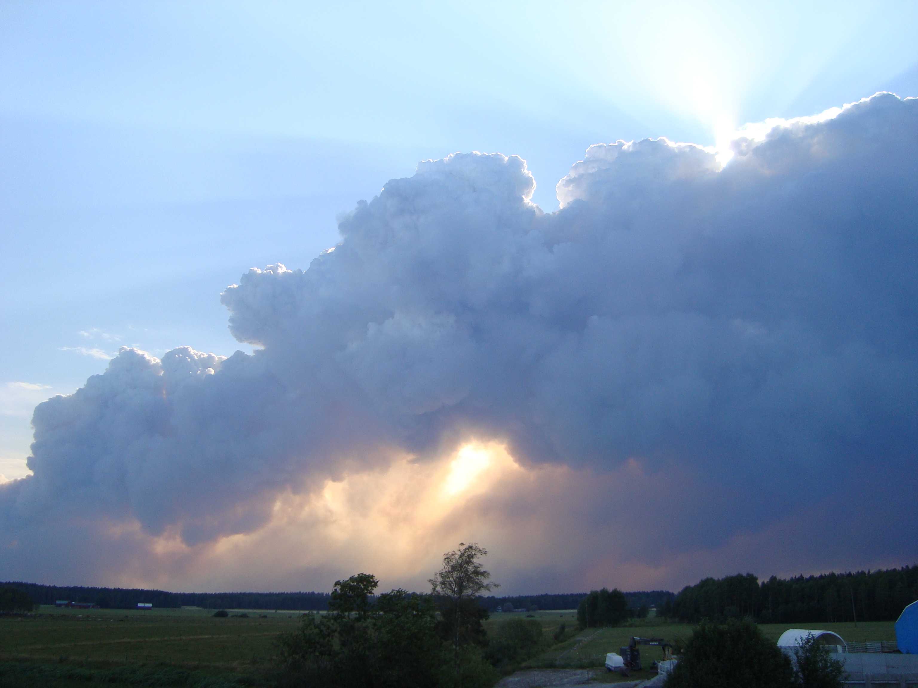
Cumulus congestus flammagenitus
This cloud is Cumulus congestus flammagenitus, formed by the largest forest fire in history in Sweden.
The term flammagenitus refers to the cloud originating as a consequence of convective currents rising from the heat of a wildfire. The species is identified as congestus by its relatively large extent and bulging upper parts that resemble a cauliflower (1 and 2).
The cloud appears dark, in part because the cloud droplets are mixed with particulate matter resulting from combustion, and in part because the Sun is behind it. Note the crepuscular rays (3 and 4) across much of the sky, rendered visible by smoke haze in the atmosphere. The rays diverge from the position of the Sun behind the cloud.
The cloud is being blown away from the heat source by a moderate south-easterly breeze.
Links in the image description will highlight features on the image. Mouse over the features for more detail.
© Hans ÖstlundAvesta SV, SwedenLatitude: 60° 5' 46'' NLongitude: 16° 18' 8'' E04 August 2014 1728 (Local Time)Camera direction: towards SWCL = 2, CM = 0, CH = 0Image P/S code: S.9.16 1Image I.D.: 4963