© George Anderson
Kivides, Cyprus
Latitude: 34° 45' 41'' N
Longitude: 32° 50' 41'' E
06 August 2007 1708 (Local Time)
Camera direction: towards NNE
Image P/S code: S.9.16
Image I.D.: 4834
CL = 2, CM = 0, CH = 0
-
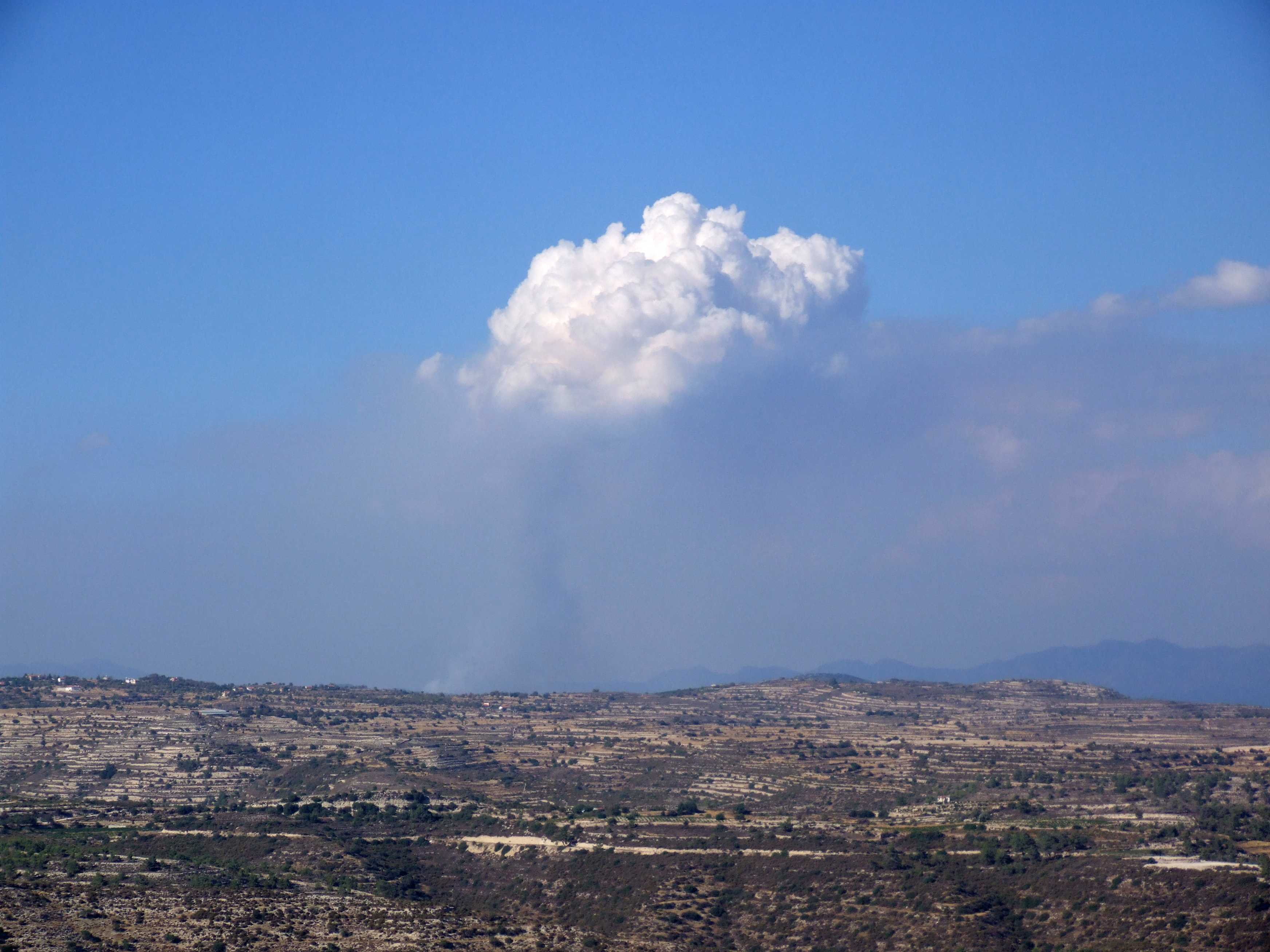
Cumulus congestus flammagenitus
A Cumulus congestus flammagenitus cloud is seen in this picture above a low-level layer of smoke. The cloud formed as a direct result of the convection of air above a wildfire.
The wildfire, located near Potamissa in the Limassol District of Cyprus, was approximately 20 km away from where the picture was taken near the village of Kivides. The base of the cloud is partially obscured by smoke rising directly from the fire and by a layer of smoke spreading in the lower atmosphere. Other Cumulus clouds of natural origin, on the right of the picture, are partially hidden by smoke.
The Cumulus flammagenitus cloud is identified as the species congestus by its relatively large extent, the resemblance of its bulging upper part to a cauliflower and the towers sprouting from the cloud top. Observation over time showed that these towers rose from the main body of the cloud only to dissipate in the dry atmosphere above.
Links in the image description will highlight features on the image. Mouse over the features for more detail.
© George AndersonKivides, CyprusLatitude: 34° 45' 41'' NLongitude: 32° 50' 41'' E06 August 2007 1708 (Local Time)Camera direction: towards NNECL = 2, CM = 0, CH = 0Image P/S code: S.9.16Image I.D.: 4834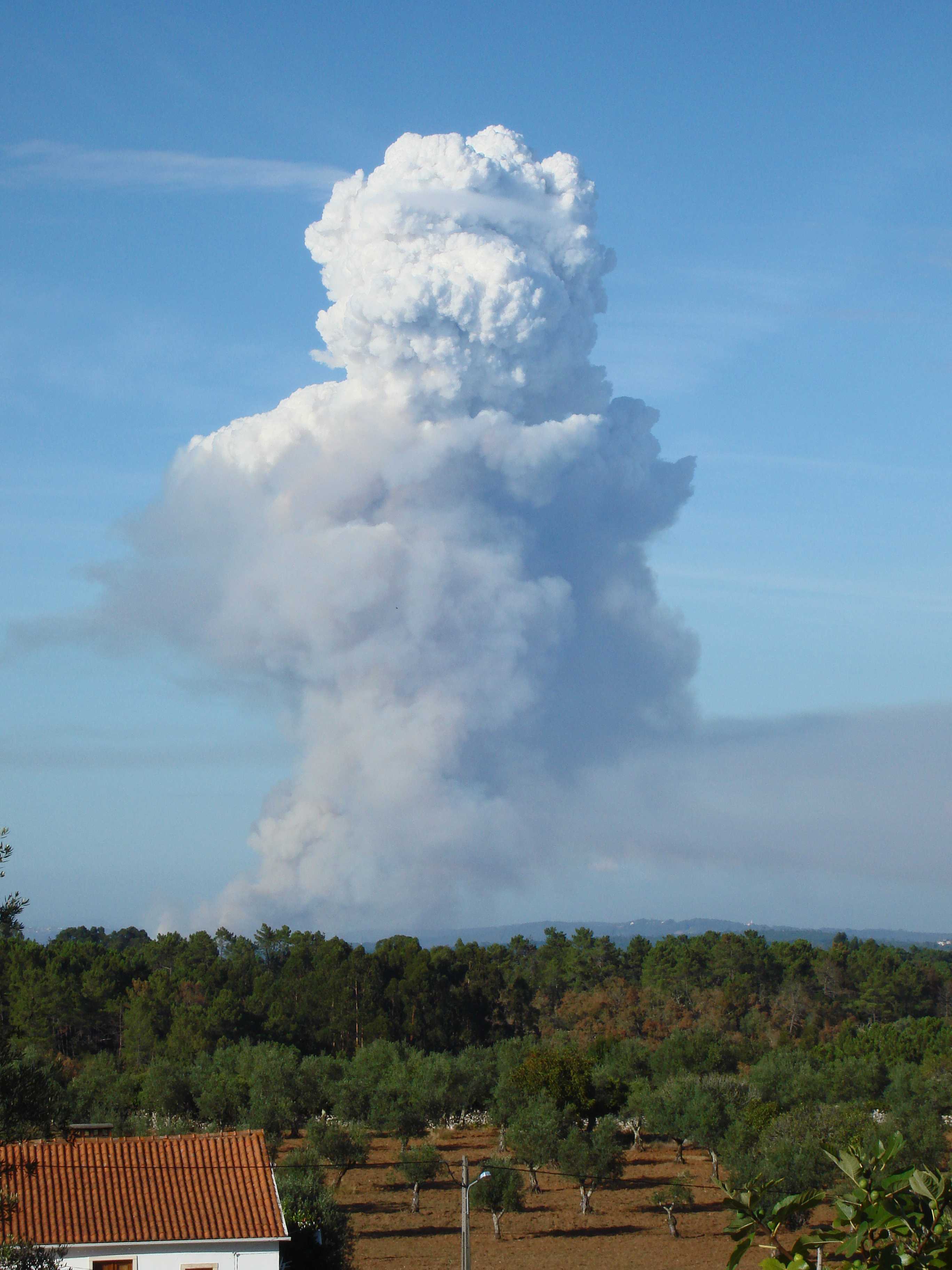
Cumulus congestus flammagenitus
This picture, taken from Serra de Alvorge in Portugal, shows a Cumulus congestus generated as a result of rising thermals from a wildfire. It is therefore classified as Cumulus congestus flammagenitus.
Light, north-westerly, low-level winds caused smoke from the wildfire to drift slowly to the south-east and some smoke also rose vertically into the lower atmosphere. However, the atmosphere was deeply unstable above about 2 300 m and the convective plume rose quickly to considerable height, resulting in the formation of a tower of Cumulus congestus flammagenitus.
Links in the image description will highlight features on the image. Mouse over the features for more detail.
© Jan KnightSerra de Alvorge, PortugalLatitude: 39° 59' 5'' NLongitude: 8° 27' 58'' W18 September 2012 1635 (Local Time)CL = 2, CM = 0, CH = 0Image P/S code: P.9.16Image I.D.: 4654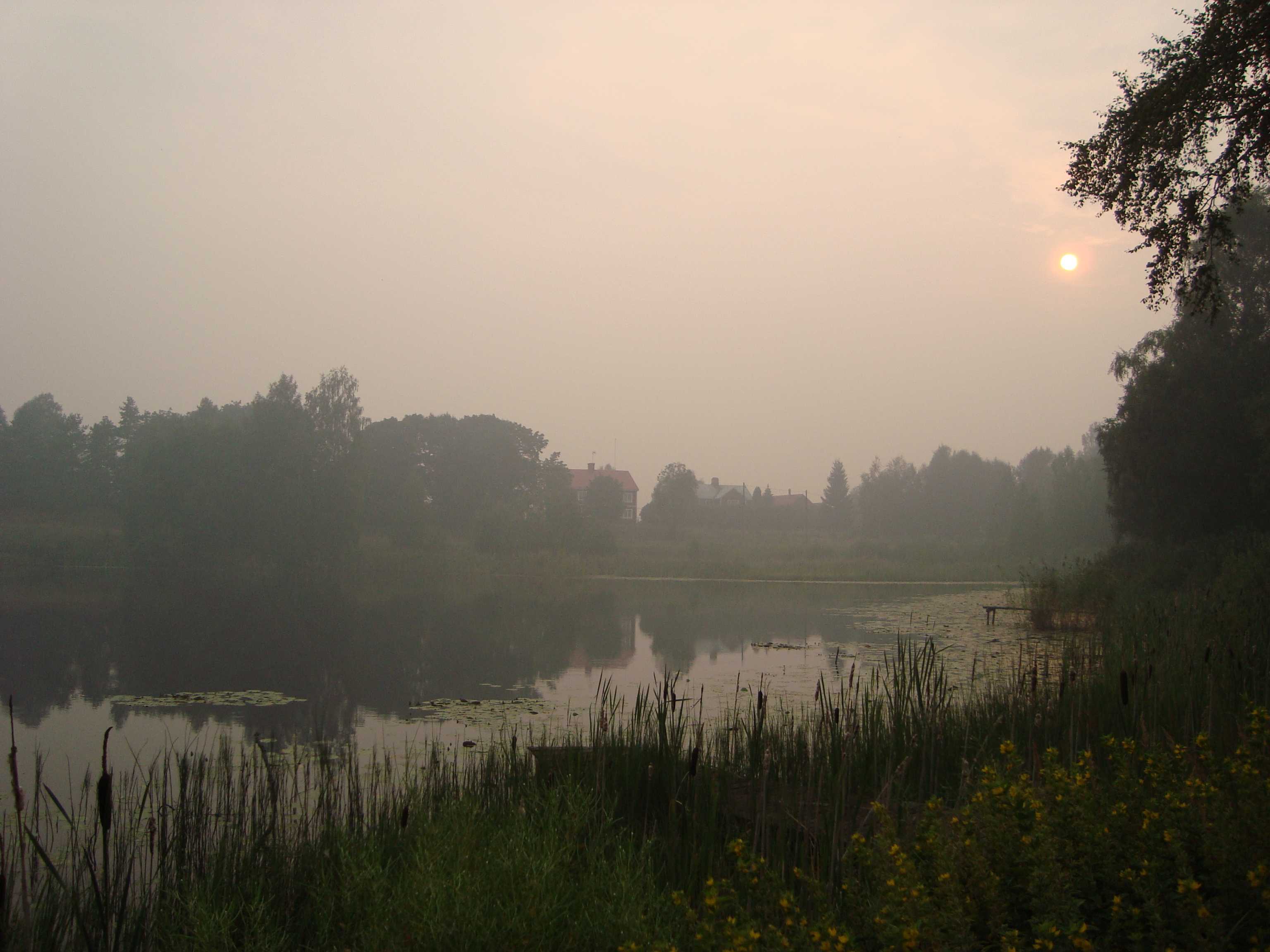
Smoke from a forest fire
The reduced visibility in this picture (to about 2 km) was due to smoke in the atmosphere from one of the largest forest fires to ever have occurred in Sweden. Smoke is a suspension in the air of small particles produced by combustion.
Links in the image description will highlight features on the image. Mouse over the features for more detail.
© Hans ÖstlundAvesta SV, SwedenLatitude: 60° 5' 54'' NLongitude: 16° 18' 13'' E05 August 2014 1913 (Local Time)Camera direction: towards WCL = 2, CM = 0, CH = 0Image P/S code: S.12.1.3Image I.D.: 4699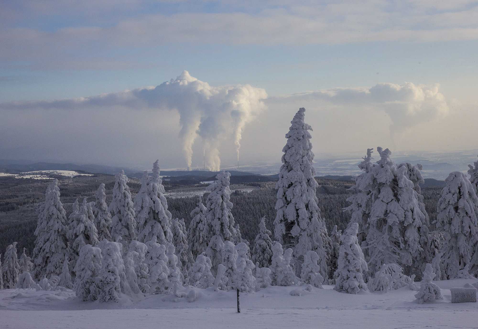
Stratocumulus cumulogenitus homogenitus
This photograph shows how rising thermals from the power plants Prunéřov, Tušimice and Počerady in the Czech Republic have generated Cumulus congestus homogenitus clouds at 1, 2 and 3. These clouds have spread out to form Stratocumulus under an inversion, at a height of about 2 500 m. As the Stratocumulus has formed by the spreading of Cumulus, the mother-cloud term cumulogenitus applies. Furthermore, as the clouds formed as a consequence of human activity, the name homogenitus also applies. This cloud is therefore Stratocumulus cumulogenitus homogenitus. There is a slight reduction of visibility on the horizon due to haze and, downwind from the chimneys, smoke resulting from additional particulate matter from the chimneys.
Links in the image description will highlight features on the image. Mouse over the features for more detail.
© Karlona PlskovaJáchymov, Czech RepublicLatitude: 50° 23' 45'' NLongitude: 12° 58' 5'' E18 January 2016 1118 (Local Time)Camera direction: towards SECL = 4, CM = 3, CH = 0Image P/S code: S.7.23Image I.D.: 4892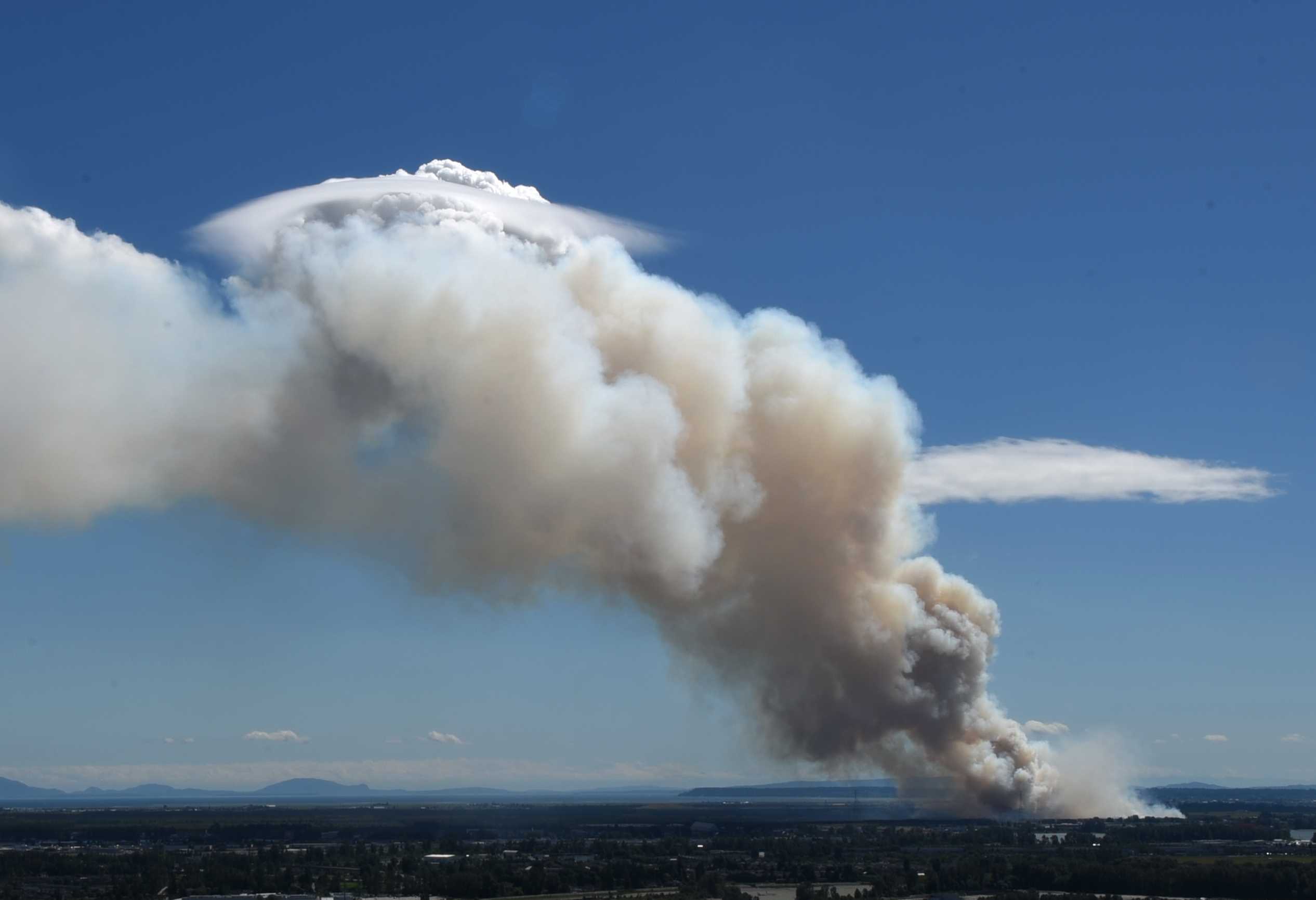
Cumulus congestus pileus flammagenitus
This picture, taken towards the south from Vancouver, British Columbia, Canada, shows Cumulus flammagenitus, generated as a result of rising thermals from a wildfire. The top of the cloud displays strong sproutings with sharp outlines and indicates the species congestus. Furthermore, the rising thermals have penetrated an elevated moist layer of air, generating a pileus accessory cloud. South-westerly low-level winds have caused a plume of smoke from the wildfire to drift to the north-east, obscuring the base of the Cumulus from the observer. The sky is otherwise largely clear with only a few Cumulus humilis clouds.
The accompanying time-lapse video shows the development of the various features seen in this photograph.
Links in the image description will highlight features on the image. Mouse over the features for more detail.
© Irene HoVancouver, CanadaLatitude: 49° 16' 58'' NLongitude: 123° 7' 15'' W03 July 2016 1508 (Local Time)Camera direction: towards SCL = 2, CM = 0, CH = 0Image P/S code: S.9.16 3Image I.D.: 5033
Cumulus flammagenitus
Smoke originating from a gorse fire to the north (right side of the image) can be seen blowing towards the left. The heat produced by the fire was sufficient to induce the development of a Cumulus, which can be seen above the smoke layer. The Cumulus is transitioning from humilis into mediocris at 3 and 4, as indicated by the sproutings.
Links in the image description will highlight features on the image. Mouse over the features for more detail.
© Frank Le BlancqJersey Airport, St Peter, JerseyLatitude: 49° 12' 24'' NLongitude: 2° 11' 52'' W10 September 2009 1557 (Local Time)Camera direction: towards WNWCL = 2, CM = 0, CH = 0Image P/S code: S.9.16 2Image I.D.: 5082