© Stephen Burt
Stratfield Mortimer, near Reading, Berkshire, United Kingdom of Great Britain and Northern Ireland
Latitude: 51° 22' 12'' N
Longitude: 1° 2' 24'' W
24 July 2013 1755 (Local Time)
Camera direction: towards NE
Image P/S code: P.1.0
Image I.D.: 4843
CL = 0, CM = 0, CH = 4
-

Cirrus fibratus, increasing
Following a sunny and warm afternoon, Cirrus fibratus at 1 and 2 spread rapidly across the sky from the west in advance of an occluded front. Some dense entangled filaments of the variety intortus are seen in the centre and an aircraft condensation trail is visible to the lower left of the image.
Links in the image description will highlight features on the image. Mouse over the features for more detail.
© Stephen BurtStratfield Mortimer, near Reading, Berkshire, United Kingdom of Great Britain and Northern IrelandLatitude: 51° 22' 12'' NLongitude: 1° 2' 24'' W24 July 2013 1755 (Local Time)Camera direction: towards NECL = 0, CM = 0, CH = 4Image P/S code: P.1.0Image I.D.: 4843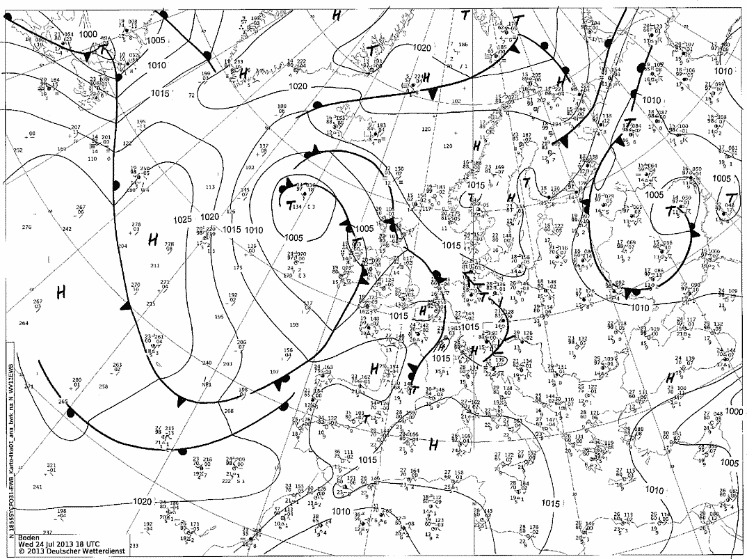
An occluded front approaching from the west after a fine summer's day
© Deutscher Wetterdienst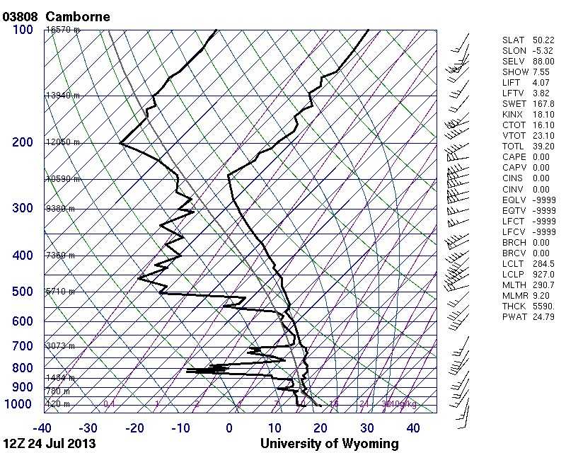
This is the 1200 UTC ascent from almost eight hours earlier at Camborne, England, UK (03808), which is 325 km south-west and nearer to the frontal zone.
© University of Wyoming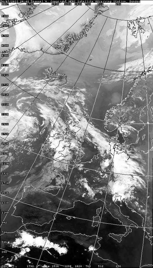
This infrared image from just over an hour later shows the extensive area of high cloud advancing ahead of the occluded front.
© NEODAAS/University of Dundee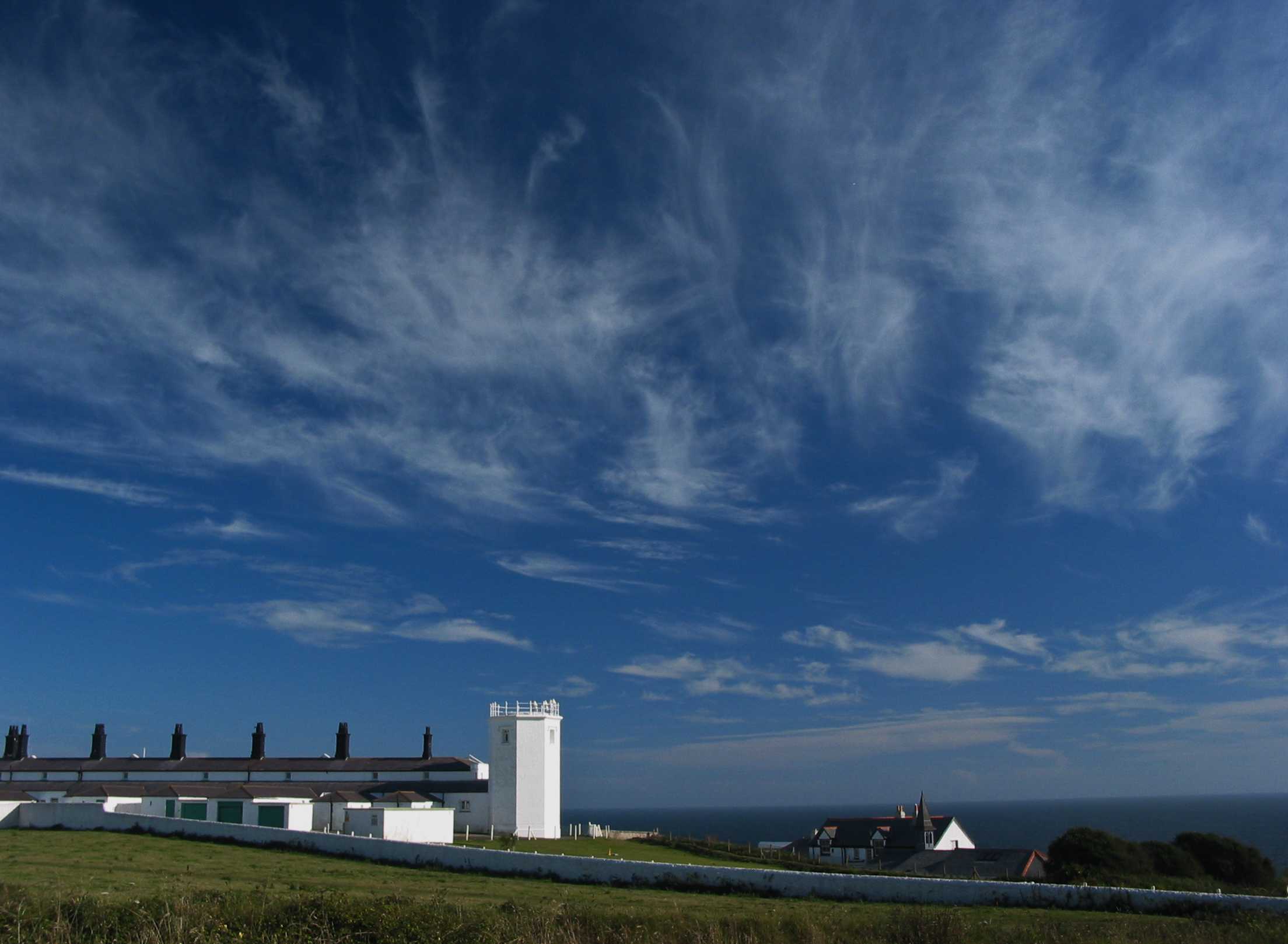
Cirrus fibratus intortus, Cirrus spissatus and Altocumulus
Very irregularly curved white filaments of Cirrus fibratus dominate this image. The filaments are sufficiently irregularly curved and entangled to suggest a mild form of the variety intortus. The Cirrus fibratus appears to have evolved from Cirrus floccus, a few elements of which are low on the horizon. There is also a small line of Cirrus castellanus, a thin sheet of Altocumulus and, right on the horizon, two contrails. With a depression lying to the south-west of the British Isles and a trough extending over England, UK, the day was showery over south-west England, with a morning thunderstorm and extensive convective cloud. The extreme coastal areas remained mostly sunny during the afternoon.
Links in the image description will highlight features on the image. Mouse over the features for more detail.
© Stephen BurtLizard, Helston, United Kingdom of Great Britain and Northern IrelandLatitude: 49° 57' 39'' NLongitude: 5° 12' 14'' W10 August 2004 1640 (Local Time)Camera direction: towards SECL = 0, CM = 3, CH = 1Image P/S code: S.1.8Image I.D.: 5175