© Frank Le Blancq
Noirmont Common, Jersey
Latitude: 49° 10' 29'' N
Longitude: 2° 10' 7'' W
19 July 2011 0551 (Local Time)
Camera direction: towards ENE
Image P/S code: P.11.1.1.3.1
Image I.D.: 4867
-
Ground fog/shallow fog
Radiation fog is formed when the ground surface cools through radiation (usually at night), cooling the air just above the ground to its saturation temperature. When the fog occurs in a shallow enough layer that it does not restrict horizontal visibility when viewed from a height of about 2 m, it is known as ground fog or shallow fog.
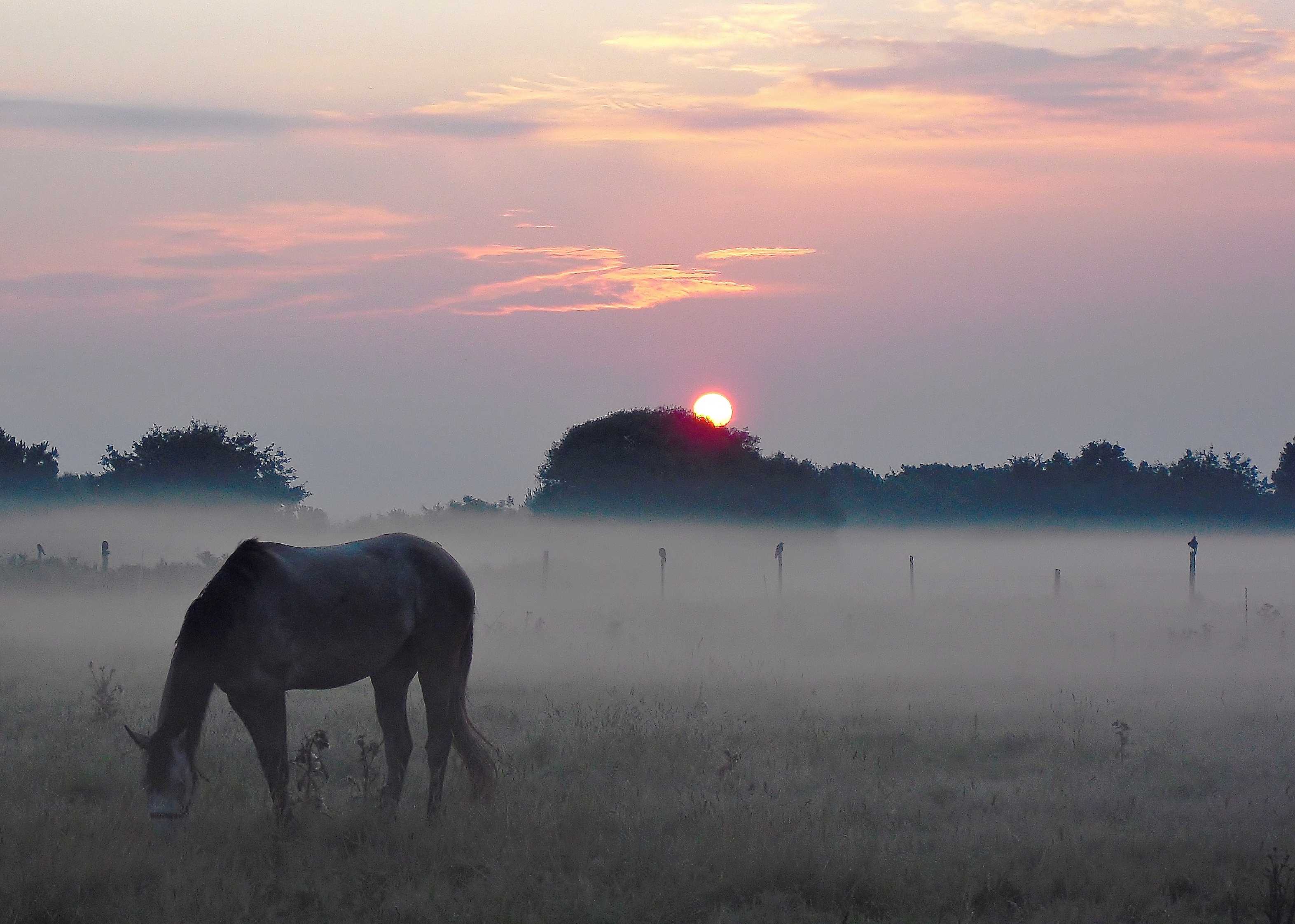
This image shows an extensive layer of shallow fog (less than 2 m in depth) that has formed over a field of grass. The crows in the background are perched on posts approximately 1 m in height. Small amounts of Altocumulus and Cirrus cloud are in the sky and the visibility over the top of the ground fog is fairly good.
Links in the image description will highlight features on the image. Mouse over the features for more detail.
© Frank Le BlancqNoirmont Common, JerseyLatitude: 49° 10' 29'' NLongitude: 2° 10' 7'' W19 July 2011 0551 (Local Time)Camera direction: towards ENEImage P/S code: P.11.1.1.3.1Image I.D.: 4867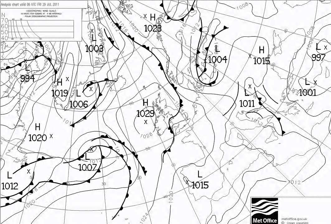
High pressure of 1 029 hPa was centred off north-west Ireland, with low pressure in the mid-Atlantic (1 007 hPa) and over the Baltic states (1 004 hPa). A very slack pressure gradient covered the western English Channel. At the time of the image, the wind at 10 m was 10° at 3 kt. Light winds and relatively clear skies overnight allowed the temperature to fall to a minimum of 13.2 °C, but the grass minimum was a much cooler 6.6 °C.
© Crown Copyright
The Herstmonceux, England, UK (WMO 03882) sounding in the same airstream at 0001 UTC shows an inversion of 2 °C in the lowest 4 hPa (34 m). The synoptic station at nearby Jersey Airport, Jersey reported a grass minimum of 6.6 °C, which was nearly 7 °C less than the minimum temperature at screen height, allowing saturation to occur at ground level.
© University of Wyoming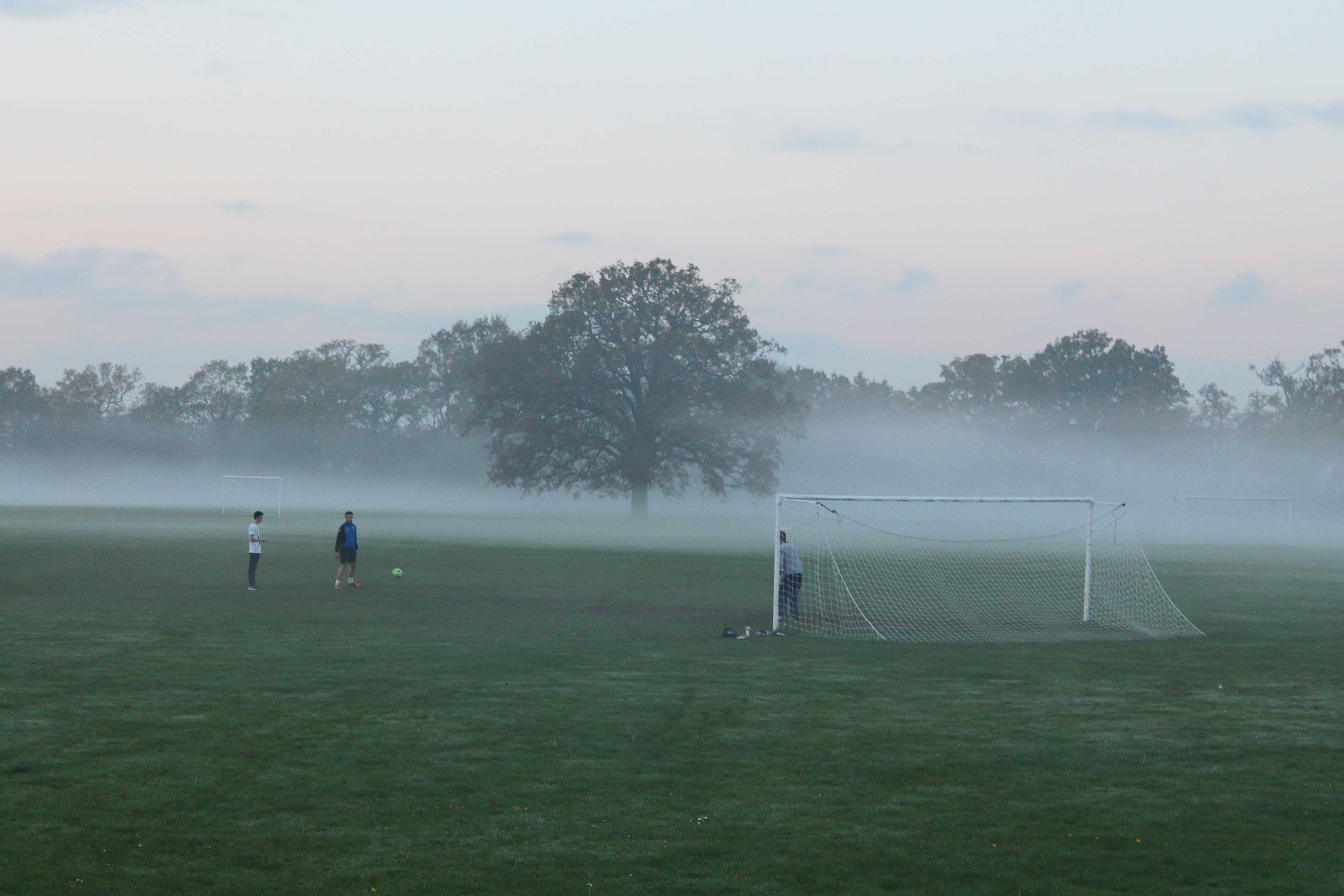
Ground fog thickening into fog
Radiation fog is formed when the ground surface cools through radiation, usually at night, cooling the air just above the ground to its saturation temperature. When the fog occurs in a shallow enough layer that it does not restrict horizontal visibility when viewed from a height of about 2 m, it is known as ground fog, or shallow fog.
This picture, taken a few minutes before sunset over playing fields at Wokingham in southern England, UK on a day in late autumn, shows ground fog thickening into fog.
A complex area of low pressure was situated to the west of UK with a slack surface airflow over southern England. The air temperature (at a height of 1.25 m above the ground) reached a maximum of 12 °C early in the afternoon and then fell quickly towards sunset under clearing skies. By the time of this photograph at 1610 hours, it had fallen to 9 °C, while the temperature at the grass surface had fallen from 15 °C in the early afternoon to 3 °C. The low-level air near the grass surface became saturated and patches of ground fog formed. Some parts of the ground fog then subsequently began to deepen to a height greater than 2 m to become proper fog, as seen here. For reference, the goal posts are 2.44 m high.
Links in the image description will highlight features on the image. Mouse over the features for more detail.
© George AndersonWokingham, United Kingdom of Great Britain and Northern IrelandLatitude: 51° 25' 18'' NLongitude: 0° 50' 15'' W15 November 2014 1610 (Local Time)Camera direction: towards NWImage P/S code: S.11.1.1.3 1Image I.D.: 4696Sun pillar
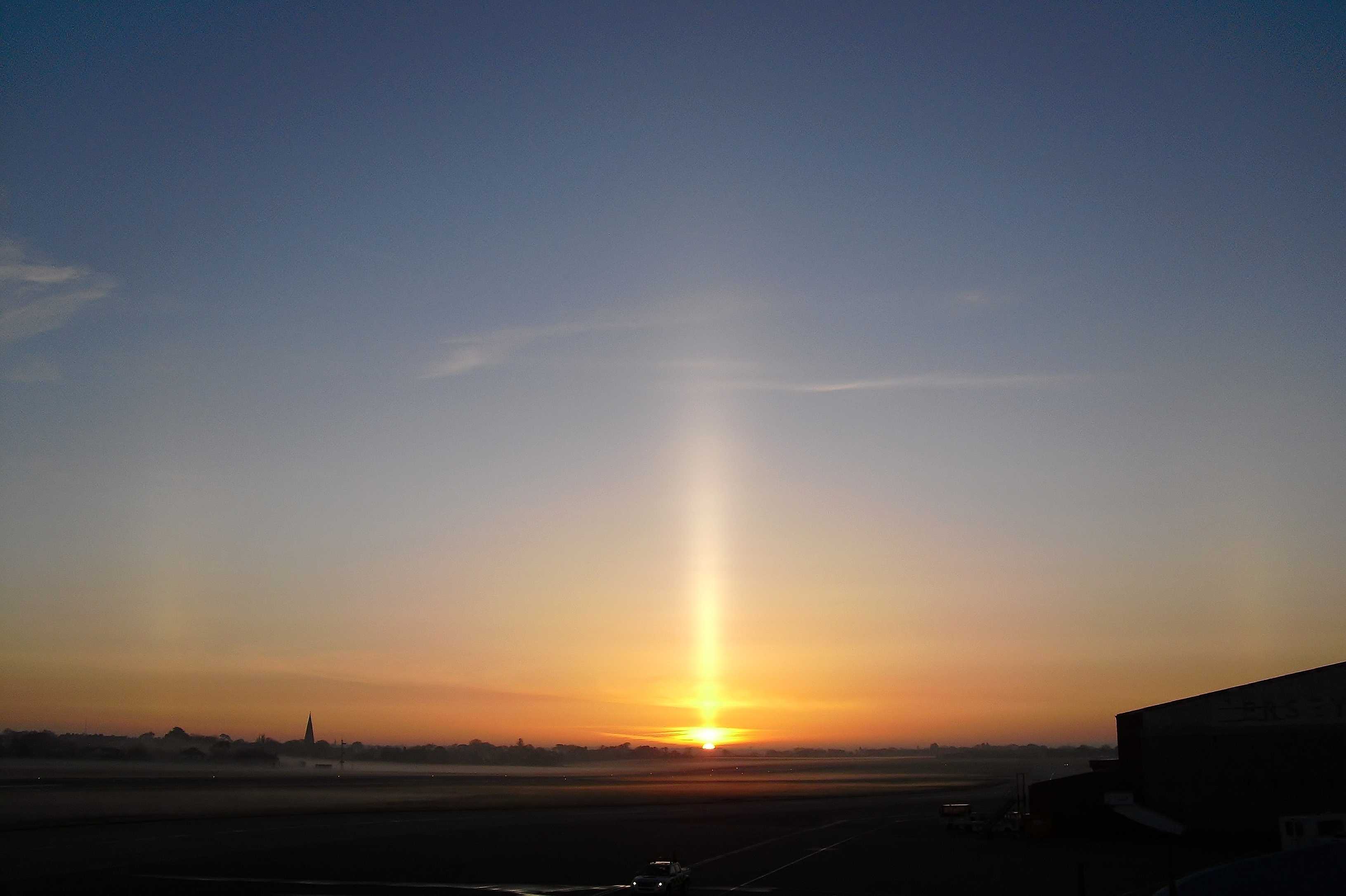
This photograph, taken at Jersey Airport, Jersey, shows a sun pillar on the point of sunrise. The sun pillar indicates the presence of Cirrostratus and is formed by the reflection of sunlight from plate-like ice crystals. The Cirrostratus is very thin and featureless with no distinct detail, and thus is the species nebulosus. A few small patches of Cirrus are also in the sky. Reports indicate that sun pillars were visible over southern England, UK and northern France. A small patch of shallow fog is visible on the runway.
Links in the image description will highlight features on the image. Mouse over the features for more detail.
© Frank Le BlancqJersey Airport, JerseyLatitude: 49° 12' 23'' NLongitude: 2° 11' 44'' W27 April 2010 0558 (Local Time)Camera direction: towards NEImage P/S code: P.13.1.3.1Image I.D.: 4701Ground fog/shallow fog and mist
Ground fog, also known as shallow fog, is a radiation fog that is shallow in depth. Over land, the depth is defined as 2 m or less; above this height, the horizontal visibility is not restricted by the fog.
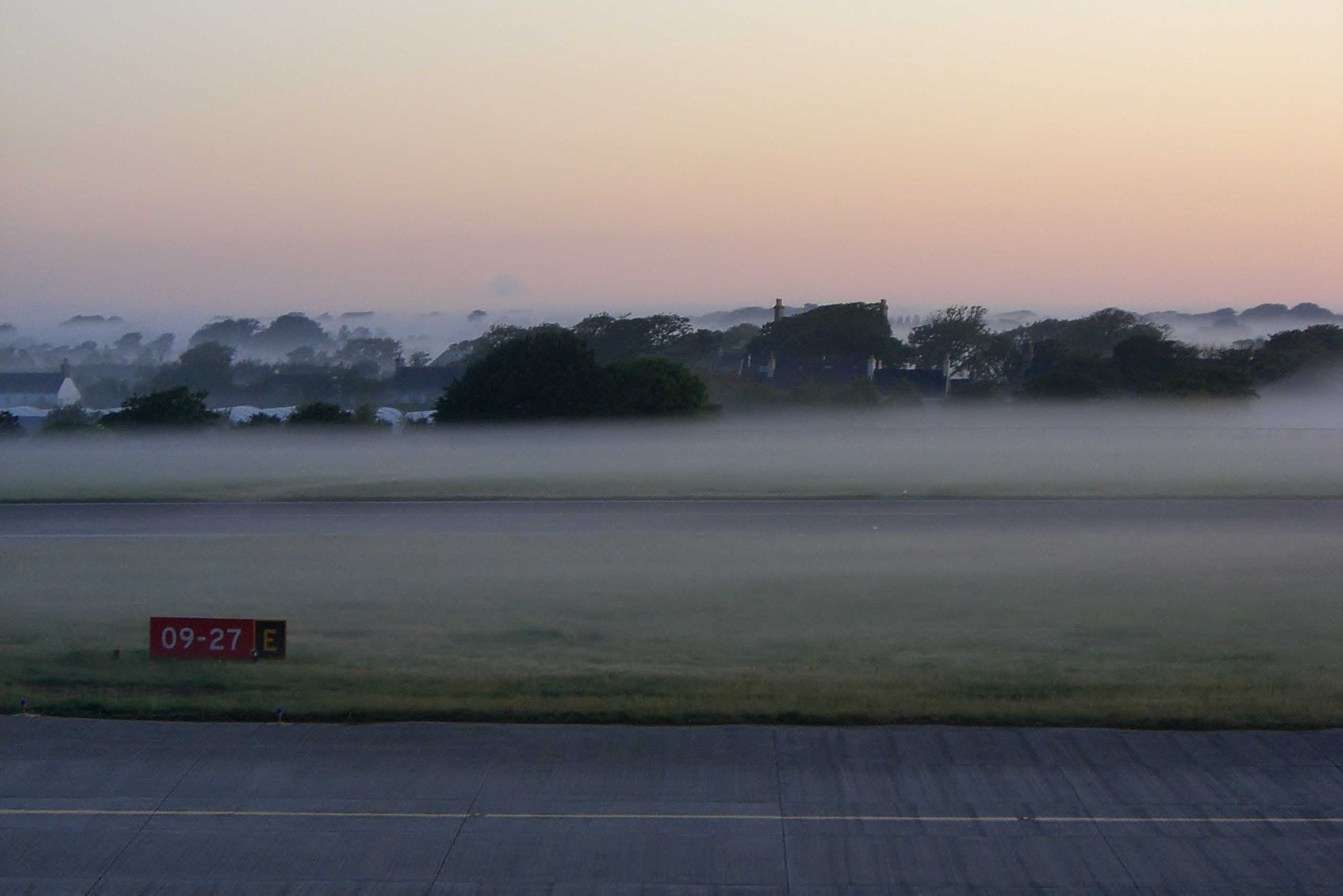
This picture was taken at Jersey Airport, Jersey (WMO 03895), about 15 minutes before sunrise. In the background, the fog at 2 and 3 has thickened to a depth greater than 2 m. The complex microphysics of fog formation is shown here, as shallow fog has formed over grass (grass minimum: 2.0 °C), but has not formed over the taxiway or runway (concrete minimum: 4.9 °C). The air minimum was 8.4 °C.
With the general relative humidity of the air measured as 97%, the reduction in horizontal visibility above the ground fog to 7 km is due to mist.
Links in the image description will highlight features on the image. Mouse over the features for more detail.
© Frank Le BlancqJersey Airport, St Peter, JerseyLatitude: 49° 12' 25'' NLongitude: 2° 11' 51'' W02 June 2007 0453 (Local Time)Camera direction: towards NImage P/S code: S.11.1.1.3.1 2Image I.D.: 4872Shallow fog with glory
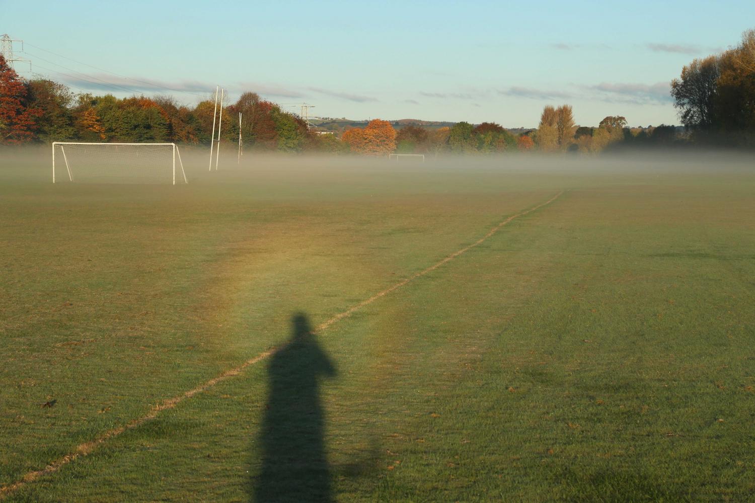
Shallow fog and a glory are seen in this photograph taken at Exeter University Playing Fields, Exeter, England, UK, early on an autumn morning. The glory is formed by the interaction of sunlight with numerous very small water droplets – in this case, either dew or saturated air at the ground.
Radiation fog is formed when the ground surface cools through radiation, usually at night, cooling the air just above the ground to its saturation temperature. When the fog occurs in a shallow enough layer that it does not restrict horizontal visibility when viewed from a height of about 2 m, it is known as ground fog or shallow fog. For reference, the goal post is 2.44 m high.
Links in the image description will highlight features on the image. Mouse over the features for more detail.
© Matthew ClarkExeter, United Kingdom of Great Britain and Northern IrelandLatitude: 50° 42' 15'' NLongitude: 3° 30' 37'' W05 November 2016 0815 (Local Time)Camera direction: towards WNWImage P/S code: S.11.1.1.3.1 3Image I.D.: 5022
