© Frank Le Blancq
St Brelade, Jersey
Latitude: 49° 11' 13'' N
Longitude: 2° 11' 12'' W
13 March 2007 0857 (Local Time)
Camera direction: towards W
Image P/S code: P.4.17
Image I.D.: 5137
CL = 0, CM = 7, CH = /
-
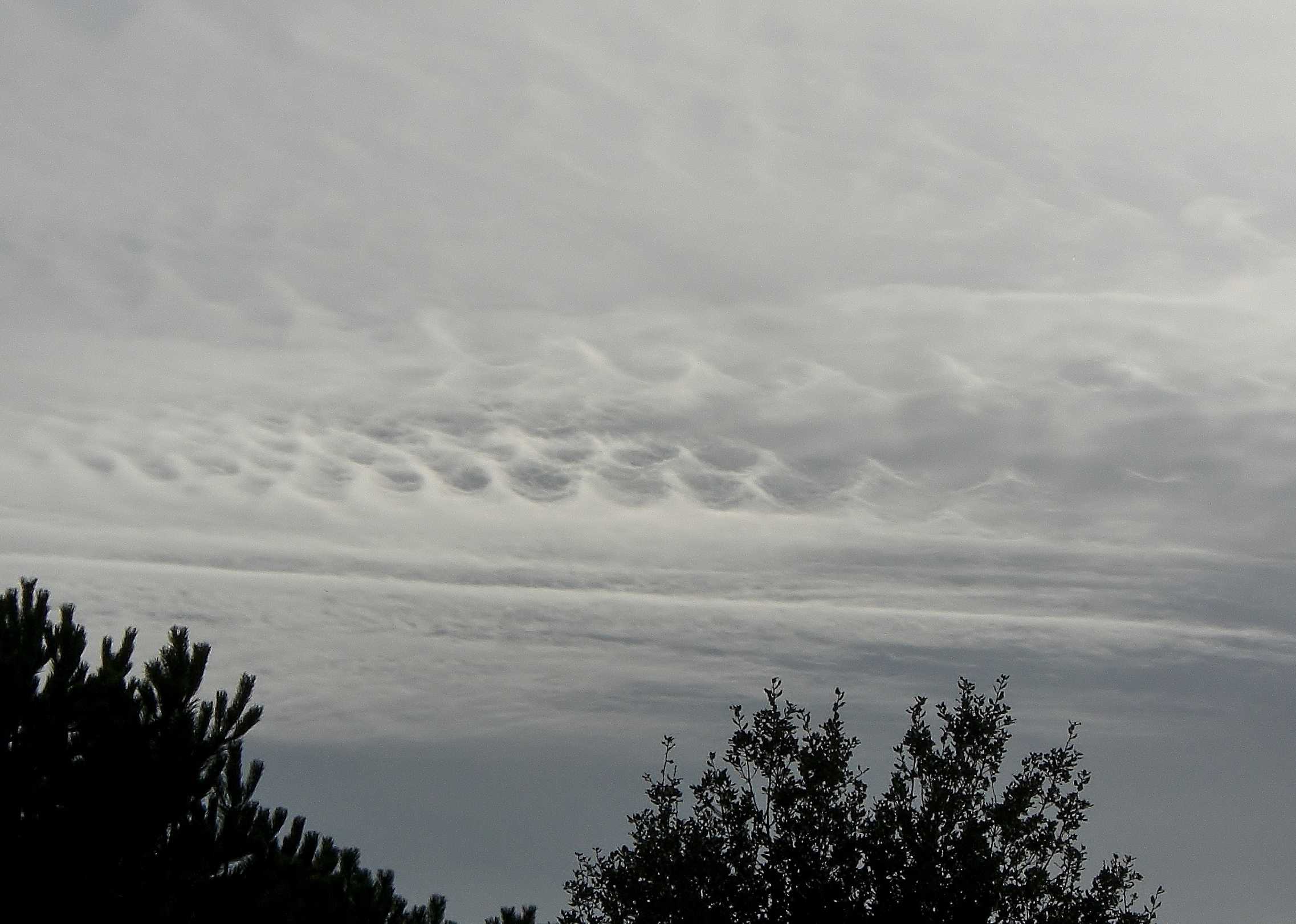
Altocumulus stratiformis opacus duplicatus fluctus
A very unusual feature of this sky is the presence of four or five trains of Kelvin-Helmholtz waves (the supplementary cloud feature fluctus). The train of waves at the upper right is dissipating; three trains of waves (seen at 2, 3 and 4) are clearly visible in the centre; and there is probably another train on the left, slightly above centre. Fluctus is a relatively short-lived wave formation on the top surface of a cloud and is formed as a result of wind shear across the cloud top.
The extensive sheet of opaque cloud in the picture shows some form to the cloud elements and is Altocumulus stratiformis opacus. There are two layers, so the variety duplicatus also applies. The layer beneath appears lighter and thinner where the waves have formed. Near the bottom of the photograph, the featureless, darker grey cloud is typical of Altostratus opacus.
Links in the image description will highlight features on the image. Mouse over the features for more detail.
© Frank Le BlancqSt Brelade, JerseyLatitude: 49° 11' 13'' NLongitude: 2° 11' 12'' W13 March 2007 0857 (Local Time)Camera direction: towards WCL = 0, CM = 7, CH = /Image P/S code: P.4.17Image I.D.: 5137
A weak cold front was moving south-east over north-west France. It was estimated to be about 120 km beyond the location of the photograph, with a ridge of high pressure extending north-east along the English Channel.
© Deutscher Wetterdienst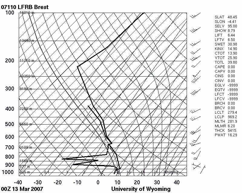
The Brest, France (WMO 07110) sounding at 0000 UTC was about 160 km behind the cold front and considered a reasonable representation of conditions over the photograph location. A very dry zone is present below 700 hPa, which is typical of a post-cold front air mass. Saturated or near-saturated air is present above 660 hPa (around 3 600 m). Wind at cloud level was estimated to be blowing from 210° at 20 kt (10 m/s).
© University of Wyoming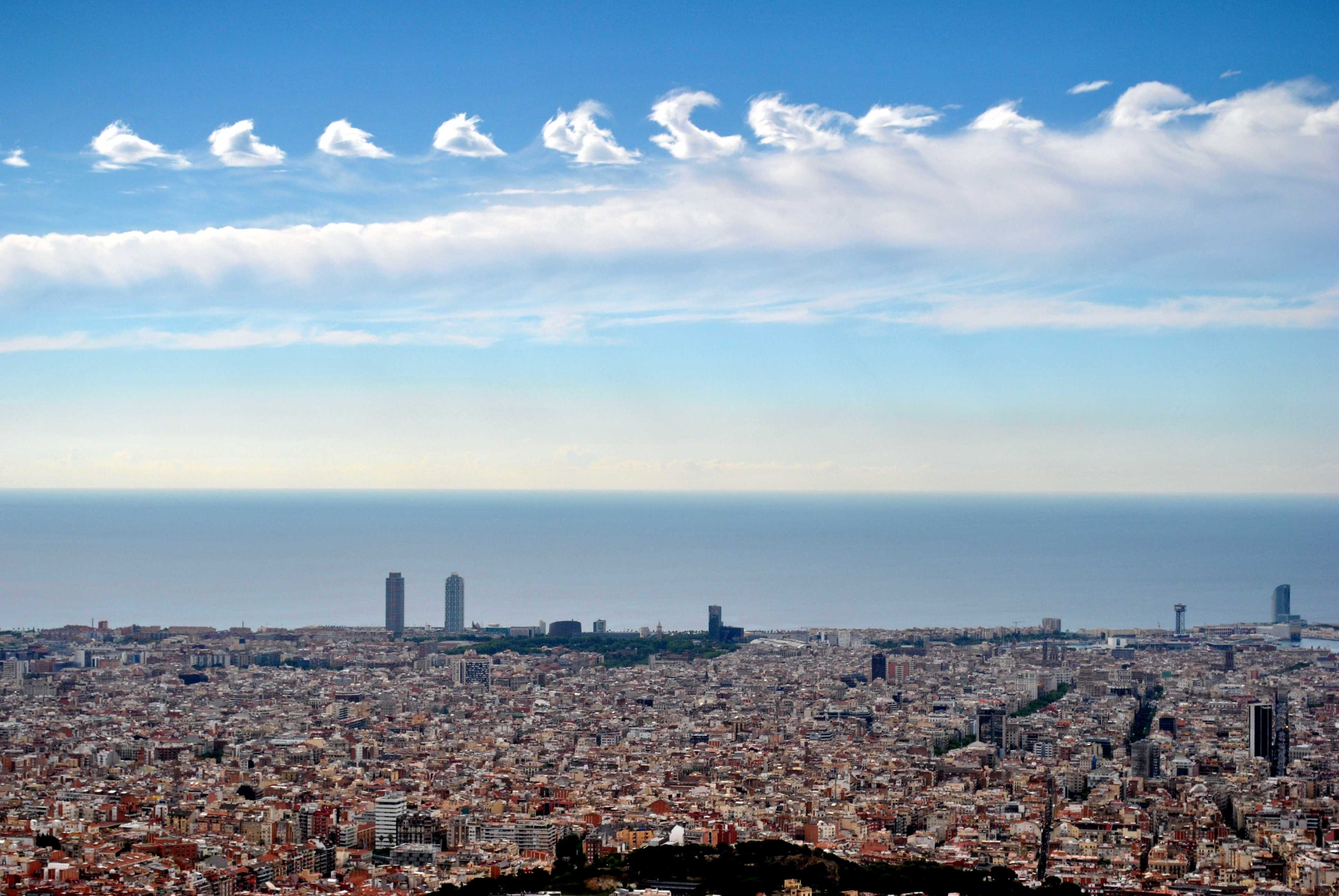
Altocumulus fluctus and Altocumulus floccus with virga
The outstanding feature of this image is the fluctus. Commonly known as Kelvin-Helmholtz waves or billows, this is a new supplementary feature in the International Cloud Atlas, Revised Edition 2017. The fluctus elements are casting shadows that appear to be converging toward the horizon – these are crepuscular rays.
Behind the fluctus and at about the same base is a line of merged floccus tufts, from which ice crystal virga is falling. Both the fluctus and floccus are of the genus Altocumulus.
The remains of two lines of floccus are further away at 1 and 2; the cloud in both these lines has transitioned from water droplets to ice and is classified as Cirrus spissatus altocumulogenitus.
A layer of haze is lying offshore. In front of this haze is a distant line of Cumulus congestus.
Links in the image description will highlight features on the image. Mouse over the features for more detail.
© Alfons PuertasVallvidrera - el Tibidabo i les Planes, Barcelona, Barcelona, SpainLatitude: 41° 25' 6'' NLongitude: 2° 7' 27'' E25 June 2014 1000 (Local Time)Camera direction: towards SECL = 2, CM = 8, CH = 0Image P/S code: S.4.17Image I.D.: 4762