© Michael Bruhn
Aspendale Gardens VIC 3195, Australia
Latitude: 37° 48' 37'' S
Longitude: 144° 57' 16'' E
13 January 2007 0827 (Local Time)
Camera direction: towards ENE
Image P/S code: P.1.11
Image I.D.: 5628
CL = 1, CM = 0, CH = 1
-
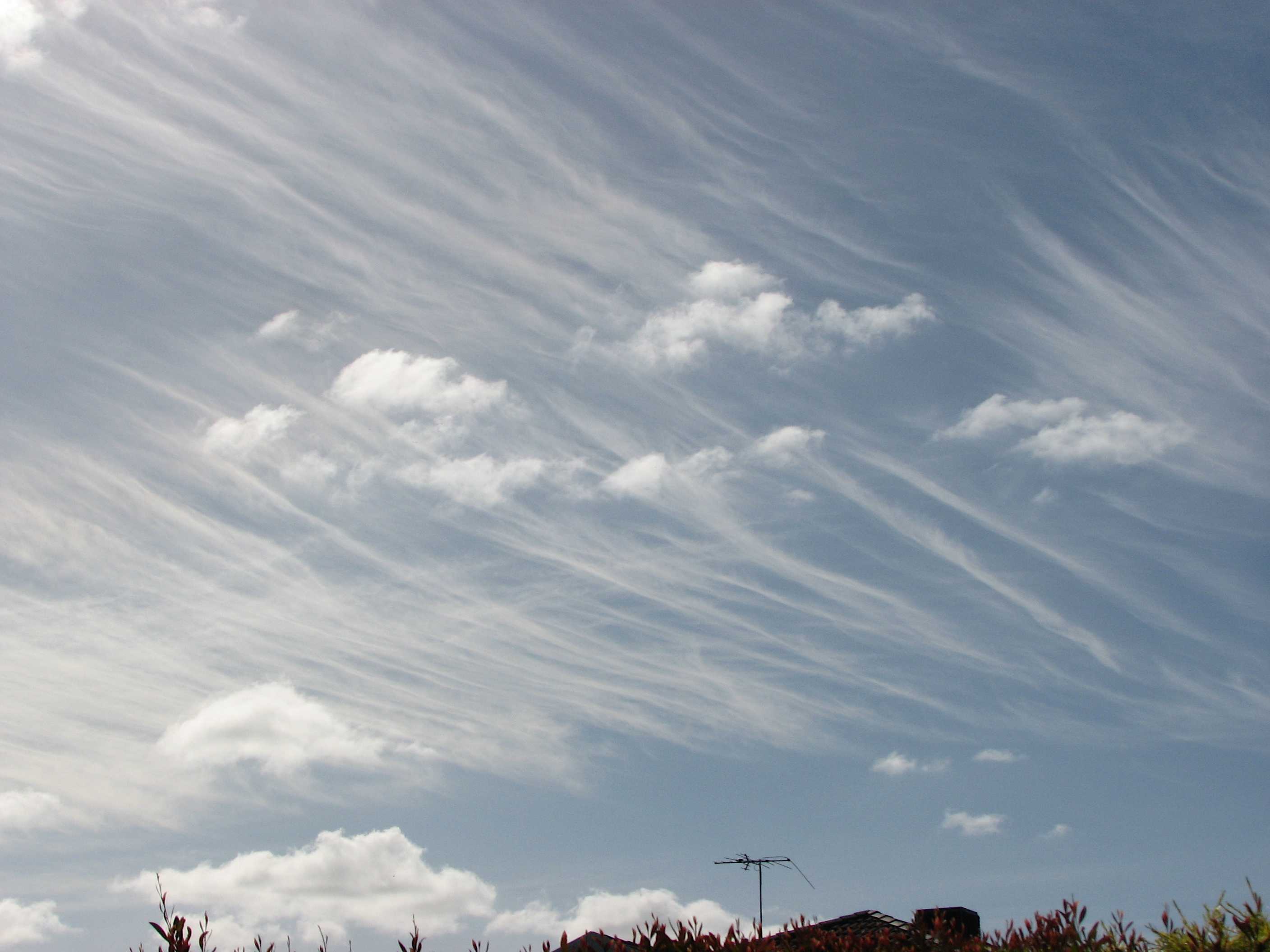
Cirrus fibratus duplicatus and Cumulus humilis and fractus
This is Cirrus of the species fibratus (indicated by nearly straight or more or less irregularly curved filaments) in two layers. The lower, predominant layer is aligned east-west, while the higher layer is aligned north-south. Cumulus fractus of good weather and Cumulus humilis are also present.
Links in the image description will highlight features on the image. Mouse over the features for more detail.
© Michael BruhnAspendale Gardens VIC 3195, AustraliaLatitude: 37° 48' 37'' SLongitude: 144° 57' 16'' E13 January 2007 0827 (Local Time)Camera direction: towards ENECL = 1, CM = 0, CH = 1Image P/S code: P.1.11Image I.D.: 5628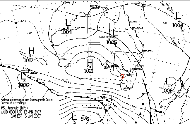
Weak ridge extending from the west with an inland trough developing to the north-west
© Commonwealth of Australia 2007, Bureau of Meteorology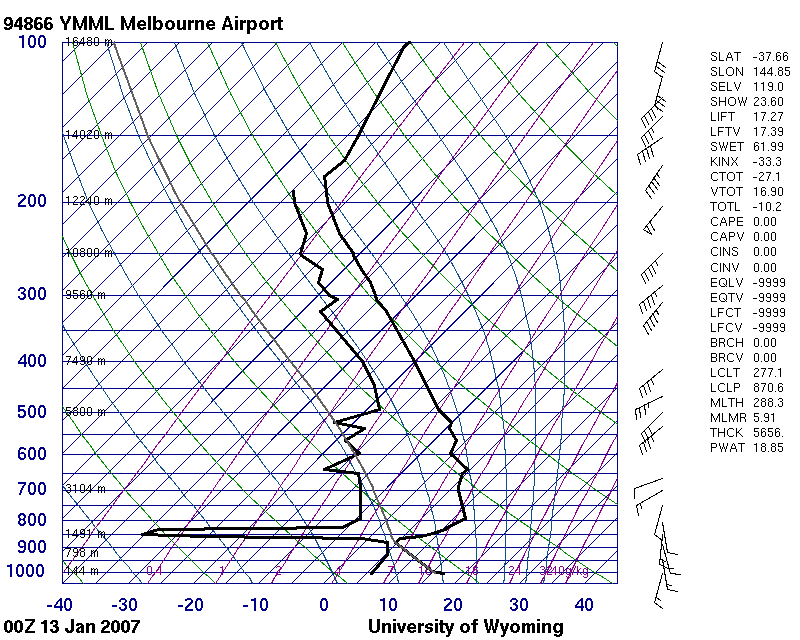
Unstable layer from surface to subsidence inversion at 1 200 m (879 hPa), significant moisture from 500 hPa to tropopause
© University of Wyoming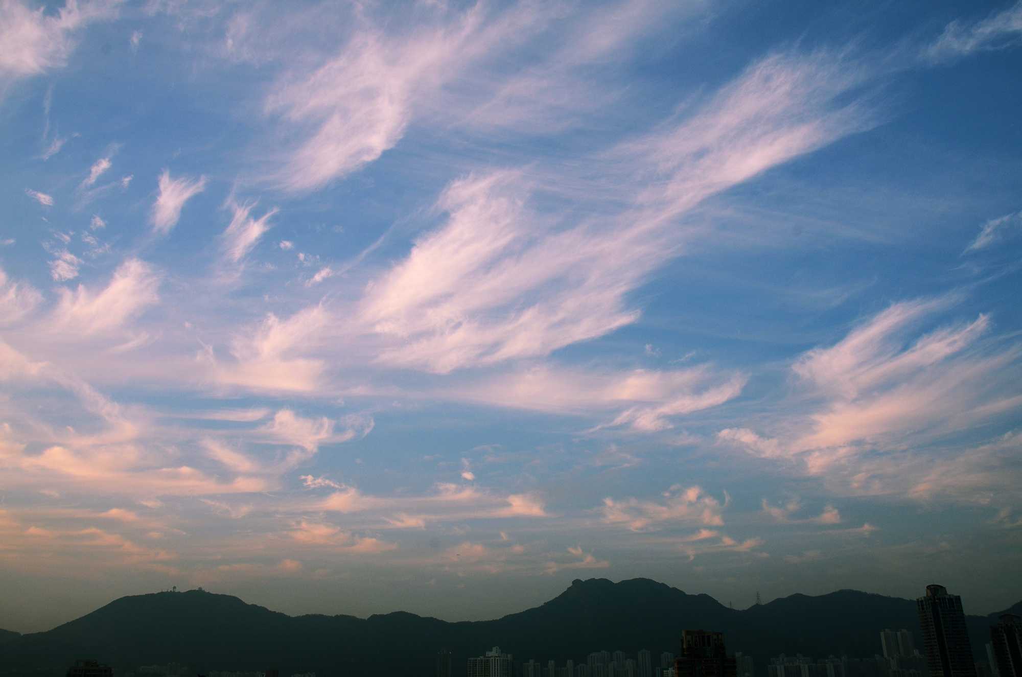
Cirrus fibratus duplicatus, uncinus, spissatus and floccus
Four species and one variety of Cirrus are on display in this image. The species, in order of development on the day, are: floccus, uncinus, fibratus and spissatus. The variety is duplicatus.
The rounded protuberances (cumuliform tops) identify the species floccus at 1 and 2. In the next stage of development, the rounded protuberances start dissipating and transition into tufts; this is characteristic of the beginning of the species uncinus, seen here. After this stage, the uncinus tufts dissipate, leaving a comma terminated at the top by a hook – unusually, there are no clear examples of this stage of uncinus in this image. Next, the wind distorts the hooks into irregularly curved or nearly straight filaments (species fibratus). With time, the fibratus merges into dense patches (species spissatus).
The variety duplicatus is used to denote that there are Cirrus clouds arranged at two different levels. The higher level is comprised of fine, nearly straight or slightly curved filaments (Cirrus fibratus).
Cirrus of the species uncinus and fibratus dominate, hence the coding of CH = 1.
Links in the image description will highlight features on the image. Mouse over the features for more detail.
© Tze Ching HoKowloon City, Hong Kong, ChinaLatitude: 22° 19' 51'' NLongitude: 114° 11' 31'' E04 March 2016 1815 (Local Time)Camera direction: towards NCL = 0, CM = 0, CH = 1Image P/S code: S.1.11Image I.D.: 5525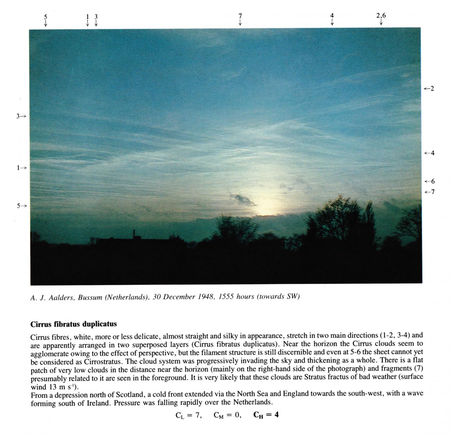
Cirrus fibratus duplicatus
Cirrus fibres, white, more or less delicate, almost straight and silky in appearance, stretch in two main directions(1 - 2, 3 - 4) and are apparently arranged in two superposed layers (Cirrus fibratus duplicatus). Near the horizon the Cirrus clouds seem to agglomerate owing to the effect of perspective, but the filament structure is still discernible and even at 5 - 6 the sheet cannot yet be considered as Cirrostratus. The cloud system was progressively invading the sky and thickening as a whole. There is a flat patch of very low clouds in the distance near the horizon (mainly on the right-hand side of the photograph) and fragments presumably related to it are seen in the foreground. It is very likely that these clouds are Stratus fractus of bad weather (surface wind 13 m s-1).
From a depression north of Scotland, a cold front extended via the North Sea and England towards the south-west, with a wave forming south of Ireland. Pressure was falling rapidly over the Netherlands.
Links in the image description will highlight features on the image. Mouse over the features for more detail.
© A.J. AaldersBussum, NetherlandsLatitude: 52° 16' 26'' NLongitude: 5° 9' 59'' E30 December 1948 1555 (Local Time)Camera direction: towards SWCL = 7, CM = 0, CH = 4