© Ben Clark
Lakelands, Western Australia, Australia
Latitude: 32° 28' 26'' S
Longitude: 115° 47' 3'' E
06 January 2016 1916 (Local Time)
Camera direction: towards SSE
Image P/S code: P.10.20
Image I.D.: 5742
CL = 9, CM = 6, CH = 3
-
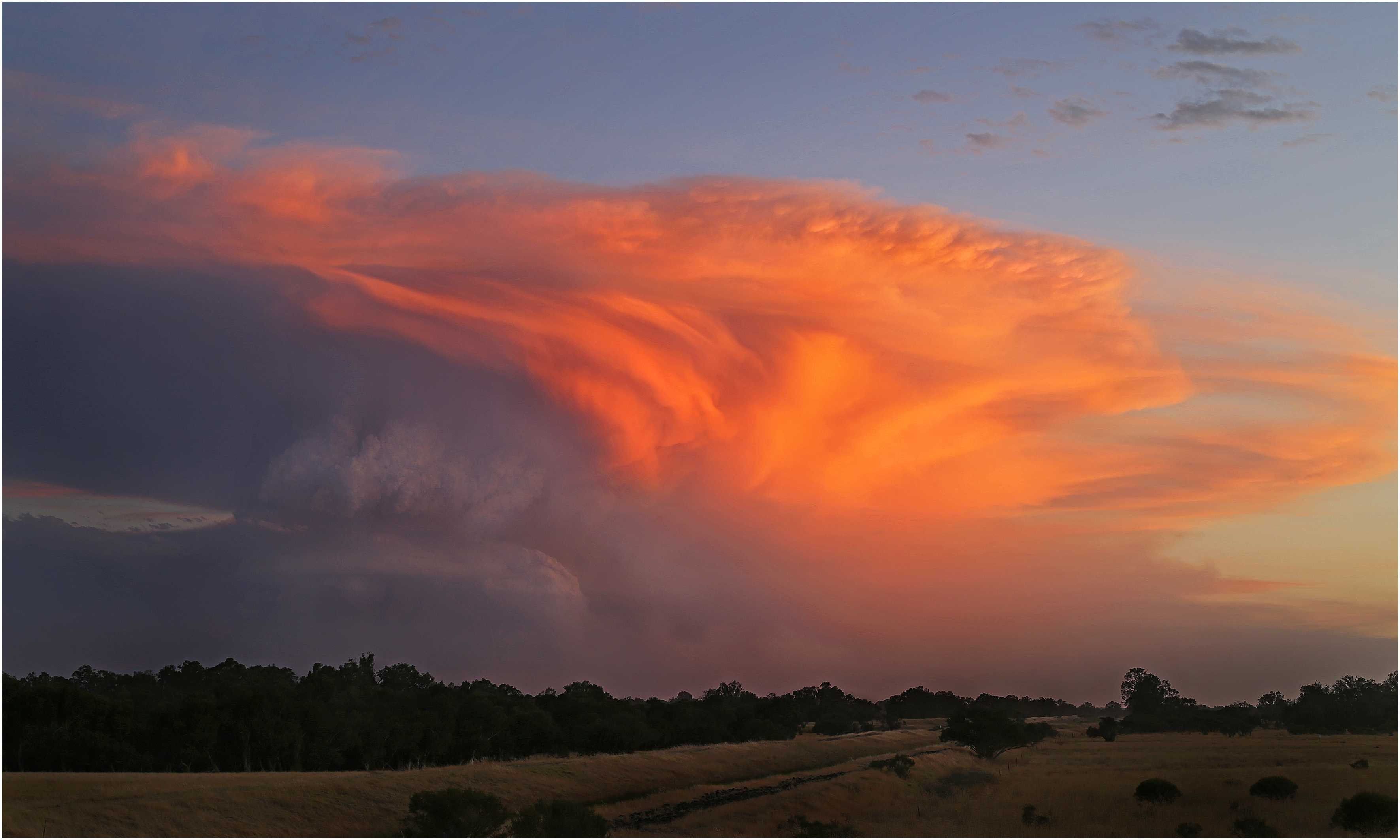
Cumulonimbus capillatus incus flammagenitus – Yarloop, Western Australia, Australia fire
Cumulonimbus is a heavy and dense cloud of considerable or strong vertical extent, in the form of a mountain or huge towers. At least part of its upper portion is usually smooth, fibrous or striated, and is nearly always flattened. Though the upper parts are often whitish in colour, in this case there is an orange glow due to the low angle of the setting Sun, which is no longer lighting the lower part of the cloud. In the photograph, the upper portion of the Cumulonimbus has the characteristic flattened, fibrous top of the species capillatus and the top has spread out in the shape of an anvil, which is the supplementary feature incus. As the origin of this cloud was a forest fire in Yarloop, Western Australia, Australia, some 65 km to the south-south-east of the camera, we may also use the designation flammagenitus. The ash content of the lower part of the cloud is clearly visible .
Links in the image description will highlight features on the image. Mouse over the features for more detail.
© Ben ClarkLakelands, Western Australia, AustraliaLatitude: 32° 28' 26'' SLongitude: 115° 47' 3'' E06 January 2016 1916 (Local Time)Camera direction: towards SSECL = 9, CM = 6, CH = 3Image P/S code: P.10.20Image I.D.: 5742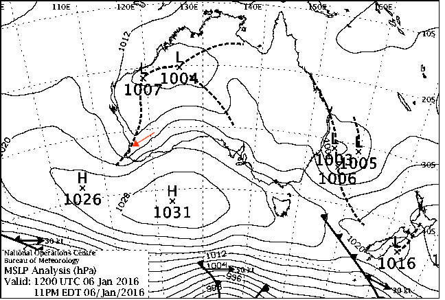
A large high pressure system in the Great Australian Bight was directing east-north-east to east-south-east winds over the area.
© Commonwealth of Australia 2016, Bureau of Meteorology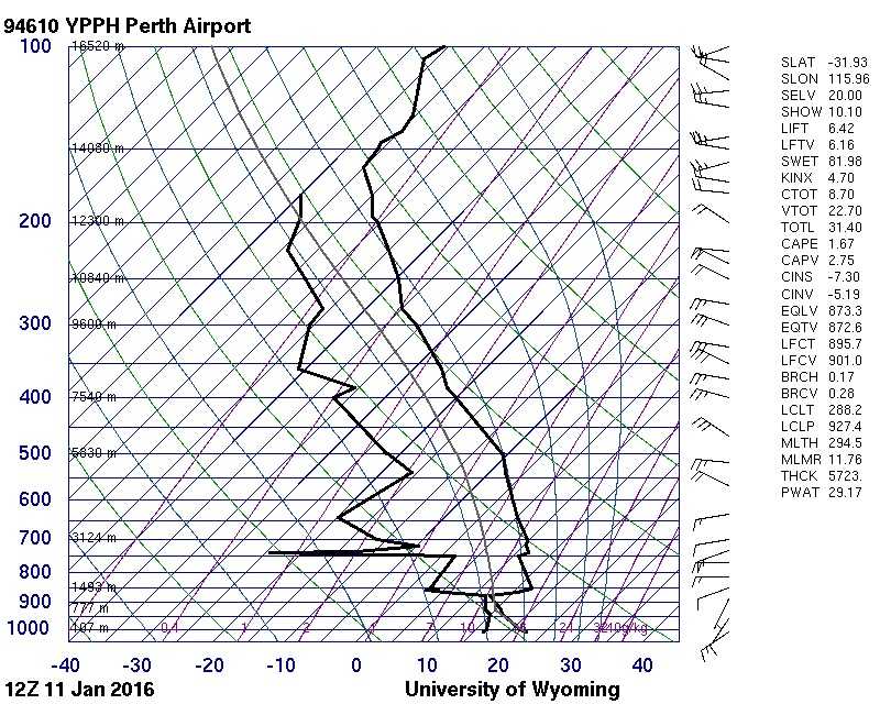
The sounding from Perth, Western Australia, Australia (WMO 94610), about 110 km to the north, shows a relatively moist layer below 880 hPa fed by a sea breeze and capped by a temperature inversion. At medium and upper levels the air is dry. Temperatures generated by the intensity of the forest fire were clearly sufficient to break down the inversion and allow vigorous convection to occur.
© University of Wyoming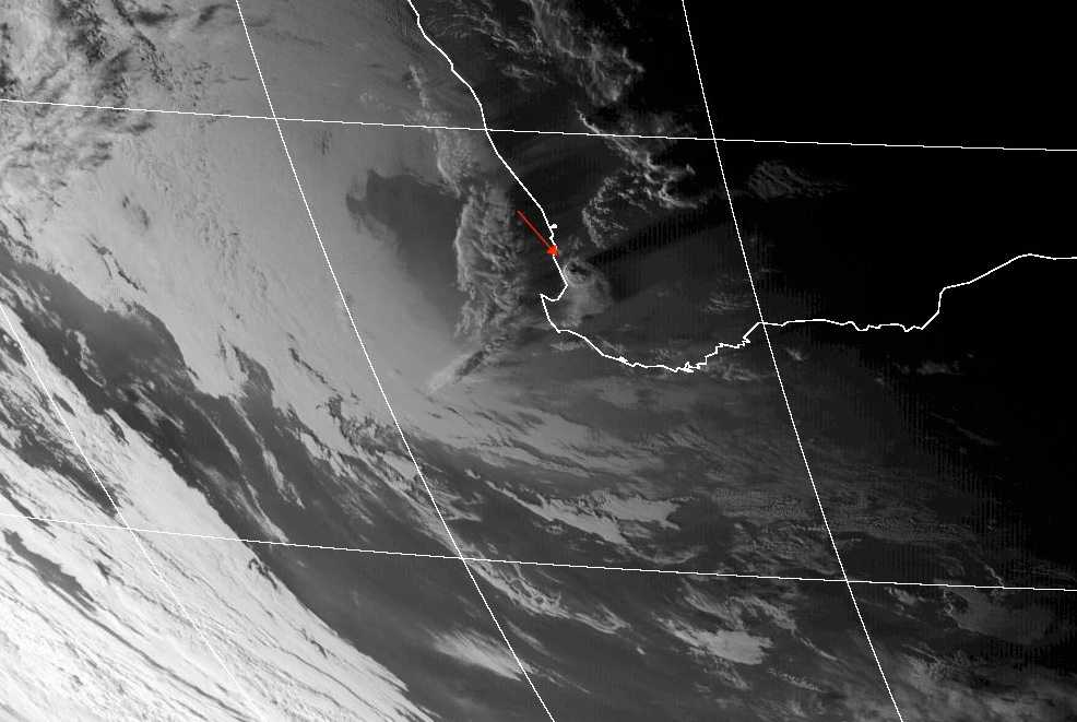
In this Himawari-8 channel 4 short-wave infrared image, the Cumulominbus appears symmetrical, with a two distinct areas of overshooting tops evident. The immense vertical extent of the Cumulonimbus can be gauged by the shadow it is casting to the east-north-east. The incus (anvil-shaped part of the top) can be seen spreading to the south-east and is also casting a shadow to the east-north-east. More Cumulonimbus cells can be seen to the north-east and cirriform cloud is visible offshore.
© Commonwealth of Australia 2016, Bureau of Meteorology / Japan Meteorological Agency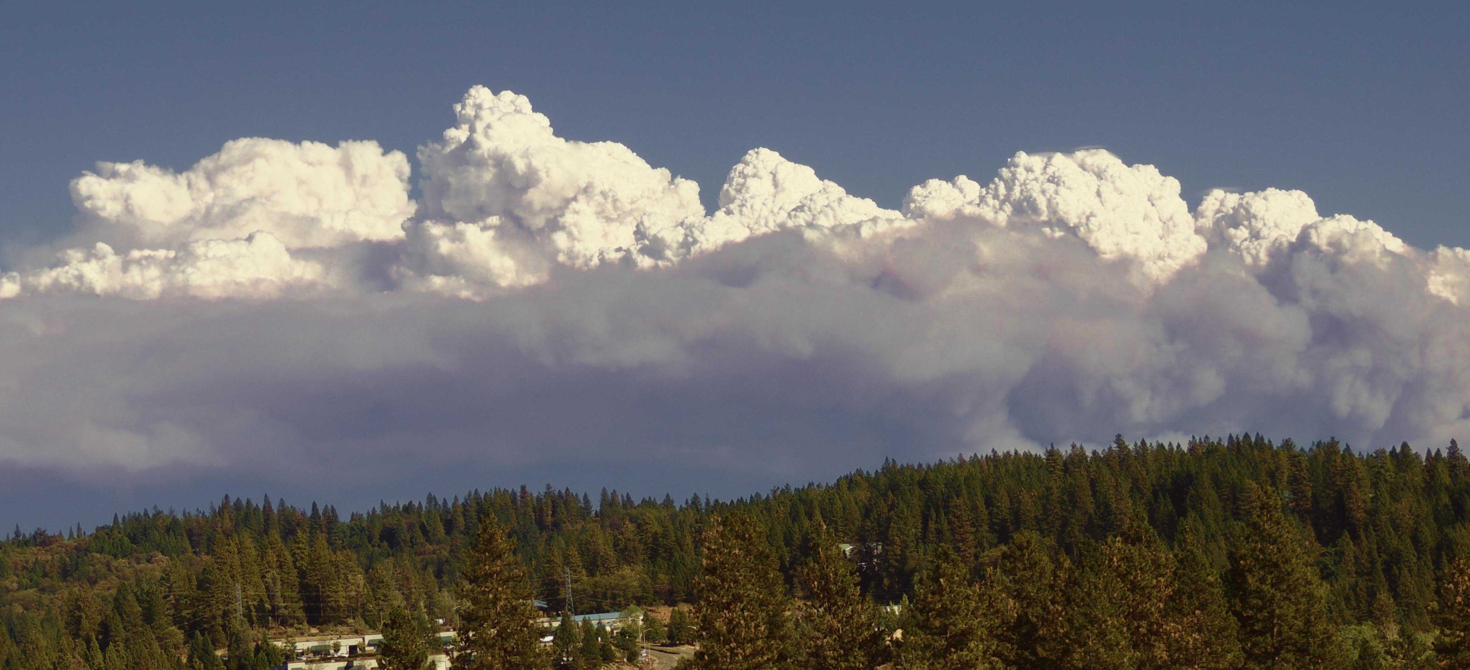
Cumulonimbus calvus pileus cumulogenitus flammagenitus
Cumulus and Cumulonimbus forming above the King Fire, Eldorado National Forest, California, USA.
Cumulonimbus generally results from the development and transformation of Cumulus. This can make it difficult to distinguish Cumulus congestus of great vertical extent from the first stage of Cumulonimbus – that is, the species calvus. If any of the sprouting upper parts are indistinct and flattened, the Cumulus has transitioned into Cumulonimbus calvus.
The cell on the left side has flattened and has the beginnings of an indistinct top. It is Cumulonimbus calvus, not capillatus, as the upper part does not have any cirriform parts of a clearly fibrous or striated structure.
The cell to the immediate right has sharply defined upper parts on its left side, but its back right edge has a domed appearance, just short of flattened. Cells to the right appear to be more recent Cumulus congestus that are in an earlier stage of their life cycle.
The accessory cloud pileus is superposed on cells at 1 and 2. This feature should not be mistaken for evidence of indistinct and flattened tops that have the appearance of a whitish mass without sharp outlines.
Interestingly, the cumuliform cloud has a slightly dirty appearance, indicating the presence of fine ash particles through its vertical extent.
Links in the image description will highlight features on the image. Mouse over the features for more detail.
© Beryl MoodyGlasson Way at Main Entrance Sierra Nevada Memorial Hospital, Grass Valley, CA 95945, United States of AmericaLatitude: 39° 13' 41'' NLongitude: 121° 2' 51'' W17 September 2014 1518 (Local Time)Camera direction: towards SECL = 3, CM = 0, CH = 0Image P/S code: S.10.20Image I.D.: 5743