© Michael Bruhn
Rosebud West, Victoria, Australia
Latitude: 38° 21' 50'' S
Longitude: 144° 52' 13'' E
29 May 2014 1313 (Local Time)
Camera direction: towards SW
Image P/S code: P.7.23
Image I.D.: 5841
CL = 4, CM = 0, CH = 0
-
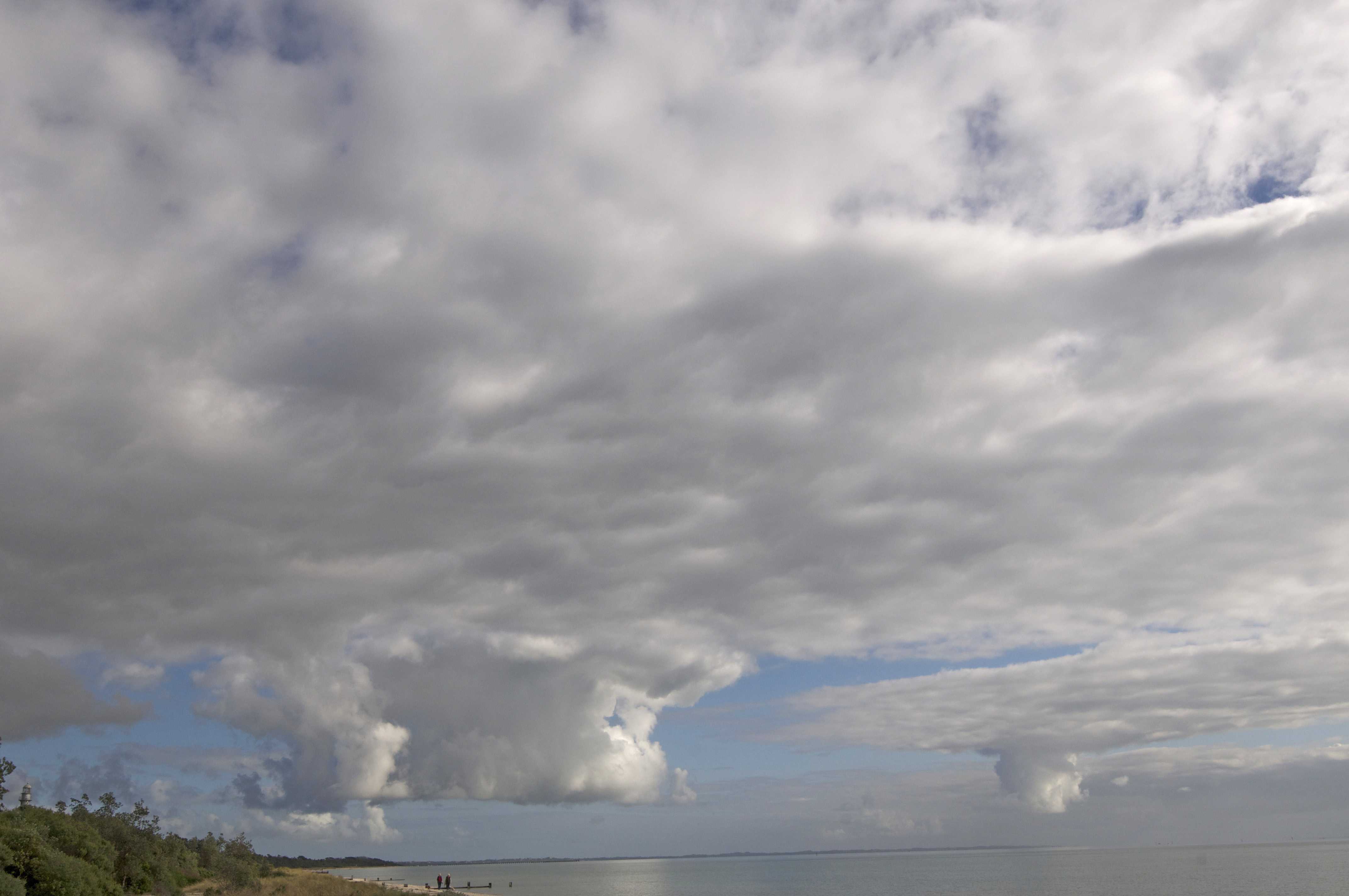
Stratocumulus cumulogenitus
In this photograph, isolated Cumulus cells have reached an inversion, where the tops are spreading downwind as a layer of Stratocumulus cumulogenitus. The Cumulus cells can be regarded as intermediate between the species mediocris and congestus, but tend towards the former. The Stratocumulus layer was relatively thin and short-lived, lasting only 30 minutes after each Cumulus spread out upon reaching the inversion layer. The Cumulus cell on the right-hand edge is decaying from the base up. There is Cumulus fractus and mediocris low on the horizon. The area was under the influence of a strengthening anticyclone.
Links in the image description will highlight features on the image. Mouse over the features for more detail.
© Michael BruhnRosebud West, Victoria, AustraliaLatitude: 38° 21' 50'' SLongitude: 144° 52' 13'' E29 May 2014 1313 (Local Time)Camera direction: towards SWCL = 4, CM = 0, CH = 0Image P/S code: P.7.23Image I.D.: 5841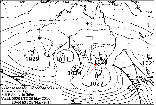
The synoptic chart from 0900 hours local time shows high pressure centred south of Tasmania, Australia. It was ridging northward and intensifying, stabilizing the atmosphere over the area. A weak cold front had passed through six hours earlier.
© Commonwealth of Australia 2014, Bureau of Meteorology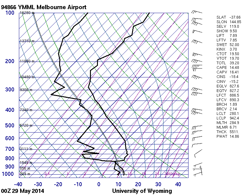
The sounding is from a site 60 km to the north-north-west and four hours prior to the photograph. Sounding modification identifies a dry adiabatic lapse rate from the surface to the base of the inversion at 830 hPa (1 800 m).
© University of Wyoming
Stratocumulus cumulogenitus homogenitus
This photograph shows how rising thermals from the power plants Prunéřov, Tušimice and Počerady in the Czech Republic have generated Cumulus congestus homogenitus clouds at 1, 2 and 3. These clouds have spread out to form Stratocumulus under an inversion, at a height of about 2 500 m. As the Stratocumulus has formed by the spreading of Cumulus, the mother-cloud term cumulogenitus applies. Furthermore, as the clouds formed as a consequence of human activity, the name homogenitus also applies. This cloud is therefore Stratocumulus cumulogenitus homogenitus. There is a slight reduction of visibility on the horizon due to haze and, downwind from the chimneys, smoke resulting from additional particulate matter from the chimneys.
Links in the image description will highlight features on the image. Mouse over the features for more detail.
© Karlona PlskovaJáchymov, Czech RepublicLatitude: 50° 23' 45'' NLongitude: 12° 58' 5'' E18 January 2016 1118 (Local Time)Camera direction: towards SECL = 4, CM = 3, CH = 0Image P/S code: S.7.23Image I.D.: 4892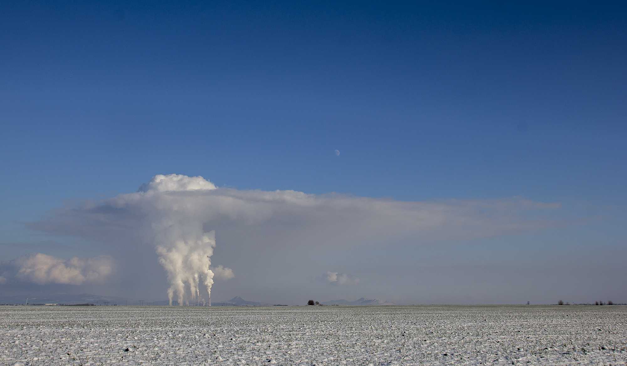
Stratocumulus cumulogenitus homogenitus
A Cumulus congestus homogenitus cloud has formed here above the Mělník power station in the Czech Republic. The name “homogenitus” denotes that the cloud formed as a direct result of human activity; in this case, as a result of the rising thermals from the power station chimneys condensing in the cold surrounding air.
Although the Cumulus top extends to a considerable height, some cloud has spread out under a temperature inversion at a height of about 2 000 m to form a layer of Stratocumulus. As the Stratocumulus was formed by the spreading of Cumulus, the mother-cloud name cumulogenitus applies. In addition, because this cloud also resulted from human activity, the name homogenitus applies here too. This cloud is therefore Stratocumulus cumulogenitus homogenitus. In the background, there is some natural Cumulus mediocris and Cumulus congestus.
Links in the image description will highlight features on the image. Mouse over the features for more detail.
© Karlona PlskovaSmolnice, Czech RepublicLatitude: 50° 19' 34'' NLongitude: 13° 51' 57'' E18 January 2016 1440 (Local Time)Camera direction: towards SECL = 4, CM = 0, CH = 0Image P/S code: S.7.23Image I.D.: 4893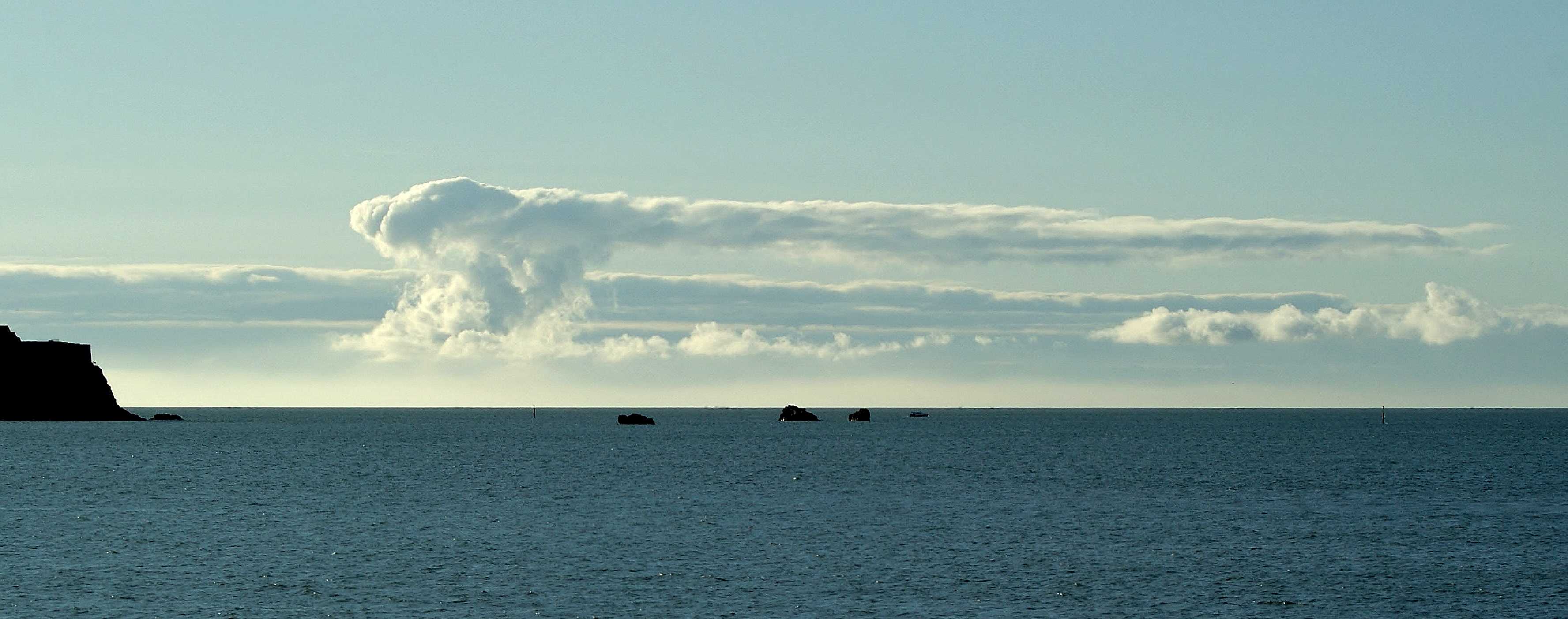
Stratocumulus cumulogenitus
This image shows a side view of Stratocumulus cloud formed by the spreading out of Cumulus, identifying it as cumulogenitus. The cloud spread out as ascending currents within the Cumulus reached a strong temperature inversion at about 1 600 m (5 000 ft). Also visible are further small amounts of Cumulus with a base of about 500 m (1 500 ft); a more extensive layer of Stratocumulus can be seen in the background.
Links in the image description will highlight features on the image. Mouse over the features for more detail.
© Paul AkedFirst Tower, St Helier, JerseyLatitude: 49° 11' 36'' NLongitude: 2° 7' 42'' W12 January 2012 1158 (Local Time)Camera direction: towards SSWCL = 4, CM = 0, CH = 0Image P/S code: S.7.23 1Image I.D.: 5138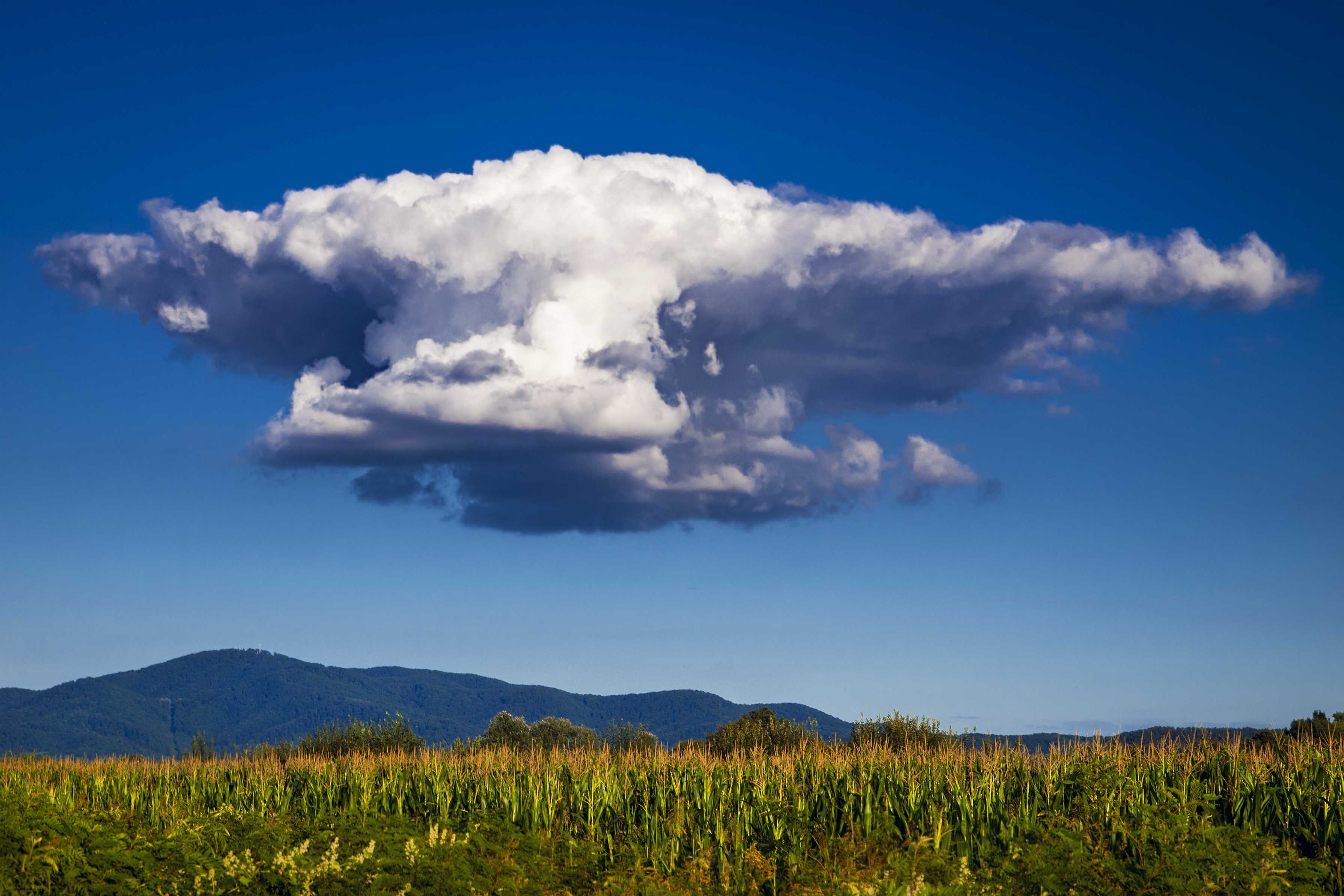
Stratocumulus cumulogenitus
This photograph shows the development of Cumulus cloud over a field of maize. The vertical growth has stopped abruptly beneath a temperature inversion, which has caused the cloud to spread out, thus transforming the cloud into a layer of Stratocumulus. As the mother-cloud is Cumulus, we may add the descriptor cumulogenitus. Small pieces of Cumulus fractus can also be seen near the base of the cloud at 2 and 3.
Links in the image description will highlight features on the image. Mouse over the features for more detail.
© Ivica BrlićDavor, CroatiaLatitude: 45° 7' 40'' NLongitude: 17° 30' 44'' E17 August 2014 1824 (Local Time)CL = 4, CM = 0, CH = 0Image P/S code: S.7.23 5Image I.D.: 5419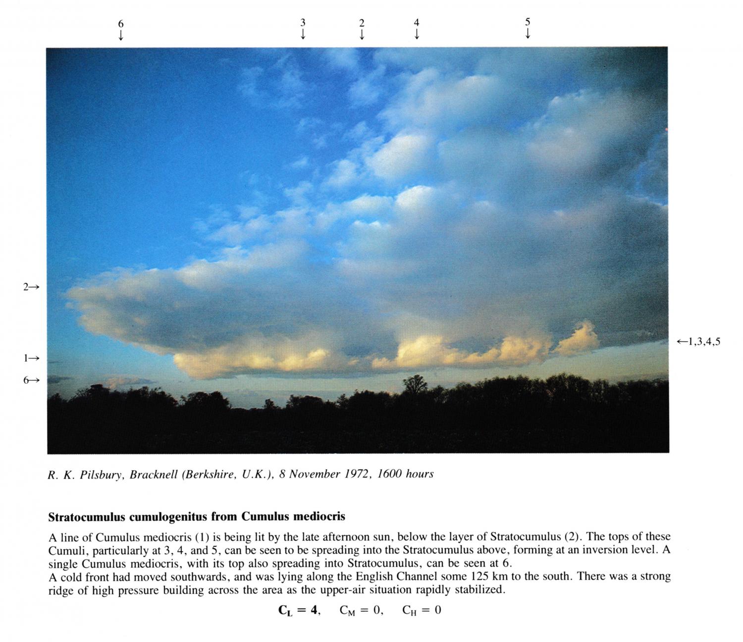
Stratocumulus cumulogenitus from Cumulus mediocris
A line of Cumulus mediocris is being lit by the late afternoon sun, below the layer of Stratocumulus. The tops of these Cumuli, particularly at 3, 4, and 5, can be seen to be spreading into the Stratocumulus above, forming at an inversion level. A single Cumulus mediocris, with its top also spreading into Stratocumulus, can be seen at 6.
A cold front had moved southwards, and was lying along the English Channel some 125 km to the south. There was a strong ridge of high pressure building across the area as the upper-air situation rapidly stabilized.
Links in the image description will highlight features on the image. Mouse over the features for more detail.
© R.K. PilsburyBracknell, Berkshire, United Kingdom of Great Britain and Northern IrelandLatitude: 51° 24' 58'' NLongitude: 0° 45' 14'' W08 November 1972 1600 (Local Time)Camera direction: towards ECL = 4, CM = 0, CH = 0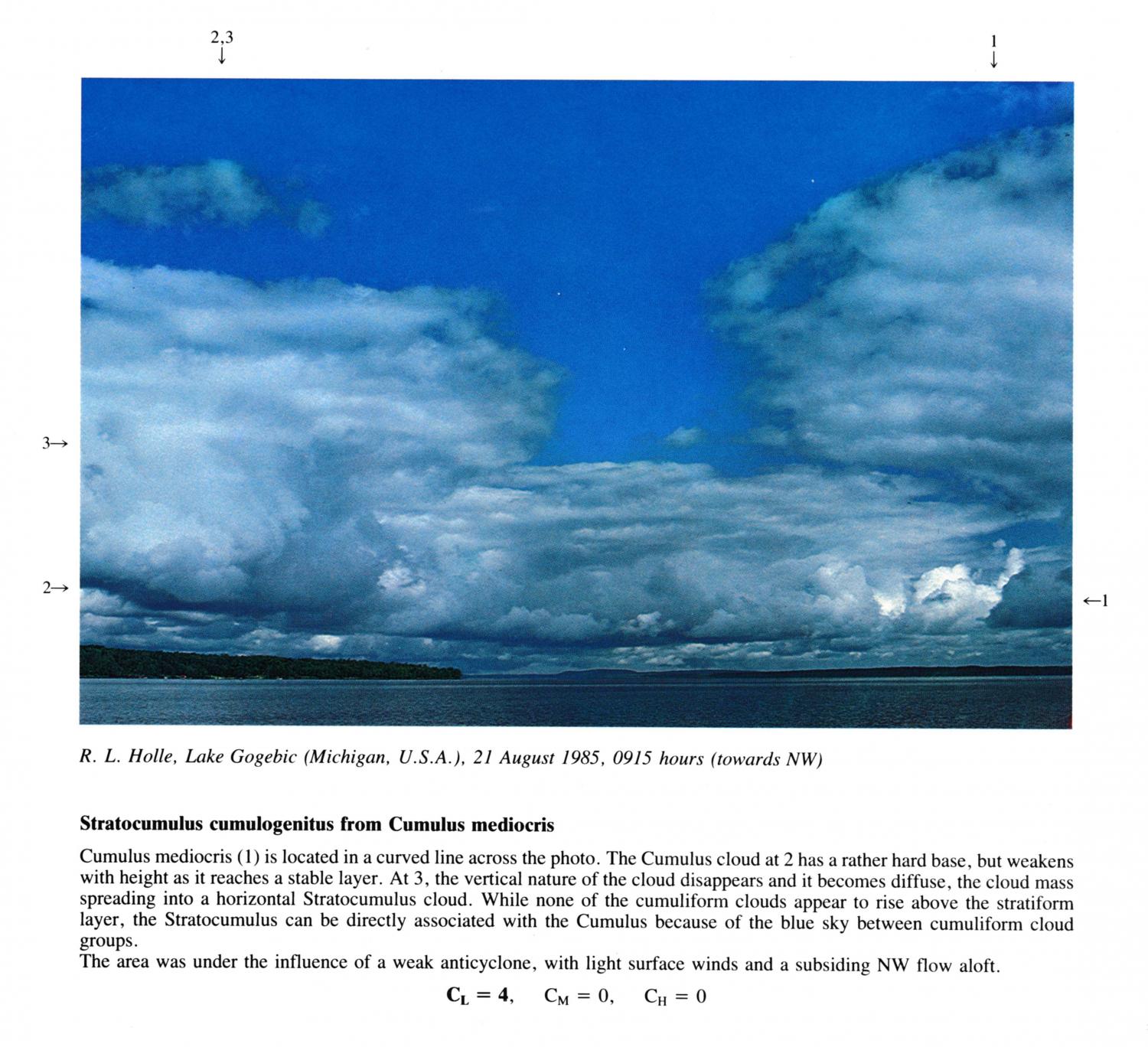
Stratocumulus cumulogenitus from Cumulus mediocris
Cumulus mediocris is located in a curved line across the photo. The Cumulus cloud at 2 has a rather hard base, but weakens with height as it reaches a stable layer. At 3, the vertical nature of the cloud disappears and it becomes diffuse, the cloud mass spreading into a horizontal Stratocumulus cloud. While none of the cumuliform clouds appear to rise above the stratiform layer, the Stratocumulus can be directly associated with the Cumulus because of the blue sky between cumuliform cloud groups.
The area was under the influence of a weak anticyclone, with light surface winds and a subsiding NW flow aloft.
Links in the image description will highlight features on the image. Mouse over the features for more detail.
© R.L. HolleLake Gogebic, Michigan, United States of AmericaLatitude: 46° 30' 39'' NLongitude: 89° 34' 48'' W21 August 1985 0915 (Local Time)Camera direction: towards NWCL = 4, CM = 0, CH = 0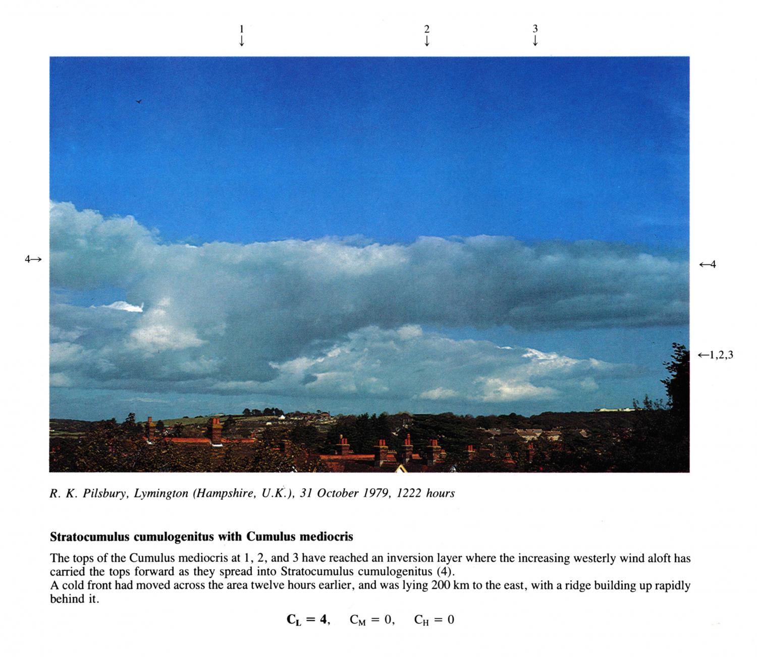
Stratocumulus cumulogenitus with Cumulus mediocris
The tops of the Cumulus mediocris at 1, 2, and 3 have reached an inversion layer where the increasing westerly wind aloft has carried the tops forward as they spread into Stratocumulus cumulogenitus. A cold front had moved across the area twelve hours earlier, and was lying 200 km to the east, with a ridge building up rapidly behind it.
Links in the image description will highlight features on the image. Mouse over the features for more detail.
© R.K. PilsburyLymington, Hampshire, United Kingdom of Great Britain and Northern IrelandLatitude: 50° 45' 31'' NLongitude: 1° 32' 31'' W31 October 1979 1222 (Local Time)CL = 4, CM = 0, CH = 0