© Michael Bruhn
Aspendale Gardens, Victoria, Australia
Latitude: 38° 1' 29'' S
Longitude: 145° 6' 48'' E
17 December 2010 1908 (Local Time)
Camera direction: towards WNW
Image P/S code: P.8.2
Image I.D.: 5873
CL = 6, CM = 3, CH = 9
-
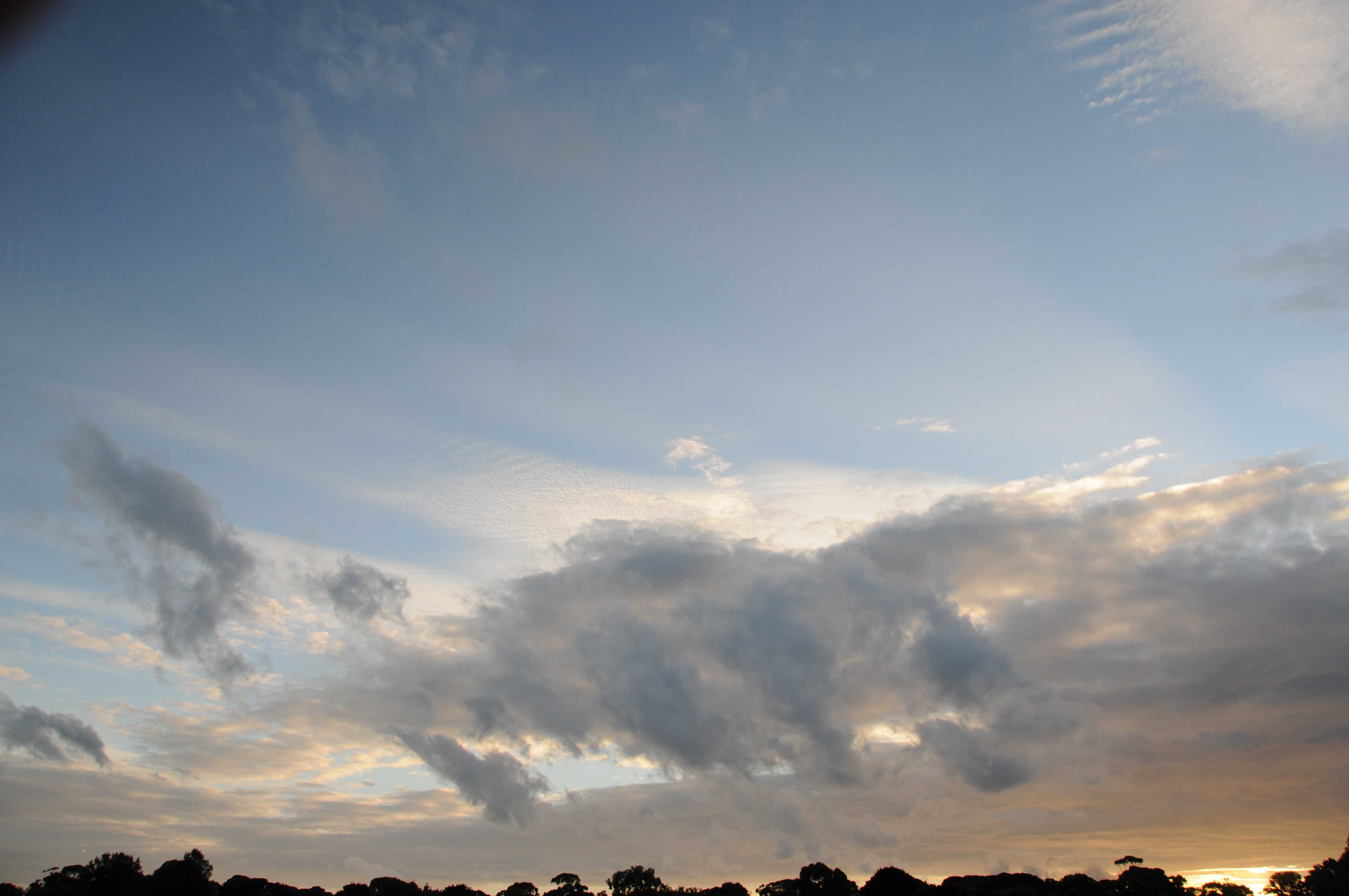
Stratus fractus of dry weather
Stratus is generally a grey layer of cloud with a fairly uniform base, but sometimes it appears in the form of ragged patches. In this photograph, the Stratus is dark grey and has the appearance of irregular, ragged (fractured) shreds of cloud (seen at 1, 2 and 3); the outlines were changing quickly and ceaselessly. These characteristics define the species fractus. Furthermore, because the cloud was not caused by precipitation, it is Stratus fractus of good weather. It should not be confused with Cumulus fractus, which is whiter and denser. Stratus fractus also shows less vertical development, as it forms mainly due to turbulence, rather than thermal convection. Also visible in the image are a layer of Altocumulus stratiformis and patches of Cirrocumulus.
Links in the image description will highlight features on the image. Mouse over the features for more detail.
© Michael BruhnAspendale Gardens, Victoria, AustraliaLatitude: 38° 1' 29'' SLongitude: 145° 6' 48'' E17 December 2010 1908 (Local Time)Camera direction: towards WNWCL = 6, CM = 3, CH = 9Image P/S code: P.8.2Image I.D.: 5873
The synoptic chart shows a trough of low pressure extending north through Victoria from an area south of Tasmania, Australia. The associated cold front had passed over the location of the photograph a few hours before the photograph was taken.
© Commonwealth of Australia 2010, Bureau of Meteorology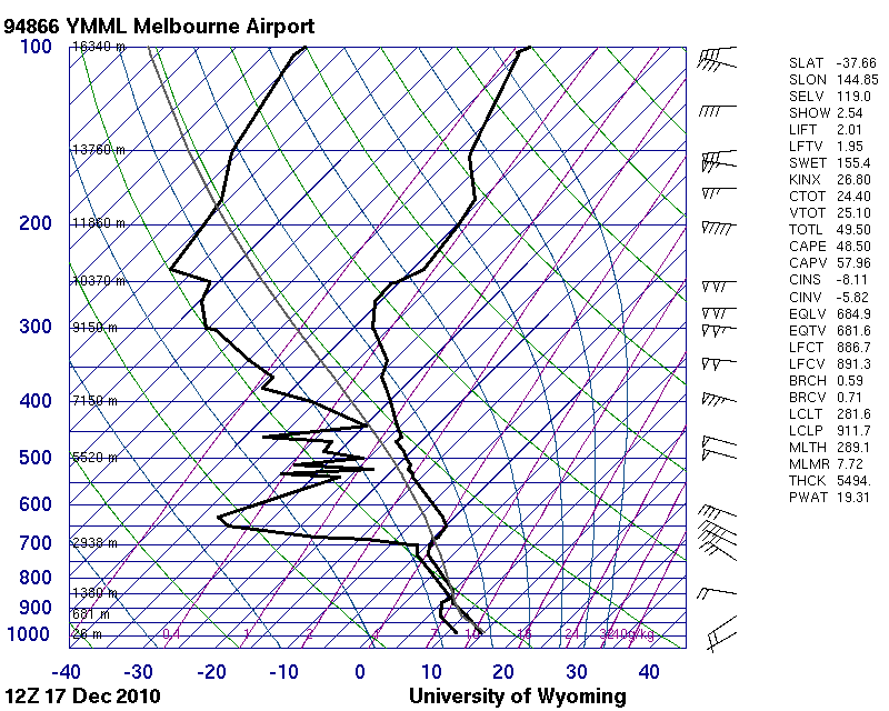
The sounding from Melbourne Airport, Victoria, Australia (WMO 94866) was taken behind a cold front and after the time of the photograph. It shows an unstable atmosphere from the surface to 700 hPa, with a moist zone from 850 to 700 hPa. Of note is the 15- to 20-kt wind close to the surface.
© University of Wyoming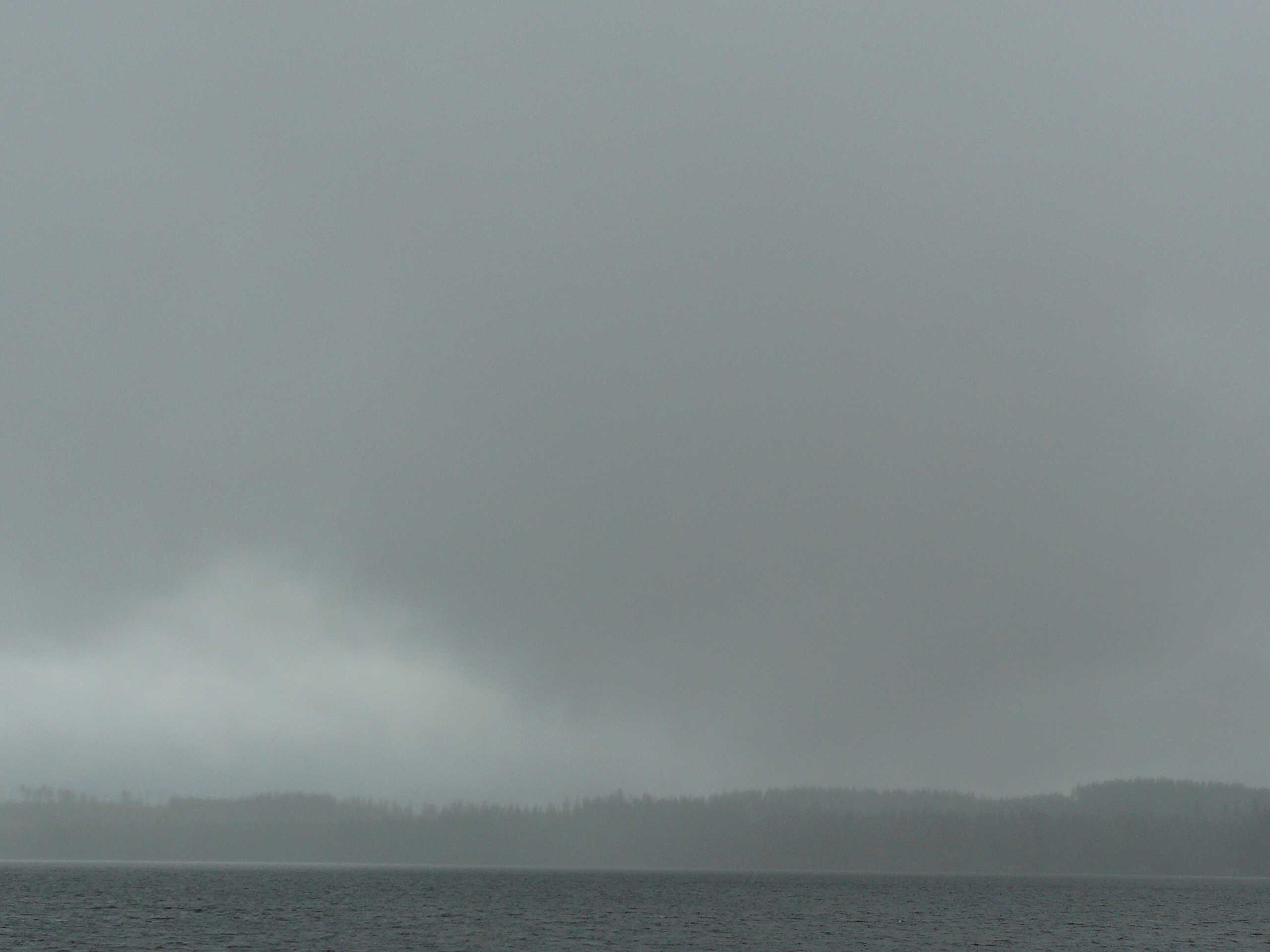
Stratus fractus with praecipitatio
This image shows the general grey colour associated with Stratus. Sometimes Stratus shows the ragged or irregular edges of the species fractus, as seen in this image. Fractus can be a transition stage in the formation of Stratus, which in this case was merging with a higher-based Stratus nebulosus, seen as a lighter shade of grey in the distance. The opaque nature of the cloud defines the variety opacus, while the supplementary feature praecipitatio can be seen as drizzle, which was reducing visibility to an estimated 3 km.
Links in the image description will highlight features on the image. Mouse over the features for more detail.
© Jarmo KoistinenSavonlinna, FinlandLatitude: 61° 52' 32'' NLongitude: 28° 51' 56'' E21 July 2008 0835 (Local Time)Camera direction: towards SWCL = 6, CM = /, CH = /Image P/S code: S.8.2 1Image I.D.: 5497