© Stephen Burt
Stratfield Mortimer, en las inmediaciones de Reading, Berkshire RG7 (Reino Unido de Gran Bretaña e Irlanda del Norte)
Latitud: 51° 22' 12'' N
Longitud: 1° 2' 24'' W
10 July 2010 2040 (Hora local)
Dirección de la cámara: hacia el noroeste
Código P/S: P.4.12
N.º imagen: 5925
CL = 0, CM = 8, CH = 0
-
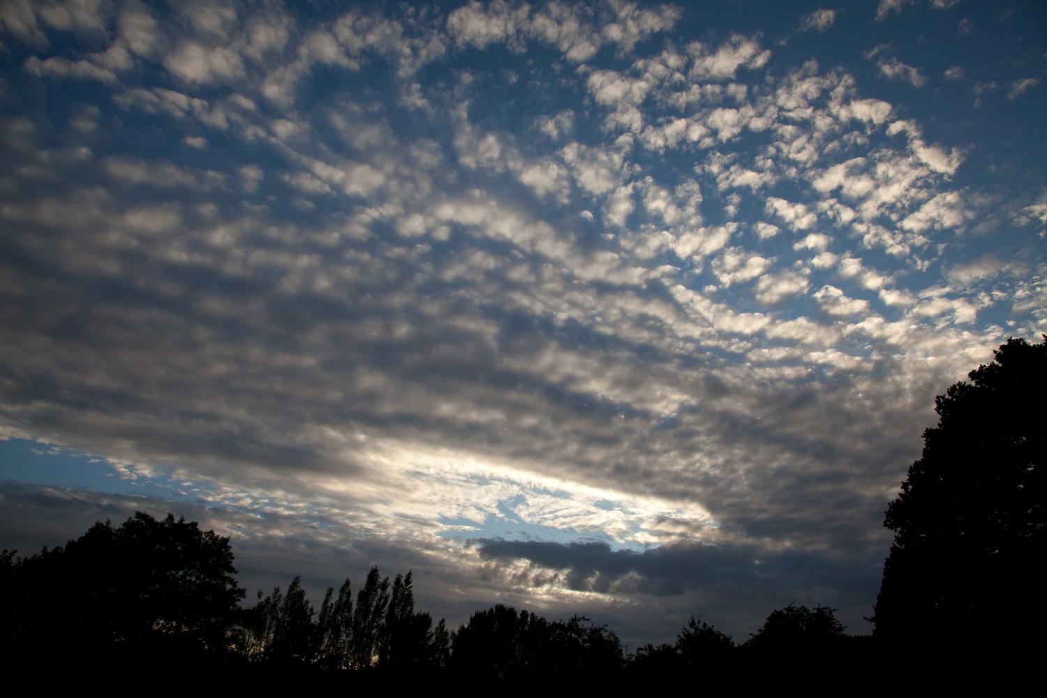
Altocumulus floccus duplicatus radiatus en expansión
El presente es el borde de ataque de una banda de dos capas de Altocumulus en expansión, que se engrosó rápidamente y aumentó en cantidad.
El Altocumulus más bajo es de color gris oscuro (por encima de los árboles) y está compuesto de penachos cumuliformes con bases bien definidas en la mayoría de las partes. A su izquierda, las bases se disipan y se tornan rasgadas.
La capa más alta es de color gris neutro y blanquecina en las partes más finas. Los elementos en esta capa se fusionan en largas líneas que parecen converger hacia un punto cercano al horizonte. Se trata de la variedad radiatus.
Los enlaces en la descripción de la imagen resaltarán elementos de la misma. Para más información, pase el cursor por encima.
© Stephen BurtStratfield Mortimer, en las inmediaciones de Reading, Berkshire RG7 (Reino Unido de Gran Bretaña e Irlanda del Norte)Latitud: 51° 22' 12'' NLongitud: 1° 2' 24'' W10 July 2010 2040 (Hora local)Dirección de la cámara: hacia el noroesteCL = 0, CM = 8, CH = 0Código P/S: P.4.12N.º imagen: 5925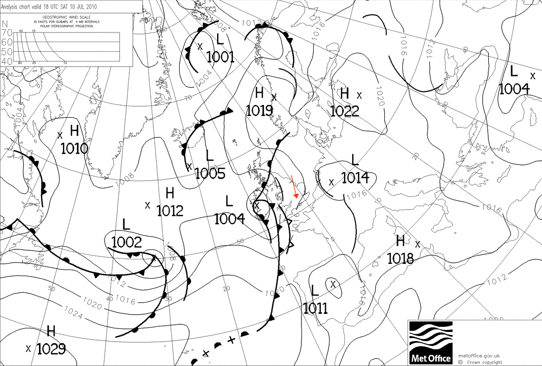
Una depresión de onda abierta y poco profunda se desarrolló sobre el oeste de las islas británicas en el momento en que se tomó la fotografía, muy cerca de otra onda que se desarrollaba sobre el este de Francia.
© Derechos de autor de la Corona británica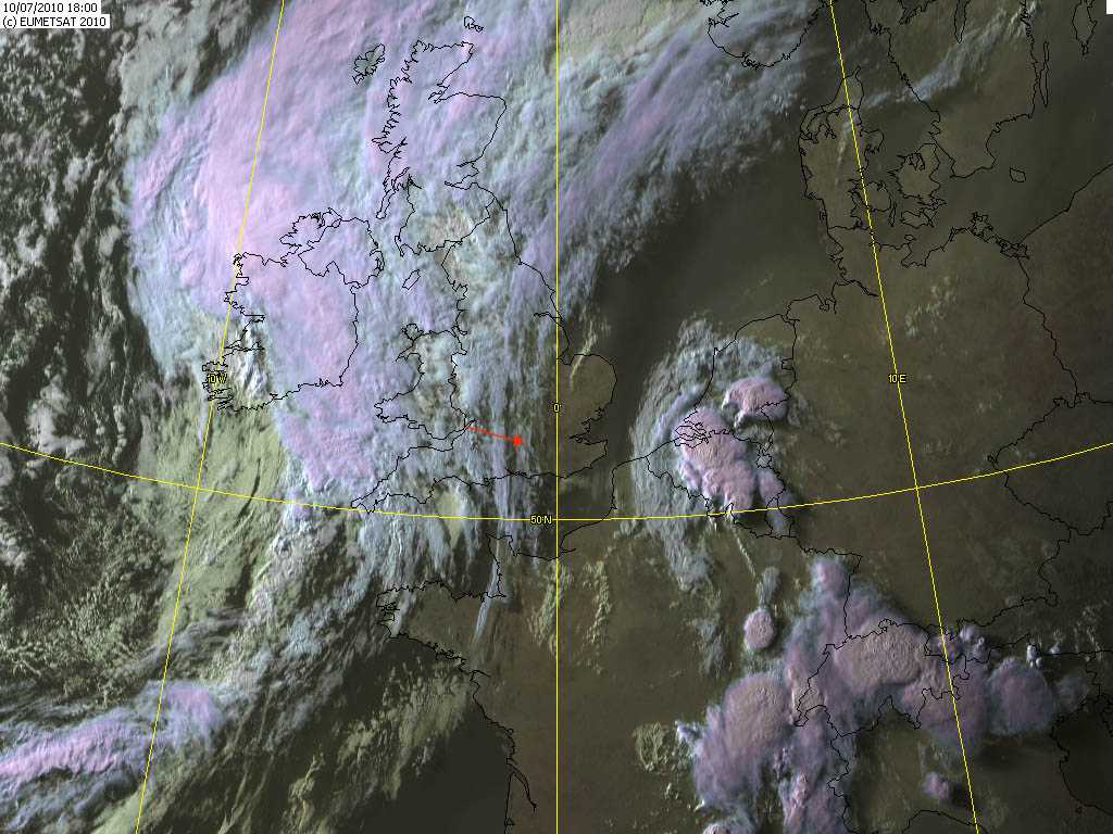
Los Cirrus que precedieron al Altocumulus pueden apreciarse al este de Stratfield Mortimer, Inglaterra (Reino Unido). El borde de ataque del Altocumulus en expansión se encuentra unos 50 km al oeste.
© EUMETSAT, 2010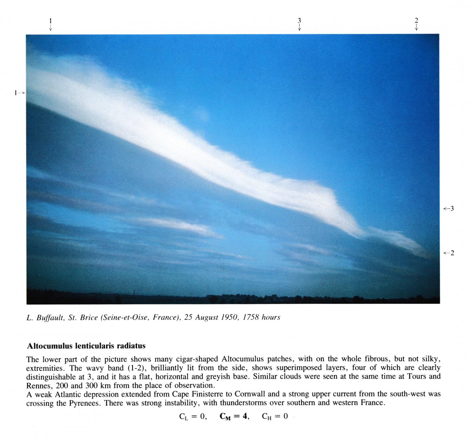
Altocumulus lenticularis radiatus
The lower part of the picture shows many cigar-shaped Altocumulus patches, with on the whole fibrous, but not silky, extremities. The wavy band (1 - 2), brilliantly lit from the side, shows superimposed layers, four of which are clearly distinguishable at 3, and it has a flat, horizontal and greyish base. Similar clouds were seen at the same time at Tours and Rennes, 200 and 300 km from the place of observation. A weak Atlantic depression extended from Cape Finisterre to Cornwall and a strong upper current from the south-west was crossing the Pyrenees. There was strong instability, with thunderstorms over southern and western France.
Los enlaces en la descripción de la imagen resaltarán elementos de la misma. Para más información, pase el cursor por encima.
© L. BuffaultSaint-Brice-sous-Forêt, Seine-et-Oise, FranceLatitud: 48° 59' 58'' NLongitud: 2° 21' 22'' E25 August 1950 1758 (Hora local)CL = 0, CM = 4, CH = 0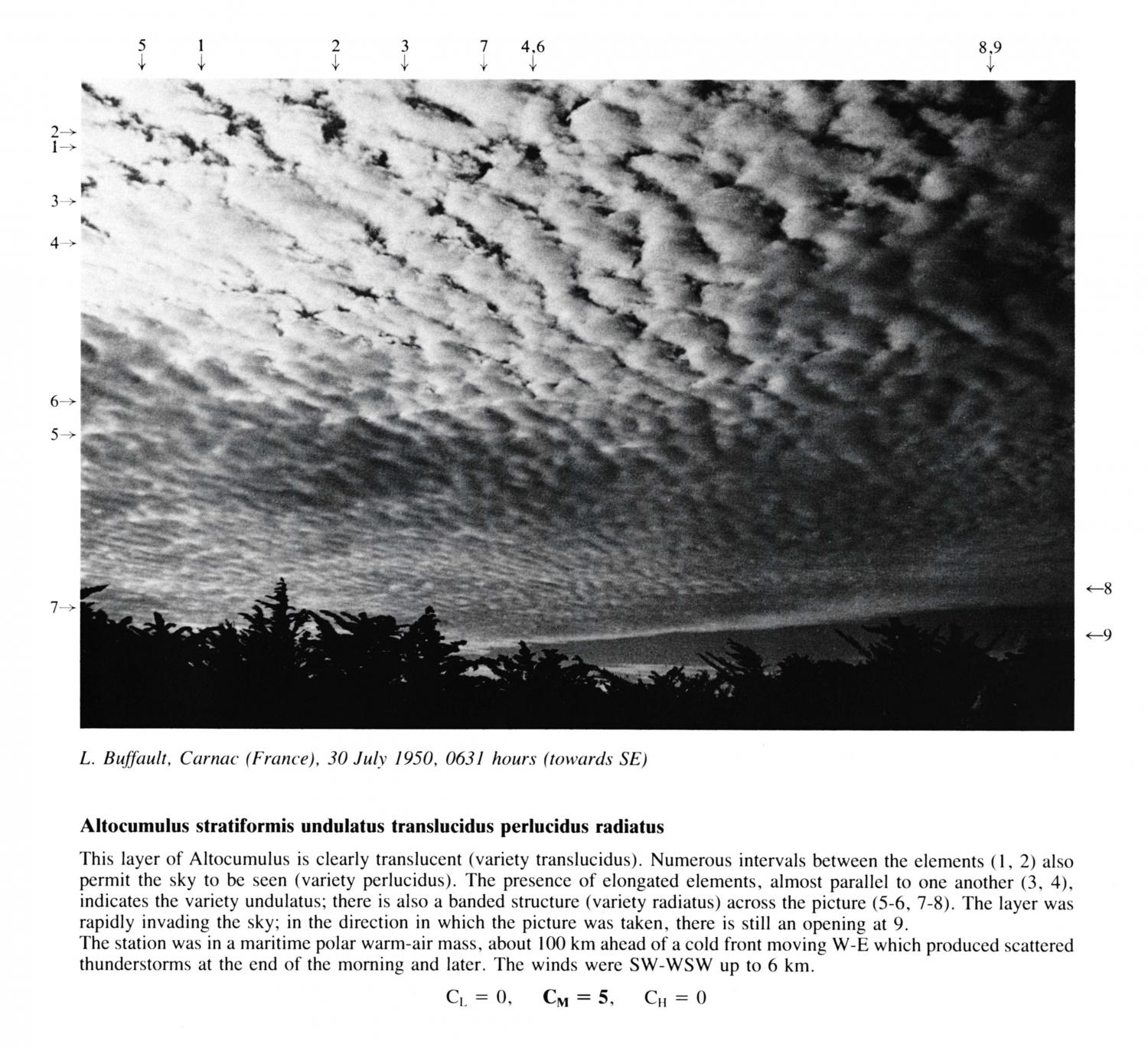
Altocumulus stratiformis undulatus translucidus perlucidus radiatus
This layer of Altocumulus is clearly translucent (variety translucidus). Numerous intervals between the elements 1 and 2 also permit the sky to be seen (variety perlucidus). The presence of elongated elements, almost parallel to one another at 3 and 4, indicates the variety undulatus; there is also a banded structure (variety radiatus) across the picture at 5, 6, 7 and 8. The layer was rapidly invading the sky; in the direction in which the picture was taken, there is still an opening at 9. The station was in a maritime polar warm-air mass, about 100 km ahead of a cold front moving W-E which produced scattered thunderstorms at the end of the morning and later. The winds were SW-WSW up to 6 km.
Los enlaces en la descripción de la imagen resaltarán elementos de la misma. Para más información, pase el cursor por encima.
© L. BuffaultCarnac, FranceLatitud: 47° 35' 5'' NLongitud: 3° 4' 40'' W30 July 1950 0631 (Hora local)Dirección de la cámara: hacia el suresteCL = 0, CM = 5, CH = 0