© Martin Gudd
Bad Kreuznach, Germany
Latitude: 49° 50' 39'' N
Longitude: 7° 50' 32'' E
04 November 2015 1618 (Local Time)
Camera direction: towards W
Image P/S code: P.8.5
Image I.D.: 4721
CL = 6, CM = 3, CH = 0
-
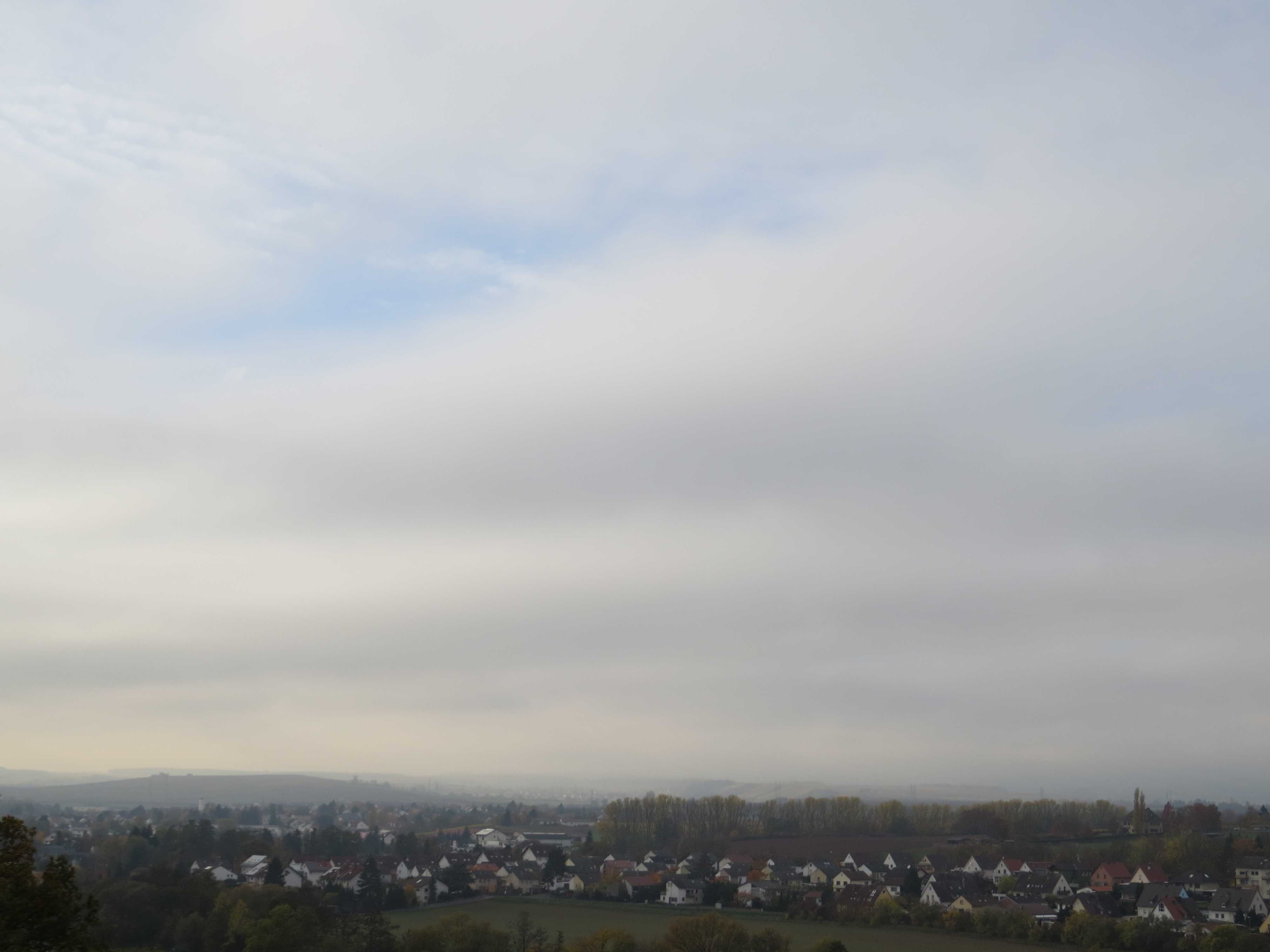
Stratus undulatus
A few minutes before the photograph was taken, a continuous layer of Stratus (which had been fog until noon) broke up and lifted into patches of Stratus. The patches in the image have a wave-like structure, which identifies the variety undulatus. Though the undulations resemble Stratocumulus undulatus, close observation of their development confirmed they are Stratus undulatus, a variety which occurs infrequently. As further evidence, the cloud base is relatively low and higher ground to the west remains shrouded in fog. In the upper part of the picture, some Altocumulus cloud is visible.
Links in the image description will highlight features on the image. Mouse over the features for more detail.
© Martin GuddBad Kreuznach, GermanyLatitude: 49° 50' 39'' NLongitude: 7° 50' 32'' E04 November 2015 1618 (Local Time)Camera direction: towards WCL = 6, CM = 3, CH = 0Image P/S code: P.8.5Image I.D.: 4721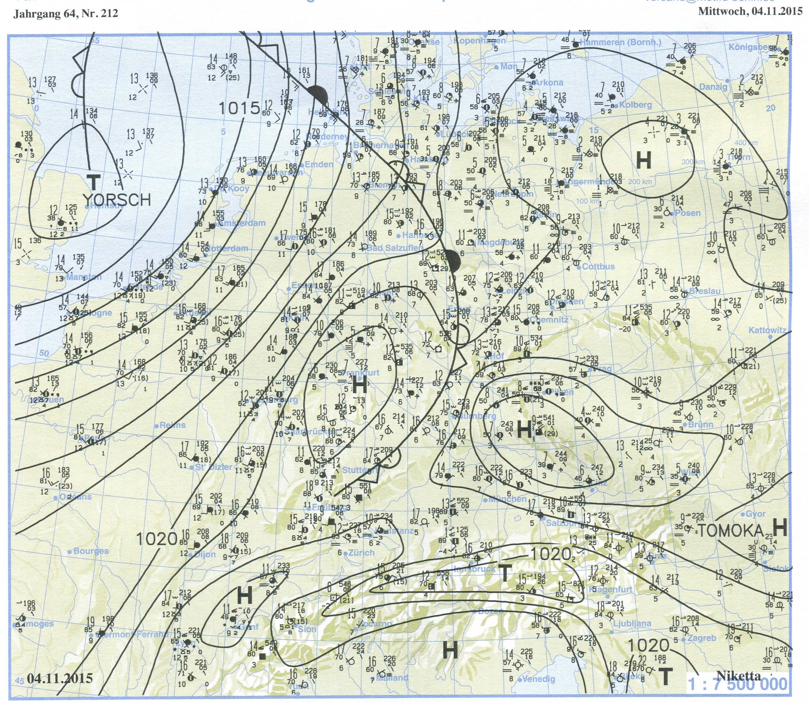
This 1200 UTC surface chart (note the 1 hPa isobar interval) from about three hours before the photograph shows two centres of high pressure over central Europe, where fog lingered in the valleys for several days. A weak front had just passed over the area from the south-west, bringing an increase in wind strength and a slow breakdown of the temperature inversion.
© Verein Berliner Wetterkarte e.V.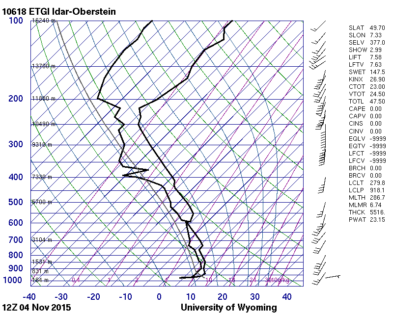
The 1200 UTC sounding from Idar-Oberstein, Germany (WMO 10618), 40 km to the west-south-west of the photograph location, shows a low-level temperature inversion of 6 °C between the surface and 350 m.
© University of Wyoming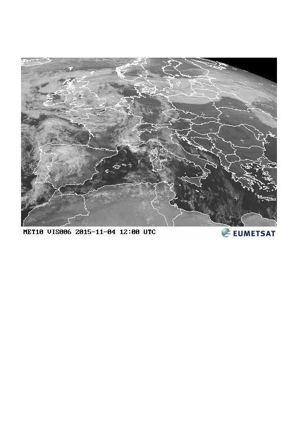
This satellite image, taken three hours before the photograph, shows fog lingering in the valleys of western central Germany. A weak front is approaching from the south-west, bringing middle- and high-level cloud to the area.
© EUMETSAT, 2015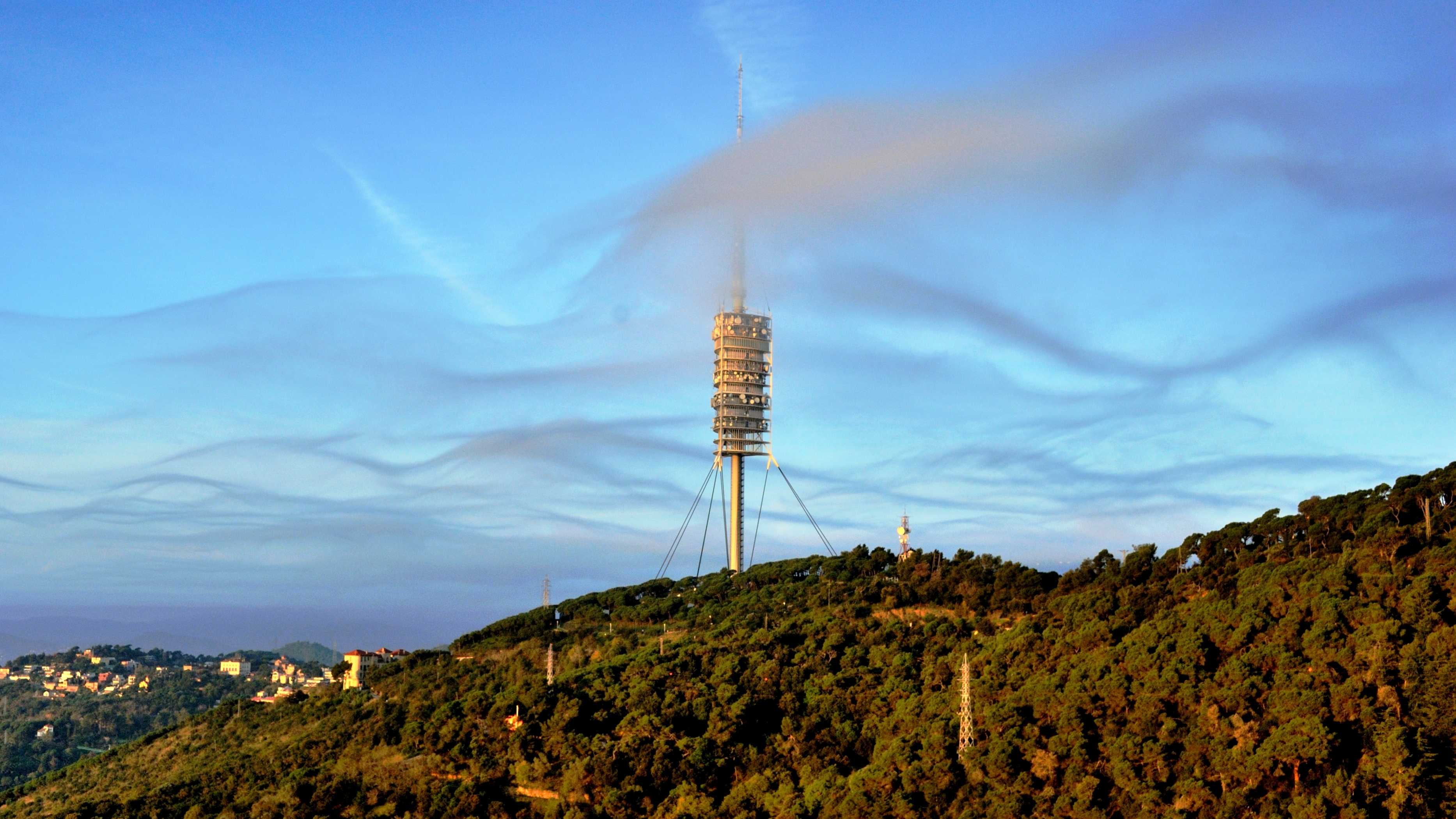
Stratus undulatus near Barcelona, Spain
Sometimes Stratus appears in the form of irregular patches. In this image, the irregular patches or wisps of cloud are showing prominent undulations (1 and 2); hence, they are designated as being of the variety undulatus. This is a comparatively rare form of Stratus. The local topography is in the range of 300 to 500 m above sea level, while the nearby sounding (see upper-air sounding) shows an inversion of 3 °C at about 1 000 m. From the wisp of cloud in front of the tower, we may estimate its height to be about 200 m above ground level. It is likely the undulations are the result of the forced ascent and descent of air over the hills, beneath the capping inversion. At the top of the image, spreading aircraft contrails can be seen at 4 and 5.
Links in the image description will highlight features on the image. Mouse over the features for more detail.
© Alfons PuertasVallvidrera, Barcelona, SpainLatitude: 41° 25' 6'' NLongitude: 2° 7' 27'' E20 November 2014 1115 (Local Time)Camera direction: towards WCL = 6, CM = 0, CH = 2Image P/S code: S.8.5 1Image I.D.: 5481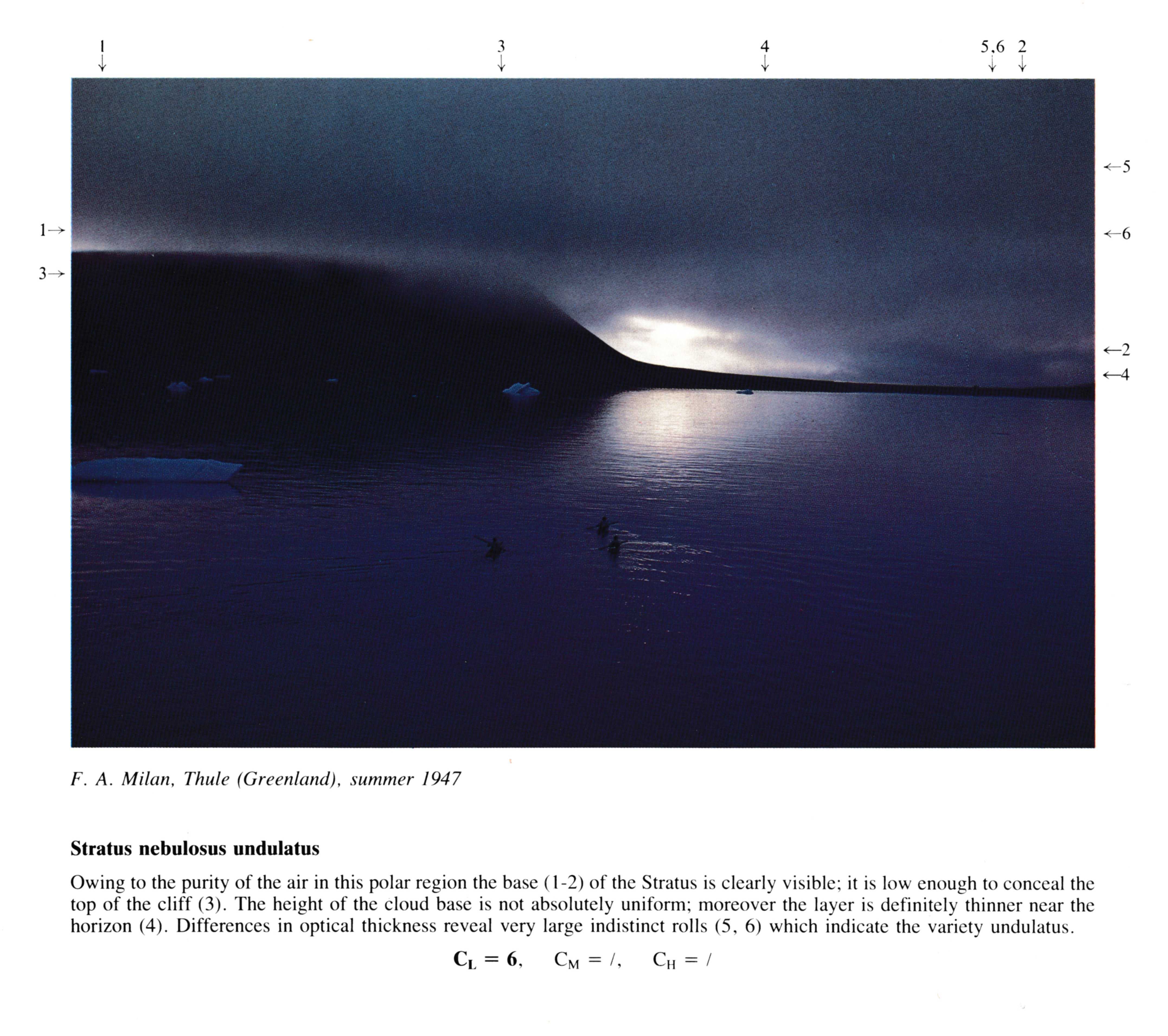
Stratus nebulosus undulatus
(NB: Summer 1947: date and hour estimated)
Owing to the purity of the air in this polar region the base at 1 - 2 of the Stratus is clearly visible; it is low enough to conceal the top of the cliff. The height of the cloud base is not absolutely uniform; moreover the layer is definitely thinner near the horizon. Differences in optical thickness reveal very large indistinct rolls at 5, 6 which indicate the variety undulatus.
Links in the image description will highlight features on the image. Mouse over the features for more detail.
© F.A. MilanThule, GreenlandLatitude: 76° 31' 60'' NLongitude: 68° 42' 0'' W15 July 1947 0700 (Local Time)CL = 6, CM = /, CH = /