© Frann Brothers
Terlingua, Texas, United States of America
Latitude: 29° 19' 18'' N
Longitude: 103° 36' 58'' W
21 August 2014 1800 (Local Time)
Camera direction: towards NW
Image P/S code: P.10.3
Image I.D.: 4752
CL = 9, CM = 0, CH = 1
-
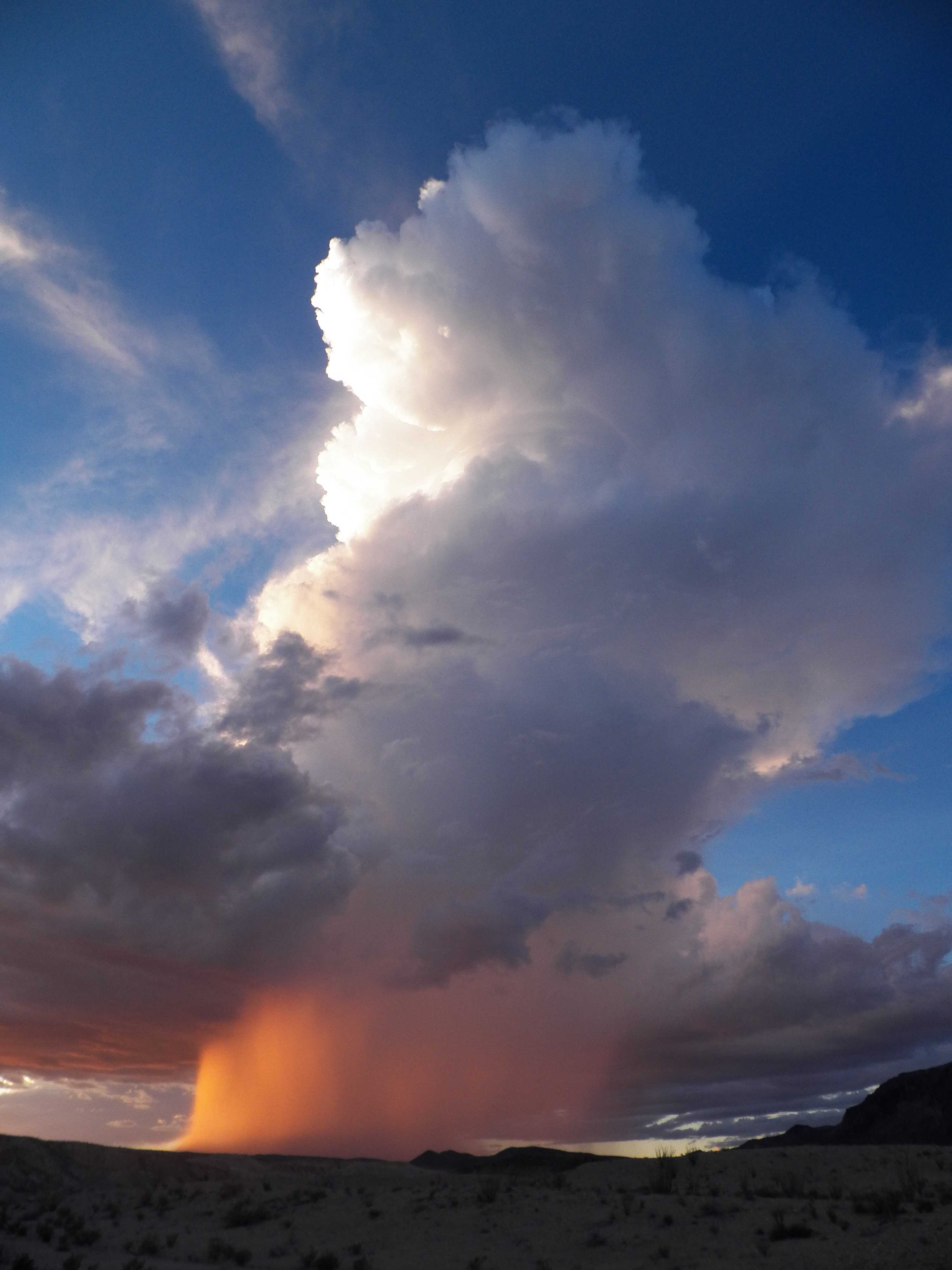
Cumulonimbus capillatus incus praecipitatio
This image shows the strong vertical extent of a rising tower of Cumulonimbus cloud. The top is lit by the evening Sun, rendering the left-hand side bright white, while the remainder of the cloud is darker. The cloud top to the right is fibrous, indicating the species capillatus, with an anvil shearing off to the right – the supplementary feature incus. The top of the cloud (as seen from this perspective) is losing sharpness as this cell transitions from Cumulus congestus to Cumulonimbus. Beneath the cloud, the Sun is lighting up a strong precipitation shaft - the supplementary feature praecipitatio. The dark grey cloud almost surrounding the powerful convective cloud is Stratocumulus, while the white fibrous cloud to the upper left is Cirrus fibratus.
Links in the image description will highlight features on the image. Mouse over the features for more detail.
© Frann BrothersTerlingua, Texas, United States of AmericaLatitude: 29° 19' 18'' NLongitude: 103° 36' 58'' W21 August 2014 1800 (Local Time)Camera direction: towards NWCL = 9, CM = 0, CH = 1Image P/S code: P.10.3Image I.D.: 4752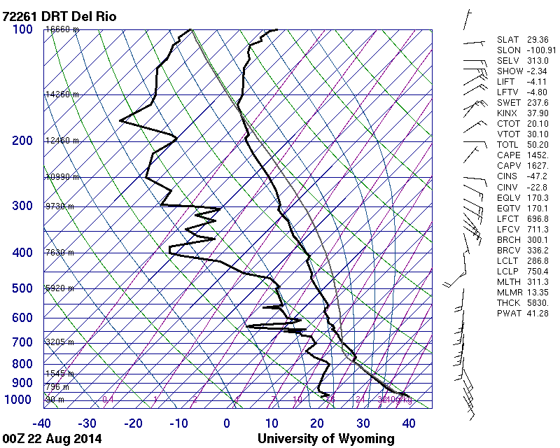 The sounding is 250 km east. The planetary boundary layer is unstable.© University of Wyoming
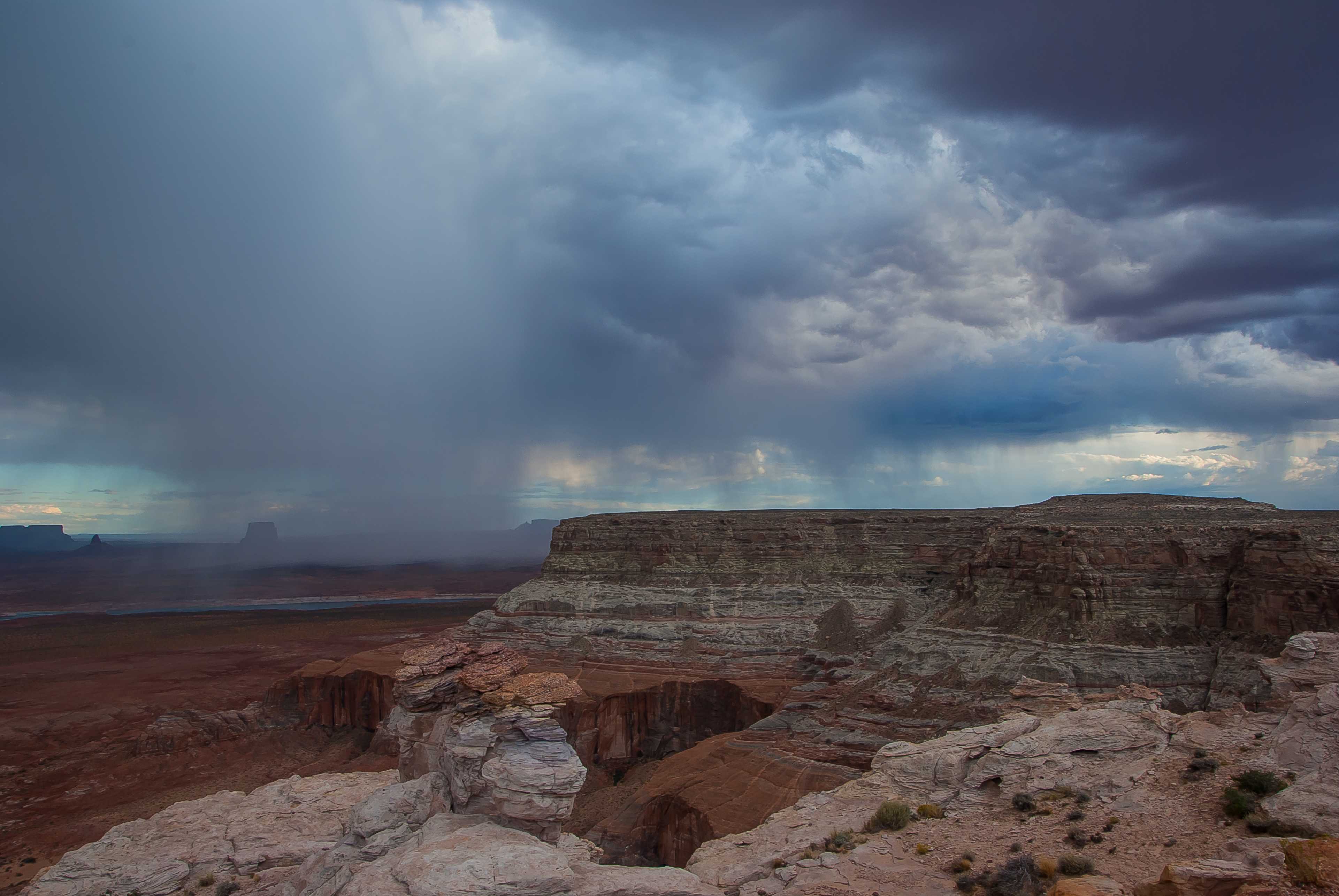
Cumulonimbus praecipitatio
The genus of these precipitating clouds is either Cumulus or Cumulonimbus. Genus is usually determined by whether the upper parts of the clouds have lost the sharpness of their outlines or have a fibrous or striated appearance.
When it is not possible to decide the genus based on the appearance of the upper parts, the cloud is by convention called Cumulonimbus if it is accompanied by lightning, thunder or hail.
In this example, the genus is Cumulonimbus as thunder was heard.
Links in the image description will highlight features on the image. Mouse over the features for more detail.
© Peter FingerKane County, UT, United States of AmericaLatitude: 37° 3' 32'' NLongitude: 111° 21' 51'' W20 September 2014 1725 (Local Time)Camera direction: towards SWCL = 3, CM = /, CH = /Image P/S code: S.10.3 30Image I.D.: 4769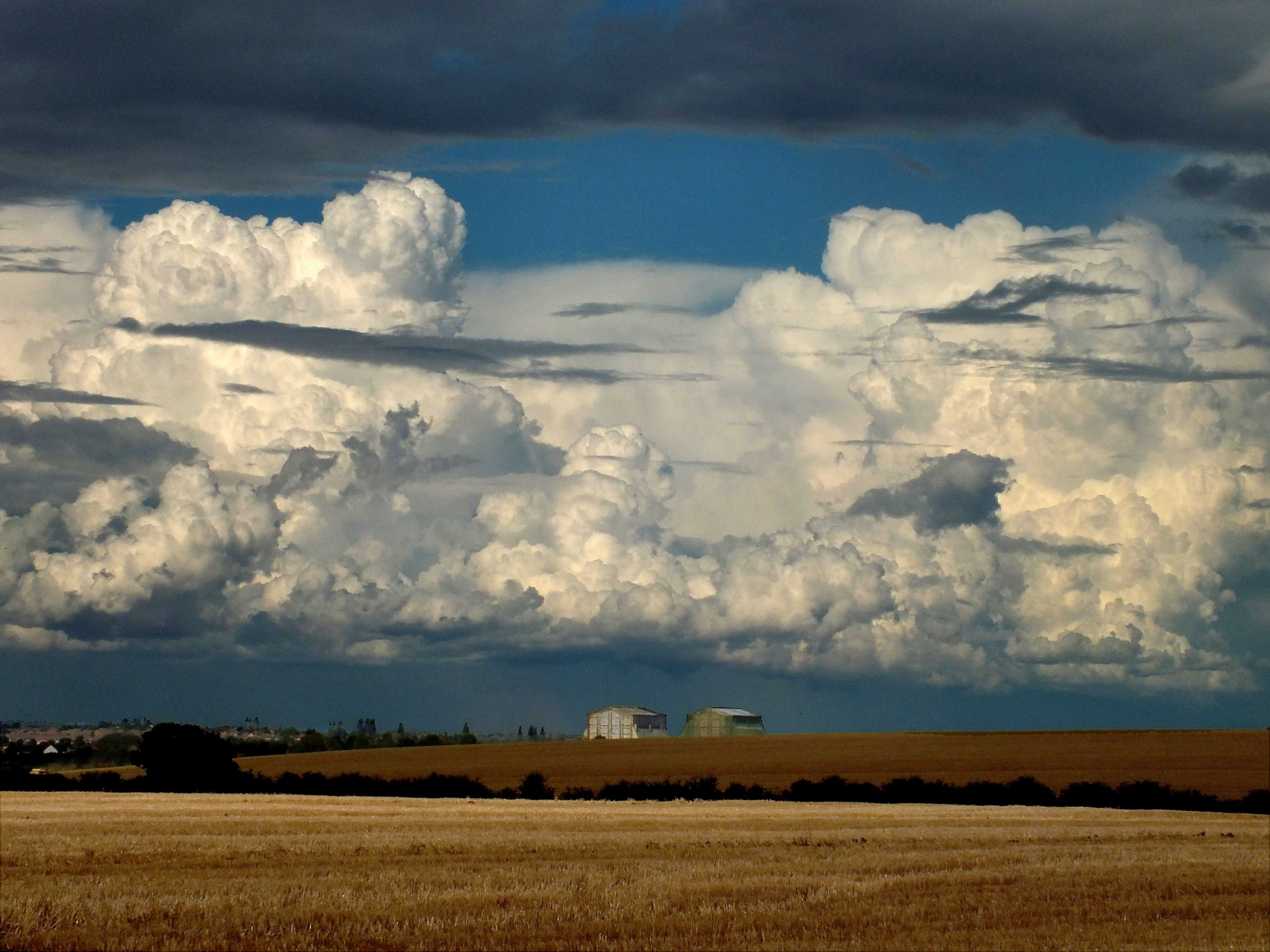
Zoomed image of line of Cumulus congestus, Cumulonimbus calvus and capillatus incus praecipitatio
A flanking line of Cumulonimbus calvus and Cumulus congestus in front of a line of mature Cumulonimbus capillatus incus cells. Distant precipitation is falling from the latter line.
Patches of Cumulus fractus and humilis are in the foreground. Many patches of Altocumulus and possibly Stratocumulus formed from the spreading of parts of Cumulonimbus complete the picture.
Links in the image description will highlight features on the image. Mouse over the features for more detail.
© Rodney HaleHoughton Conquest, Bedford, Central Bedfordshire MK45, United Kingdom of Great Britain and Northern IrelandLatitude: 52° 4' 5'' NLongitude: 0° 28' 18'' W25 August 2012 1436 (Local Time)Camera direction: towards NECL = 9, CM = 6, CH = 0Image P/S code: S.10.3 8Image I.D.: 4773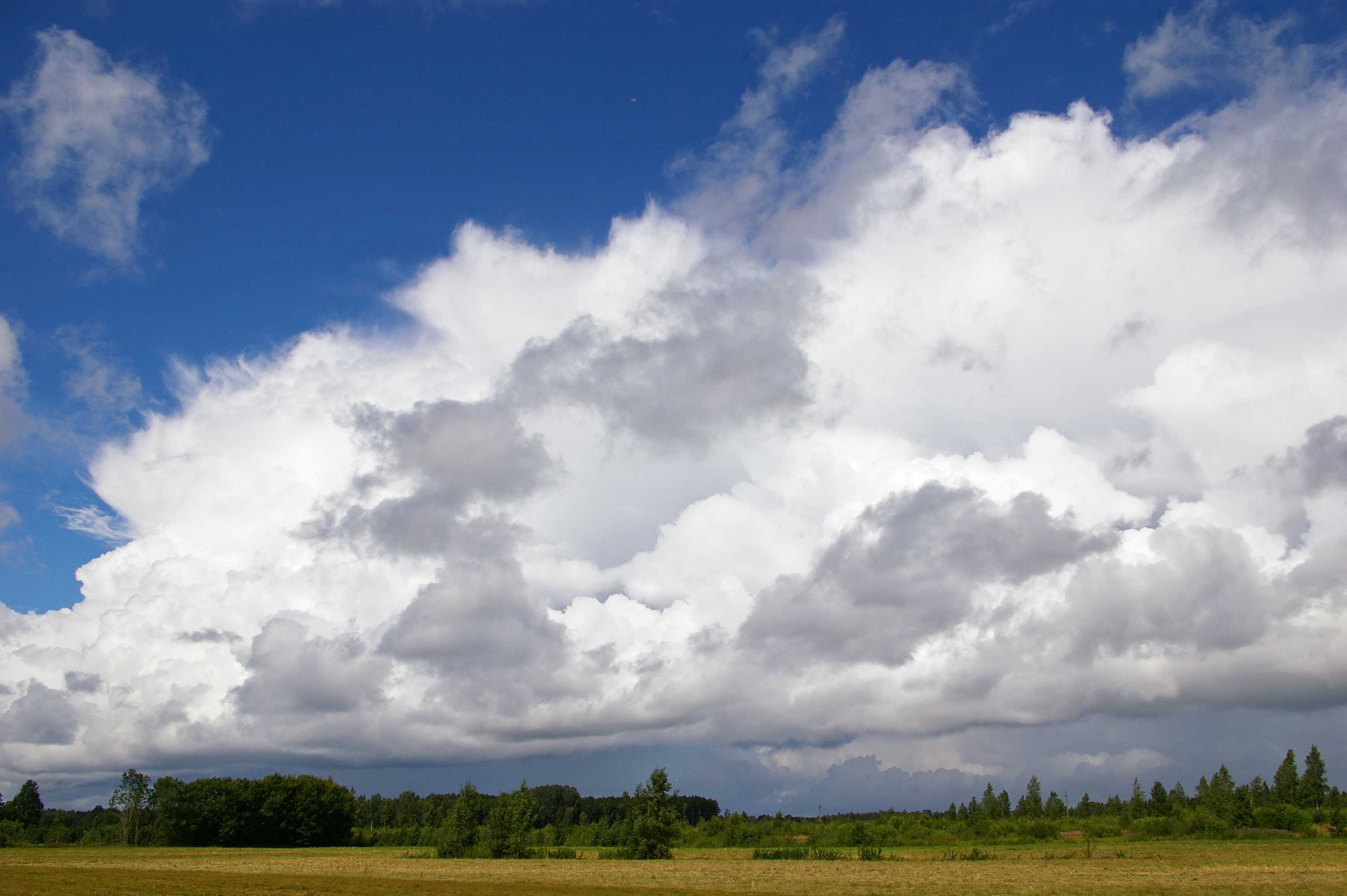
Cumulonimbus capillatus
The photograph shows developing Cumulonimbus, with an estimated cloud top height of 7 km. The upper portion of the cloud is cirriform with a fibrous structure, identifying the species as capillatus. The top is spreading out in the early stages of anvil development (at 1 and 2), which is the supplementary feature incus. Just visible in the distance is another supplementary feature: praecipitatio, which can be seen falling as showers at 3 and 4. Cumulus mediocris and Cumulus fractus are also visible in this image.
Links in the image description will highlight features on the image. Mouse over the features for more detail.
© Kairo KiitsakPapsaare, Pärnu County, EstoniaLatitude: 58° 23' 45'' NLongitude: 24° 25' 4'' E31 July 2015 1337 (Local Time)Camera direction: towards ECL = 9, CM = 0, CH = 0Image P/S code: S.10.3 3Image I.D.: 5045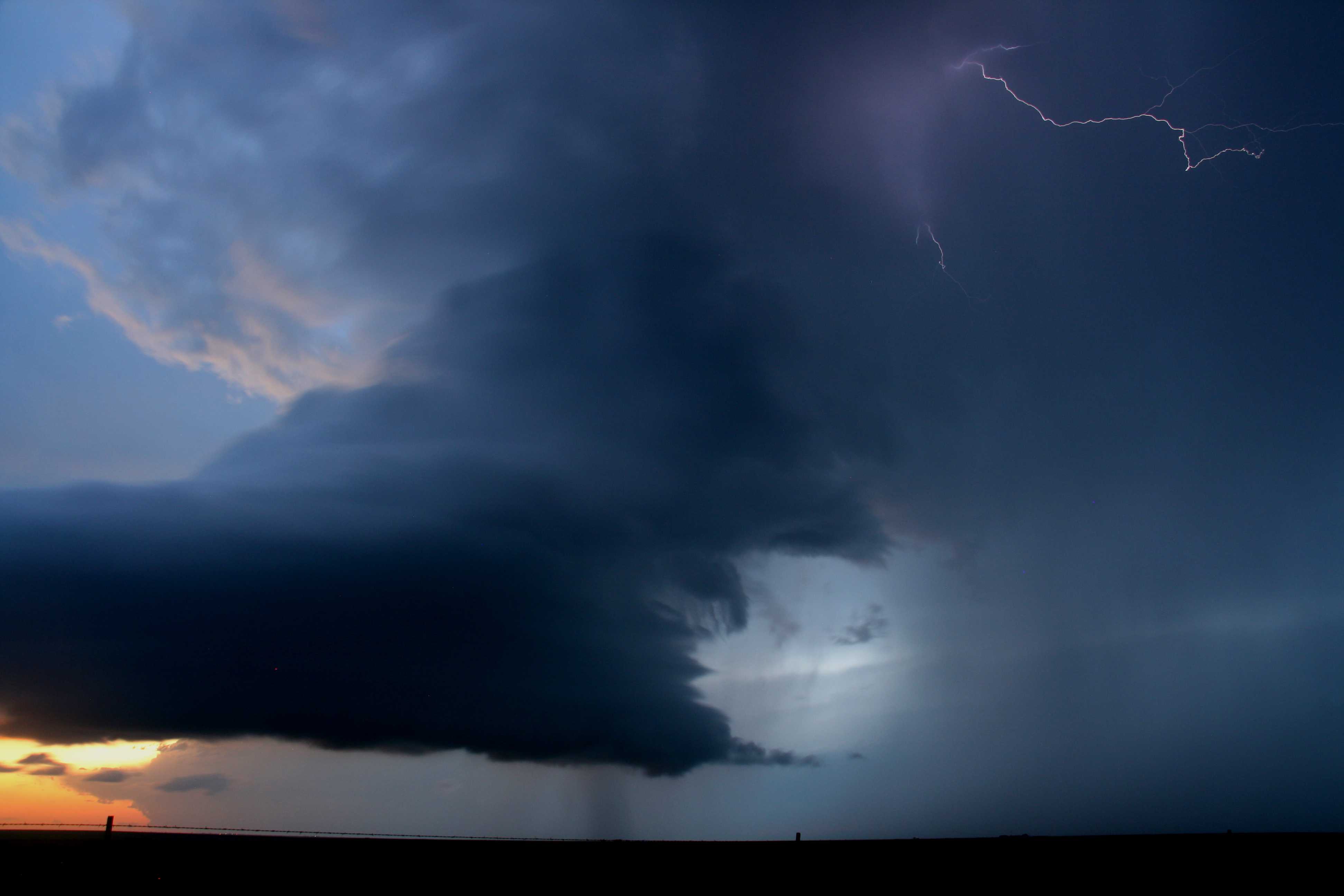
Cumulonimbus capillatus praecipitatio cauda
A low-precipitation supercell at sunset. The updraught tower was gradually narrowing as the surface temperature cooled and thermals weakened. Eventually the tower became very narrow and the updraught ceased. Precipitation (rain and hail – there were reports of golf ball-sized hail) can be seen falling out to the right (north) of the updraught tower. A small inflow tail cloud, or cauda, can be seen at the north flank of the updraught base, where rain-cooled air is being drawn into the updraught. Lightning is occurring near the updraught–downdraught interface, and part of the back-sheared anvil is lit by the low Sun. Another large Cumulonimbus can be seen in the far distance.
Links in the image description will highlight features on the image. Mouse over the features for more detail.
© Matthew ClarkHappy, Texas, United States of AmericaLatitude: 34° 38' 56'' NLongitude: 101° 55' 5'' W25 May 2010 2000 (Local Time)Camera direction: towards WNWCL = 9, CM = 0, CH = 0Image P/S code: S.10.3 5Image I.D.: 5085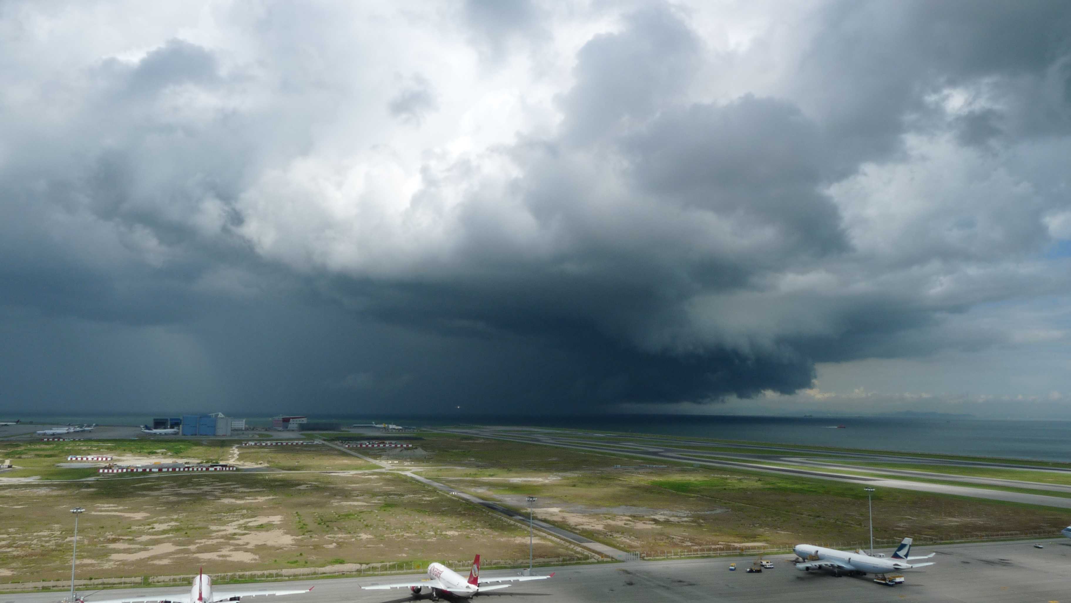
Cumulonimbus with arcus and praecipitatio
The photograph shows the lower portion of a passing Cumulonimbus cloud, in which we can see the heavy, dense nature and dark base of this genus. At the base of the cloud, to the right, we see the ragged edges of the supplementary feature arcus, which is a roll of low cloud formed by downdraughts of cold air. Also visible is an extensive shower at 2 and 3, which is the supplementary feature praecipitatio.
Links in the image description will highlight features on the image. Mouse over the features for more detail.
© Wing Choi HoChek Lap Kok, Hong Kong, ChinaLatitude: 22° 18' 54'' NLongitude: 113° 55' 21'' E02 August 2010 0913 (Local Time)Camera direction: towards WCL = 9, CM = /, CH = /Image P/S code: S.10.3 2Image I.D.: 5135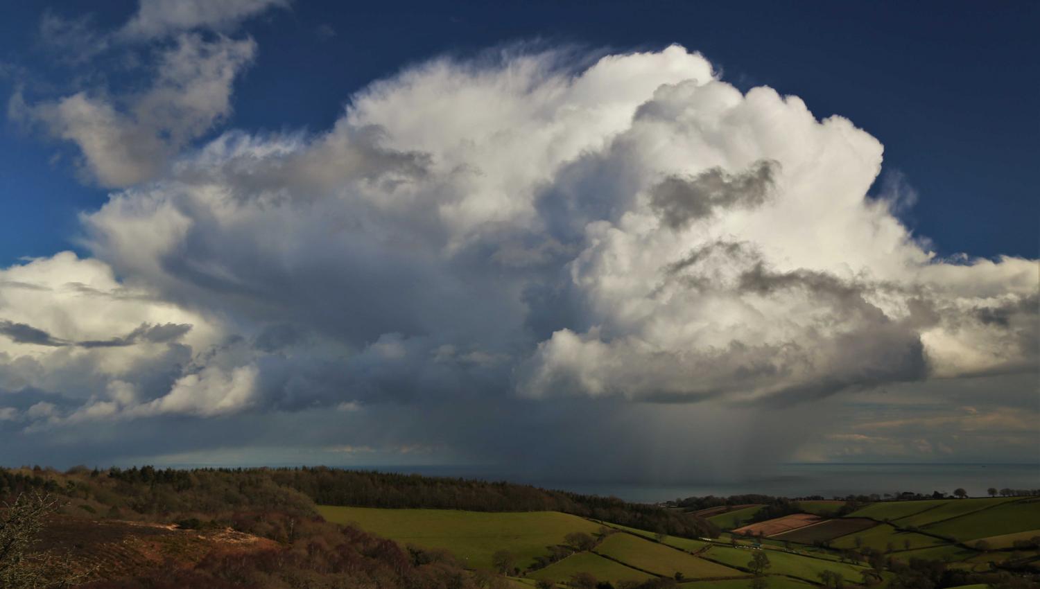
Cumulonimbus capillatus incus praecipitatio
This photograph shows one of several Cumulonimbus clouds that formed in a polar maritime air mass. They exhibited a well-organized multicellular structure, with new cells forming on the south-west flank of existing clouds. The cell on the right is losing its sharp outlines as it transitions to Cumulonimbus calvus. In the upper centre, the cloud has reached a mature phase with a cirriform top, characteristic of Cumulonimbus capillatus, while on the left, part of the anvil (incus) of a dissipating cell is visible. The cells produced showers of hail and of mixed rain and snow (supplementary feature praecipitatio). Satellite water vapour imagery suggested the showers developed ahead of a subtle, short-wave upper trough. They intensified on approaching the coast and slowly dissipated after moving offshore.
Links in the image description will highlight features on the image. Mouse over the features for more detail.
© Matthew ClarkAshcombe, near Dawlish, Devon, United Kingdom of Great Britain and Northern IrelandLatitude: 50° 34' 44'' NLongitude: 3° 31' 34'' W04 March 2016 1402 (Local Time)Camera direction: towards ECL = 9, CM = 0, CH = 0Image P/S code: S.10.3 1Image I.D.: 5514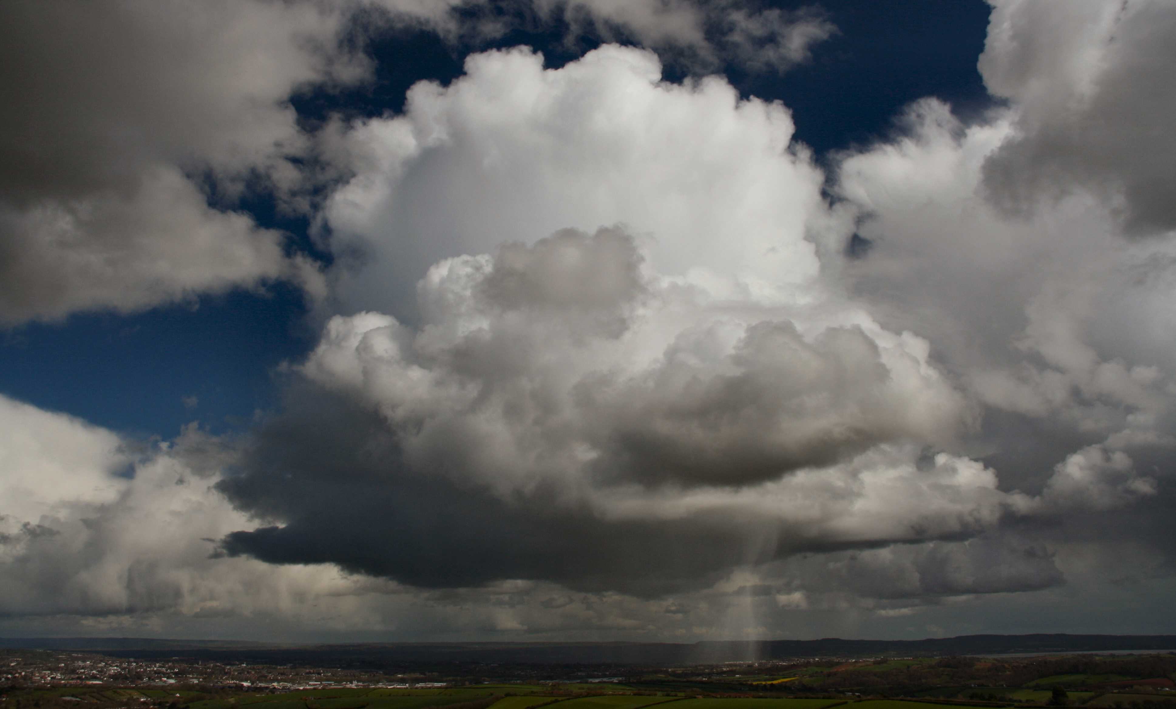
Single-cell Cumulonimbus capillatus praecipitatio over Exeter, Devon, England, UK
This Cumulonimbus has only recently transitioned from calvus to capillatus, as evidenced by the slightly fibrous texture of some of the upper parts of the cloud, which nevertheless retain a generally cumuliform structure.
A newly developed precipitation shaft, consisting of rain and possibly small hail, can be seen under the cloud base. This is especially visible where it is illuminated by the Sun on the southern flank (right-hand side) of the cloud.
The cirriform anvils of older Cumulonimbus capillatus clouds can be seen near the top right and bottom left of the photo. Virga is visible under one of these older cumulonimbus clouds, near the bottom left of the photo. Cumulus clouds of more modest vertical development are also present.
The Cumulonimbus clouds formed within an unstable polar maritime airflow on the south-western flank of a depression centred over the North Sea.
Links in the image description will highlight features on the image. Mouse over the features for more detail.
© Matthew ClarkDunchideock, Exeter, Devon EX2 9UD, United Kingdom of Great Britain and Northern IrelandLatitude: 50° 41' 28'' NLongitude: 3° 35' 28'' W10 April 2012 1310 (Local Time)Camera direction: towards ECL = 9, CM = 0, CH = 0Image P/S code: S.10.3 4Image I.D.: 5510
Extensive line of Cumulus congestus, Cumulonimbus calvus and capillatus incus praecipitatio
The image shows a flanking line of Cumulonimbus calvus and Cumulus congestus in front of a line of mature Cumulonimbus capillatus incus cells. Distant precipitation is falling from the latter line.
Ragged patches of Cumulus fractus are in the foreground, as is Stratocumulus and Altocumulus formed from the spreading of parts of Cumulonimbus.
Links in the image description will highlight features on the image. Mouse over the features for more detail.
© Rodney HaleHoughton Conquest, Bedford, Central Bedfordshire MK45, United Kingdom of Great Britain and Northern IrelandLatitude: 52° 4' 5'' NLongitude: 0° 28' 17'' W25 August 2012 1436 (Local Time)Camera direction: towards NWCL = 9, CM = 6, CH = 0Image P/S code: S.10.3 7Image I.D.: 5586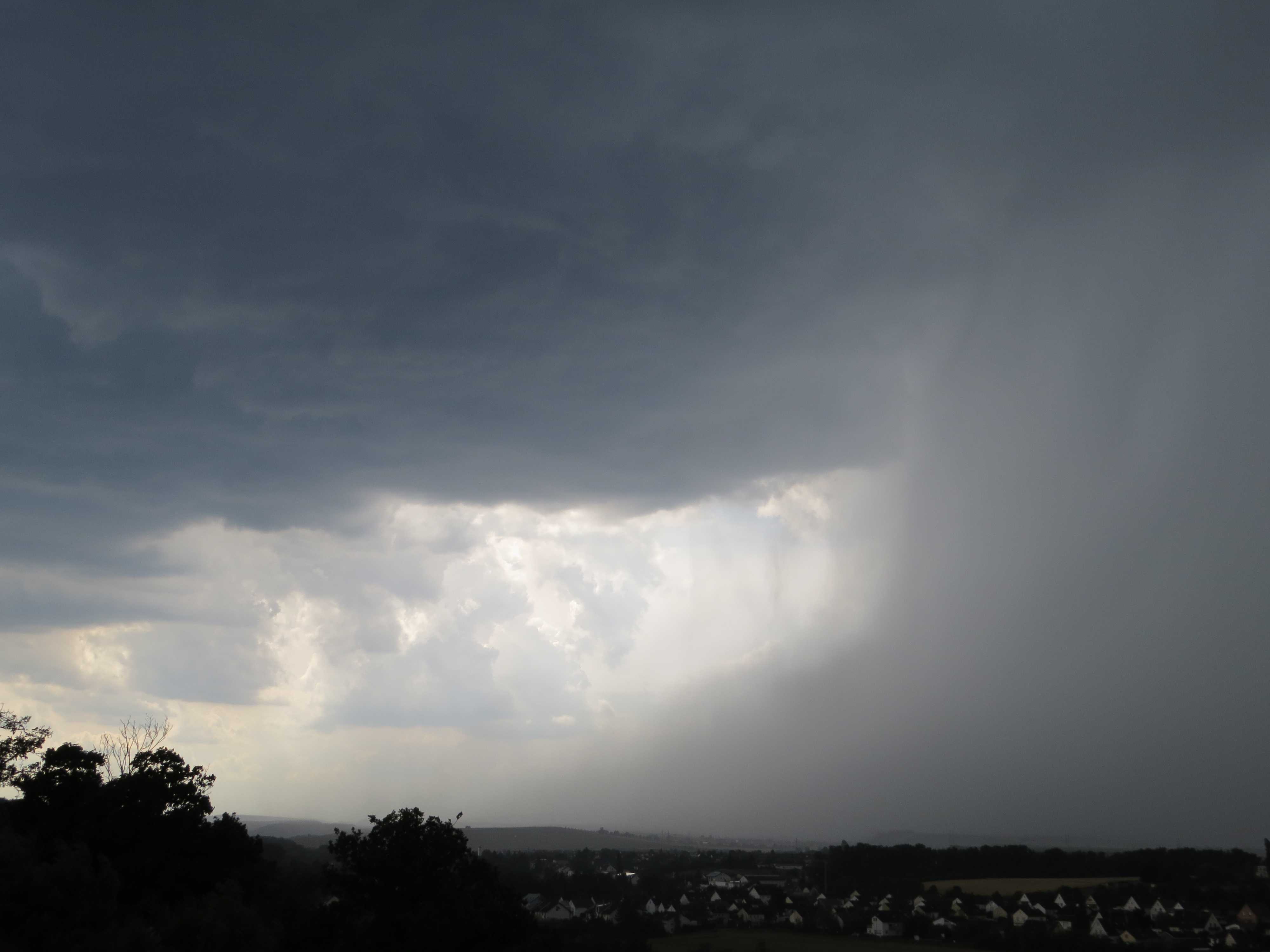
Cumulonimbus praecipitatio with a rain foot
This image shows a feature known as a rain foot at the base of a cascade of precipitation falling from a Cumulonimbus cloud.
The Cumulonimbus and its associated shower is rapidly approaching the observer's location. The picture does not show the upper portion of the Cumulonimbus and so it is not possible to decide whether the cloud belongs to the species calvus or capillatus, but by convention the coding is CL = 9. As the Cumulonimbus is precipitating, the supplementary feature 'praecipitatio' applies.
Note that the base of the rain shaft flares outwards near the ground from the main column of precipitation. This outward deflection of the precipitation near the surface is known as the rain foot and is caused by the strong outflow wind that occurs when a downdraught from the cloud reaches the ground and spreads outwards. The rain foot is therefore typically associated with a wet microburst from a thunderstorm.
Links in the image description will highlight features on the image. Mouse over the features for more detail.
© Martin GuddBad Kreuznach, GermanyLatitude: 49° 50' 39'' NLongitude: 7° 50' 32'' E06 July 2017 1548 (Local Time)Camera direction: towards WCL = 9, CM = /, CH = /Image P/S code: S.10.3Image I.D.: 6049
Cumulonimbus calvus praecipitatio
Several large cumuliform towers are situated in a group in this striking picture taken at sunset. Although these clouds are quite massive, they do not show many of the distinctive structural features of Cumulonimbus. However, the lightning at 1, 2 and 3 leaves no doubt that the cloud should be classified as Cumulonimbus. Cloud-to-ground discharges are seen at 1 and 2, and a portion of the same or a different flash is seen in the cloud at 3 and 7. Other less obvious clues are the somewhat flattened and smoothed top at 4 and the implication that the feature at 5 is part of a large cloud which is becoming diffuse and the top of which (out of the picture) is likely to be cirriform. Precipitation is falling at 6 and 7.
The clouds were located about 20 kilometres from the coast and developed as a result of the sea breeze.
Links in the image description will highlight features on the image. Mouse over the features for more detail.
© P.G. BlackMiami, FL, United States of AmericaLatitude: 25° 45' 42'' NLongitude: 80° 11' 30'' W15 July 1966 2000 (Local Time)Camera direction: towards WCL = 3, CM = 0, CH = 1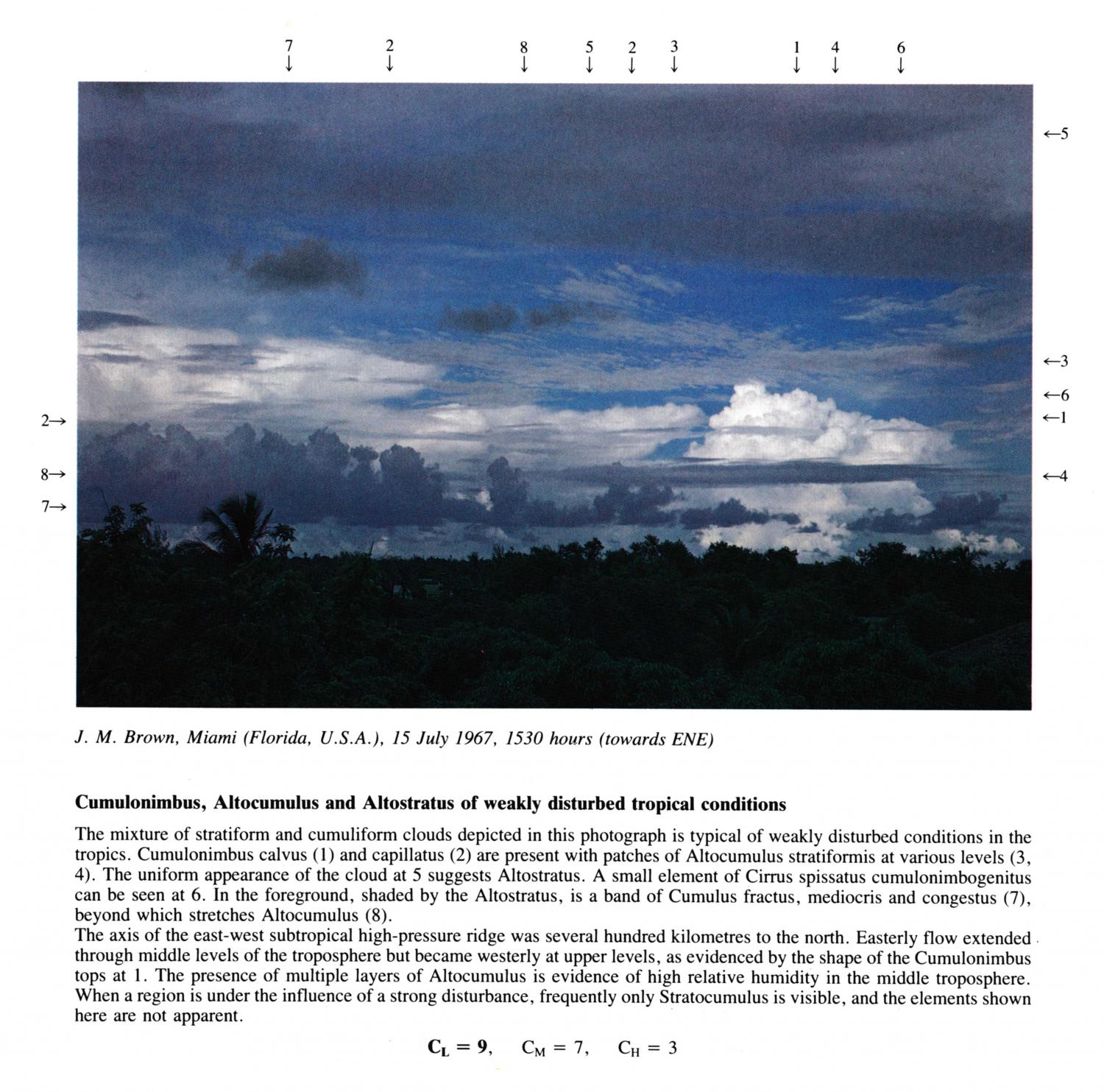
Cumulonimbus, Altocumulus and Alsostratus of weakly disturbed tropical conditions
The mixture of stratiform and cumuliform clouds depicted in this photograph is typical of weakly disturbed conditions in the tropics. Cumulonimbus calvus and capillatus are present with patches of Altocumulus stratiformis at various levels(3, 4). The uniform appearance of the cloud at 5 suggests Altostratus. A small element of Cirrus spissatus cumulonimbogenitus can be seen at 6. In the foreground, shaded by the Altostratus, is a band of Cumulus fractus, mediocris and congestus, beyond which stretches Altocumulus. The axis of the east-west subtropical high-pressure ridge was several hundred kilometres to the north. Easterly flow extended through middle levels of the troposphere but became westerly at upper levels, as evidenced by the shape of the Cumulonimbus tops at 1. The presence of multiple layers of Altocumulus is evidence of high relative humidity in the middle troposphere. When a region is under the influence of a strong disturbance, frequently only Stratocumulus is visible, and the elements shown here are not apparent.
Links in the image description will highlight features on the image. Mouse over the features for more detail.
© J.M. BrownMiami, FL, United States of AmericaLatitude: 25° 45' 42'' NLongitude: 80° 11' 30'' W15 July 1967 1530 (Local Time)Camera direction: towards ENECL = 9, CM = 7, CH = 3