© Alfons Puertas
Vallvidrera, Barcelona, Spain
Latitude: 41° 25' 6'' N
Longitude: 2° 7' 27'' E
15 September 2015 1406 (Local Time)
Camera direction: towards SE
Image P/S code: P.9.3
Image I.D.: 4766
CL = 2, CM = 0, CH = 1
-
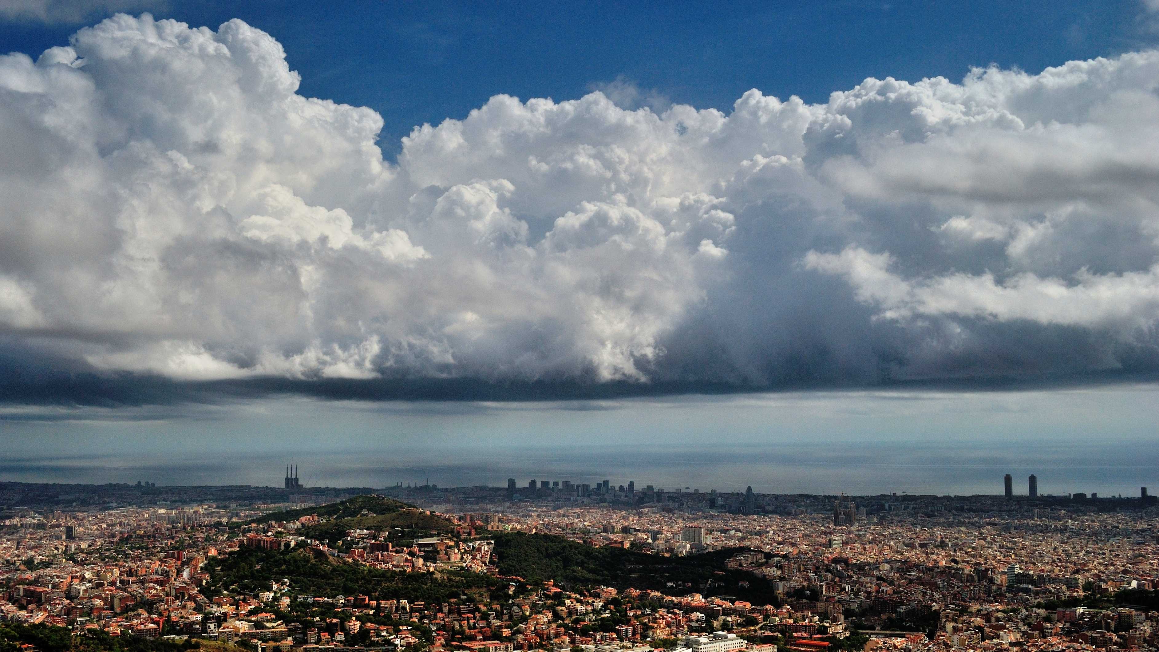
Cumulus congestus
Cumulus clouds are generally dense with sharp outlines, developing vertically in the form of rising mounds, domes or towers. Cumulus are normally detached clouds; while it is not possible to determine if these clouds are detached in this image, shadows on the sea just beyond the coast suggest a degree of separation of the main cells. They also have the characteristic very bright white sunlit parts; relatively dark and nearly horizontal base; and strong vertical extent associated with Cumulus. Significantly, the strong sprouting with sharp outlines and bulging upper parts that resemble a cauliflower at 4 and 5 determine the species to be congestus.
Links in the image description will highlight features on the image. Mouse over the features for more detail.
© Alfons PuertasVallvidrera, Barcelona, SpainLatitude: 41° 25' 6'' NLongitude: 2° 7' 27'' E15 September 2015 1406 (Local Time)Camera direction: towards SECL = 2, CM = 0, CH = 1Image P/S code: P.9.3Image I.D.: 4766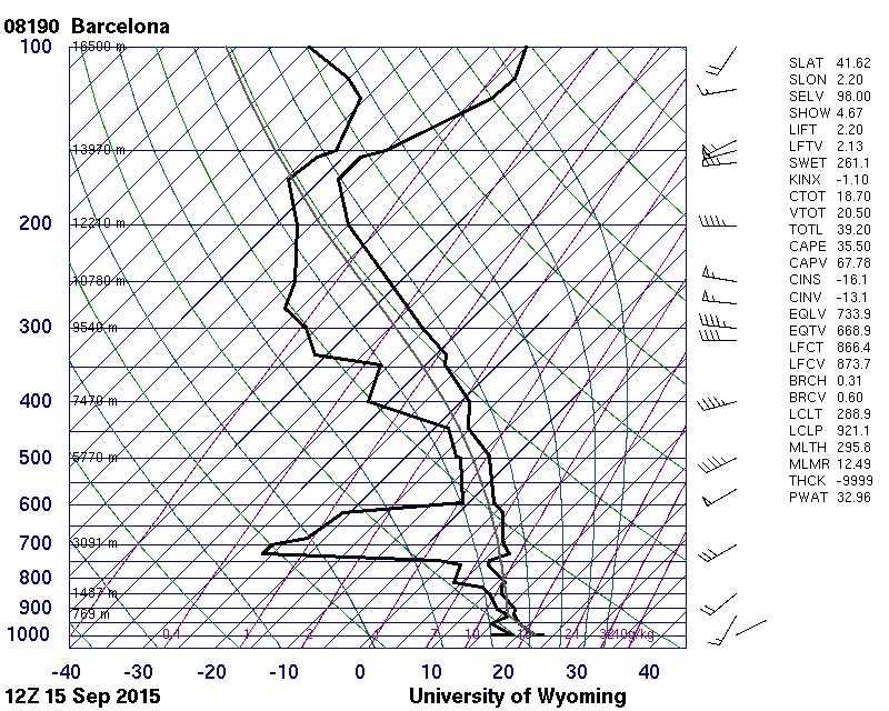
The 1200 UTC sounding from Barcelona, Spain (WMO 08190) confirms an unstable atmosphere, with considerable moisture below 850 hPa and between 600 and 450 hPa, favouring strong convective development.
© University of Wyoming
Cumulus congestus and haze
The image shows a good example of Cumulus congestus clouds with sharp outlines, dark bases and bright sunlit tops. The most developed cloud over Mt. Vesuvius, in the centre, is of great vertical extent, the upper part having strong sproutings with a cauliflower appearance. The clouds developed quickly on hillslopes in the region, in a light but unstable northerly airflow. A layer of haze can be seen on the left-hand side of the image.
Links in the image description will highlight features on the image. Mouse over the features for more detail.
© Stephen BurtSorrento, Naples, ItalyLatitude: 40° 37' 52'' NLongitude: 14° 22' 60'' E26 May 2015 0926 (Local Time)Camera direction: towards NCL = 2, CM = 0, CH = 0Image P/S code: S.9.3 10Image I.D.: 3876
Cumulus congestus
The photograph shows a strongly sprouting Cumulus cloud of moderate vertical extent. It has sharp outlines, a dark horizontal base and bright white sunlit tops. The bulging upper part resembles a cauliflower. On the left of the image, the cloud appears to be flattening out, leading to the development of Stratocumulus cumulogenitus.
Links in the image description will highlight features on the image. Mouse over the features for more detail.
© Raimundas StonkusNida, LithuaniaLatitude: 55° 18' 35'' NLongitude: 21° 0' 36'' E26 August 2014 1713 (Local Time)Camera direction: towards NECL = 2, CM = 0, CH = 0Image P/S code: S.9.3 26Image I.D.: 4738
Cumulus congestus and other species
There are several species of Cumulus in this picture, but the clouds are mainly of moderate to large vertical extent – the species mediocris and congestus respectively. The congestus at 1, 2, 3 and 4 is shown by the towers of strongly sprouting Cumulus, the bulging upper parts of which resemble a cauliflower. In some instances the clouds resemble narrow, very high towers.
Links in the image description will highlight features on the image. Mouse over the features for more detail.
© Marcin KocybikDubai - United Arab EmiratesLatitude: 25° 3' 57'' NLongitude: 55° 31' 0'' E29 November 2015 1200 (Local Time)Camera direction: towards WCL = 2, CM = 0, CH = 0Image P/S code: S.9.3 9Image I.D.: 4751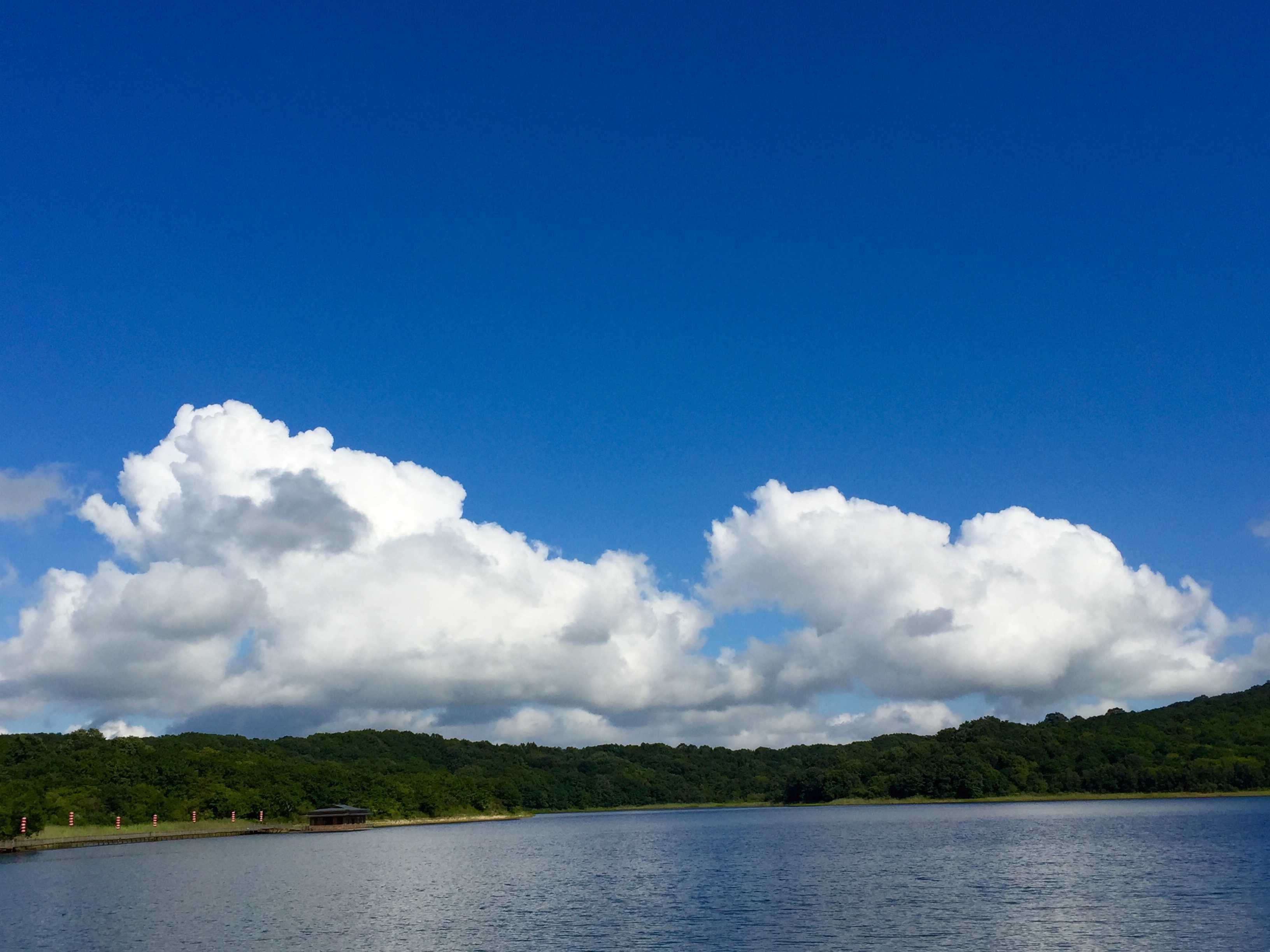
Cumulus congestus
This image shows some of the general features of Cumulus clouds. They are detached, generally dense with sharp outlines and develop vertically in the form of rising mounds, domes or towers. The sunlit parts are brilliant white, with a darker, nearly horizontal base. In this instance, there is a noticeable shear from right to left on the upper part of the clouds. The cell on the left is of considerable vertical extent and is beginning to sprout strongly, with the bulging upper part resembling a cauliflower; this identifies the Cumulus as the species congestus. The small grey cloud on the left is much closer to the camera and has the rather ragged appearance of Cumulus fractus.
Links in the image description will highlight features on the image. Mouse over the features for more detail.
© Da Wei XuHunchun, Yanbian, Jilin, ChinaLatitude: 42° 51' 16'' NLongitude: 130° 23' 15'' E28 August 2015 1357 (Local Time)CL = 2, CM = 0, CH = 0Image P/S code: S.9.3 30Image I.D.: 4772
Stratocumulus cumulogenitus homogenitus
A Cumulus congestus homogenitus cloud has formed here above the Mělník power station in the Czech Republic. The name “homogenitus” denotes that the cloud formed as a direct result of human activity; in this case, as a result of the rising thermals from the power station chimneys condensing in the cold surrounding air.
Although the Cumulus top extends to a considerable height, some cloud has spread out under a temperature inversion at a height of about 2 000 m to form a layer of Stratocumulus. As the Stratocumulus was formed by the spreading of Cumulus, the mother-cloud name cumulogenitus applies. In addition, because this cloud also resulted from human activity, the name homogenitus applies here too. This cloud is therefore Stratocumulus cumulogenitus homogenitus. In the background, there is some natural Cumulus mediocris and Cumulus congestus.
Links in the image description will highlight features on the image. Mouse over the features for more detail.
© Karlona PlskovaSmolnice, Czech RepublicLatitude: 50° 19' 34'' NLongitude: 13° 51' 57'' E18 January 2016 1440 (Local Time)Camera direction: towards SECL = 4, CM = 0, CH = 0Image P/S code: S.7.23Image I.D.: 4893
Cumulus congestus and Cirrostratus with parhelion and partial 22° halo
Seen here are Cumulus congestus, narrow tower shearing, and patches of Altocumulus and Cirrostratus, with a partial 22° halo and a parhelion coming from the latter. A few Cirrus elements and a layer of haze (close to the ground) are illuminated by the low Sun.
Links in the image description will highlight features on the image. Mouse over the features for more detail.
© Irene HoPak Nai, Lau Fau Shan, Hong Kong, ChinaLatitude: 22° 26' 6'' NLongitude: 113° 56' 54'' E15 July 2010 1828 (Local Time)Camera direction: towards WSWCL = 2, CM = 3, CH = 8Image P/S code: S.9.3 28Image I.D.: 5035
Cumulus congestus
In this photograph we see the strong vertical development of a Cumulus congestus cloud in the form of a narrow high tower, also called a “towering Cumulus”, with the sharp outlines characteristic of the genus Cumulus. The early morning Sun is catching the top of the cloud, rendering it very bright compared to the dark base. To the right near the horizon are a series of Cumulus clouds in various stages of development. Also visible is a layer of thin Cirrus cloud, coloured pink just after sunrise.
Links in the image description will highlight features on the image. Mouse over the features for more detail.
© Irene Ho Pik HarClear Water Bay, Hong Kong, ChinaLatitude: 22° 16' 44'' NLongitude: 114° 17' 7'' E01 August 2010 0547 (Local Time)Camera direction: towards ECL = 2, CM = 0, CH = 1Image P/S code: S.9.3 5Image I.D.: 5039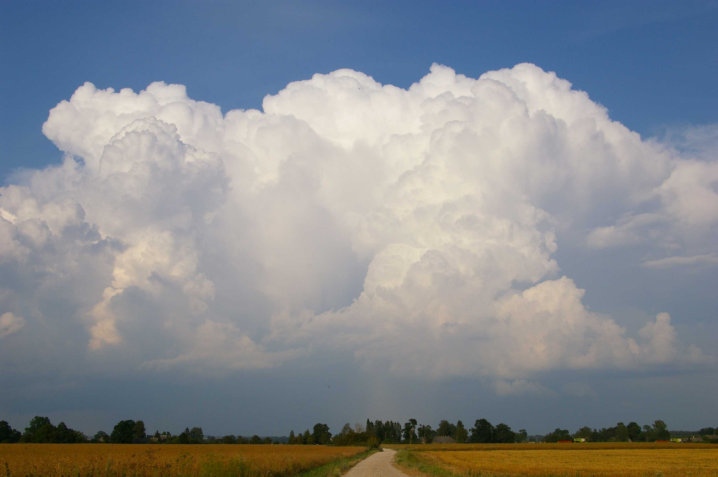
Cumulus congestus
The photograph shows strongly sprouting Cumulus cloud of moderate vertical extent. It has sharp outlines with bright white cloud tops and a dark horizontal base, which are characteristic of the species congestus. The bulging upper part resembles a cauliflower. The cloud in this image was in a growing phase and produced a thunderstorm soon after. The rain shower falling from the base of the cloud is the supplementary feature praecipitatio.
Links in the image description will highlight features on the image. Mouse over the features for more detail.
© Kairo KiitsakSimuna, EstoniaLatitude: 59° 2' 43'' NLongitude: 26° 24' 3'' E15 July 2014 1859 (Local Time)Camera direction: towards NECL = 2, CM = 0, CH = 0Image P/S code: S.9.3 4Image I.D.: 5044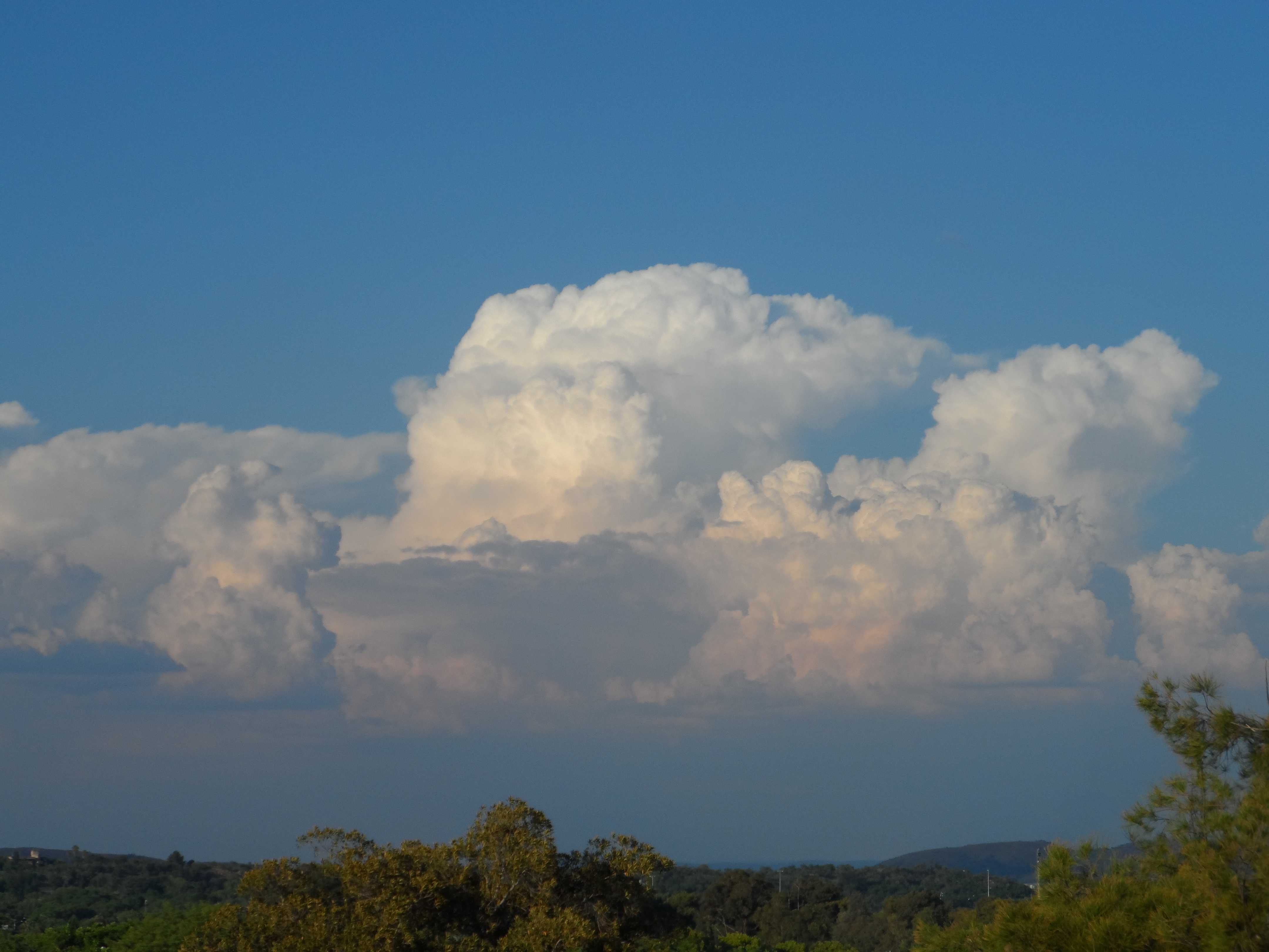
Cumulus congestus and Altocumulus cumulogenitus
The image shows strongly sprouting Cumulus with sharp outlines and of reasonable vertical extent. The sunlit parts are bright white, while their base is relatively dark and nearly horizontal. The bulging upper part resembles a cauliflower, which is characteristic of the species congestus, and has not yet become indistinct. Behind the developing cell on the left of the photograph, the cloud has spread out to form Altocumulus cumulogenitus as the Cumulus has reached a stable layer in the process of vertical development.
Links in the image description will highlight features on the image. Mouse over the features for more detail.
© Nikki MiguelPretoria, South AfricaLatitude: 25° 45' 17'' SLongitude: 28° 14' 22'' E13 January 2016 1754 (Local Time)Camera direction: towards NECL = 2, CM = 6, CH = 0Image P/S code: S.9.3 7Image I.D.: 5049
Cumulus congestus
This image shows the generally dense nature of a Cumulus cloud developing vertically. In this example we can see narrow high towers (at 1 and 2), which define them as the species congestus. Also note the dark and nearly horizontal cloud bases. The sharp outlines and bright white sunlit upper parts, typical of Cumulus, can just be seen near the centre of the image, but from this perspective the cauliflower appearance of the upper parts of congestus cannot be seen.
Links in the image description will highlight features on the image. Mouse over the features for more detail.
© Stefan KämpfeWeimar, GermanyLatitude: 50° 58' 53'' NLongitude: 11° 18' 13'' E24 June 2011 1000 (Local Time)Camera direction: towards NWCL = 2, CM = 0, CH = 0Image P/S code: S.9.3 27Image I.D.: 5124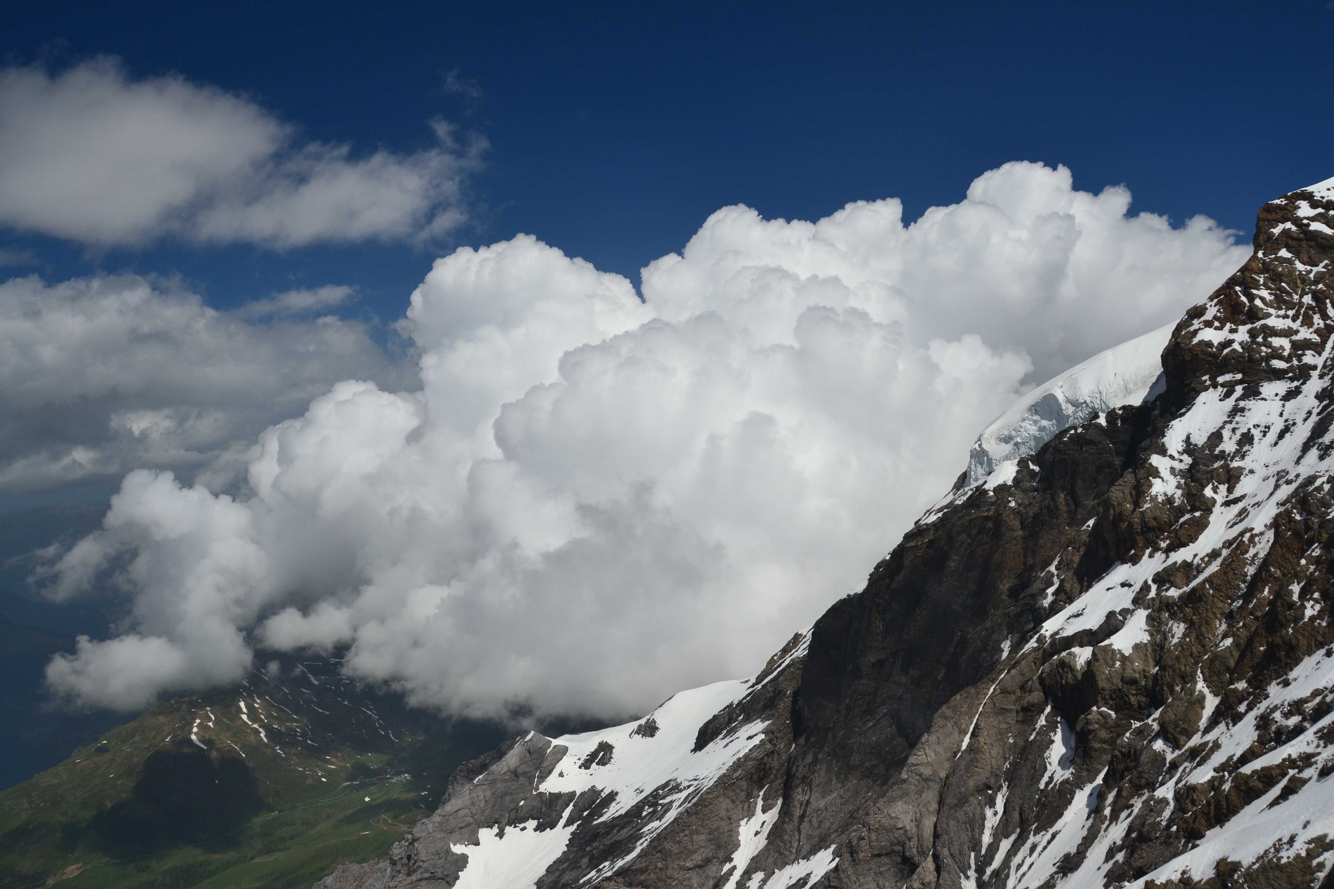
Cumulus congestus
The photograph shows strongly sprouting Cumulus congestus of moderate to great vertical extent. The cloud has sharp outlines with bright white sunlit tops and is seen developing over the Eiger, Bernese Alps, Switzerland from Jungfraujoch, Bernese Alps, Switzerland (3 454 m). The bulging upper parts of the Cumulus resemble a cauliflower. Patches of Cumulus fractus can be seen at the top left of the image.
Links in the image description will highlight features on the image. Mouse over the features for more detail.
© Javier Ceberio GarcíaJungfraujoch, SwitzerlandLatitude: 46° 32' 16'' NLongitude: 7° 57' 38'' E21 June 2012 1226 (Local Time)Camera direction: towards ECL = 2, CM = 0, CH = 0Image P/S code: S.9.3 3Image I.D.: 5125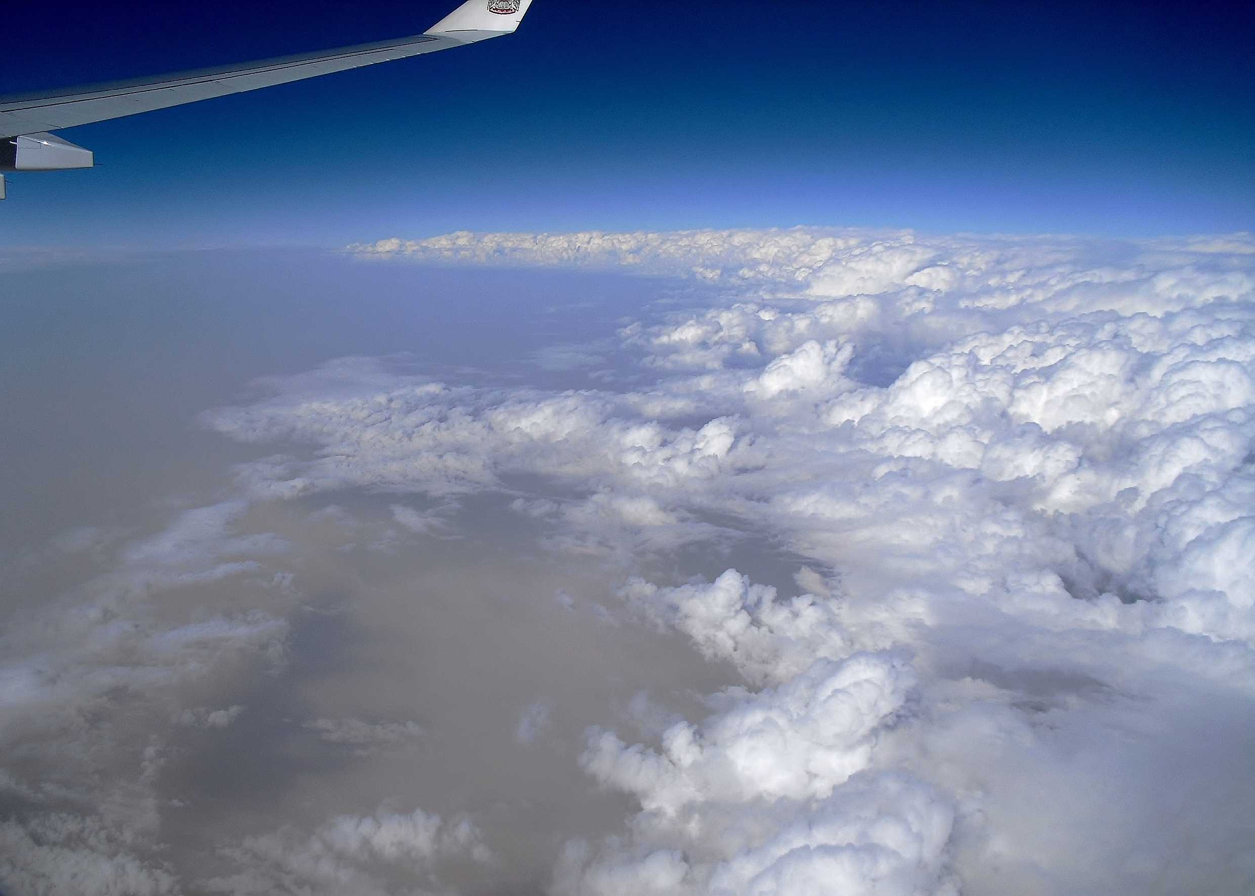
Cumulus congestus and dust
The image shows an area of convection from about 10 400 m (34 000 ft) over southern Iraq. The cloud is mainly Cumulus congestus, indicated by sharp outlines and a lumpy cauliflower appearance. Small amounts of Cumulonimbus (upper centre) and Altocumulus (centre left) can be seen. To the left, the sky is cloudless and ground shadows (lower left) are diffuse due to thick dust haze in the lower atmosphere, resulting from strong surface winds. Nasiriya, Iraq (WMO 40676) reported 200 m visibility in a dust storm and sharply falling pressure at 1500 hours and 5 km in dust haze at 1800 hours.
Links in the image description will highlight features on the image. Mouse over the features for more detail.
© Frank Le BlancqSouthern IraqLatitude: 31° 24' 36'' NLongitude: 47° 19' 24'' E20 February 2011 1526 (Local Time)Camera direction: towards ENECL = 2, CM = 0, CH = 0Image P/S code: S.9.3 2Image I.D.: 5127
Cumulus congestus and dust
The image shows the clearance of an area of convection seen from 10 400 m (34 000 ft) over southern Iraq. The cloud is mainly Cumulus congestus, identified by sharp outlines and a lumpy cauliflower appearance. Some Cumulonimbus can also be seen at 2 and 3, while Altocumulus (centre right) is trailing behind the main cloud clearance. Behind the front the sky is cloudless, but there is widespread thick dust haze in the lower atmosphere. Nasiriya, Iraq (WMO 40676) reported 200 m visibility in a dust storm at 1500 hours and 5 km in dust haze at 1800 hours.
Links in the image description will highlight features on the image. Mouse over the features for more detail.
© Frank Le BlancqSouthern IraqLatitude: 31° 43' 30'' NLongitude: 47° 10' 19'' E20 February 2011 1529 (Local Time)Camera direction: towards ESECL = 2, CM = 0, CH = 0Image P/S code: S.9.3 1Image I.D.: 5128
Cumulus congestus, humilis and fractus
This is an example of a developing Cumulus congestus with “bulging upper parts” in the two updraughts at 1 and 2. While the “bulging upper parts resemble a cauliflower”, it is noted that the Cumulus is not of great vertical extent. A decaying Cumulus congestus is to the left of the main cell. Cumulus fractus and humilis are also present.
Links in the image description will highlight features on the image. Mouse over the features for more detail.
© Wai Yan LukTsing Ma Bridge, Hong Kong, ChinaLatitude: 22° 21' 4'' NLongitude: 114° 4' 24'' E08 November 2015 1703 (Local Time)Camera direction: towards NWCL = 2, CM = 0, CH = 0Image P/S code: S.9.3 8Image I.D.: 5603
Cumulus congestus
Cumulus congestus are strongly sprouting Cumulus clouds with generally sharp outlines and are of moderate to strong vertical extent; sometimes congestus resemble narrow, very high towers. The bulging upper part frequently resembles a cauliflower. Cumulus congestus usually develops from Cumulus mediocris (3 and 4) and may produce precipitation in the form of showers, though none can be seen in this image. Visible in the background of this photograph are Cirrostratus and, near the top, an aircraft condensation trail.
Links in the image description will highlight features on the image. Mouse over the features for more detail.
© Chi Yung LauChek Lap Kok, Hong Kong, ChinaLatitude: 22° 18' 55'' NLongitude: 113° 55' 22'' E19 July 2010 1156 (Local Time)Camera direction: towards NWCL = 2, CM = 0, CH = 8Image P/S code: S.9.3 10Image I.D.: 5901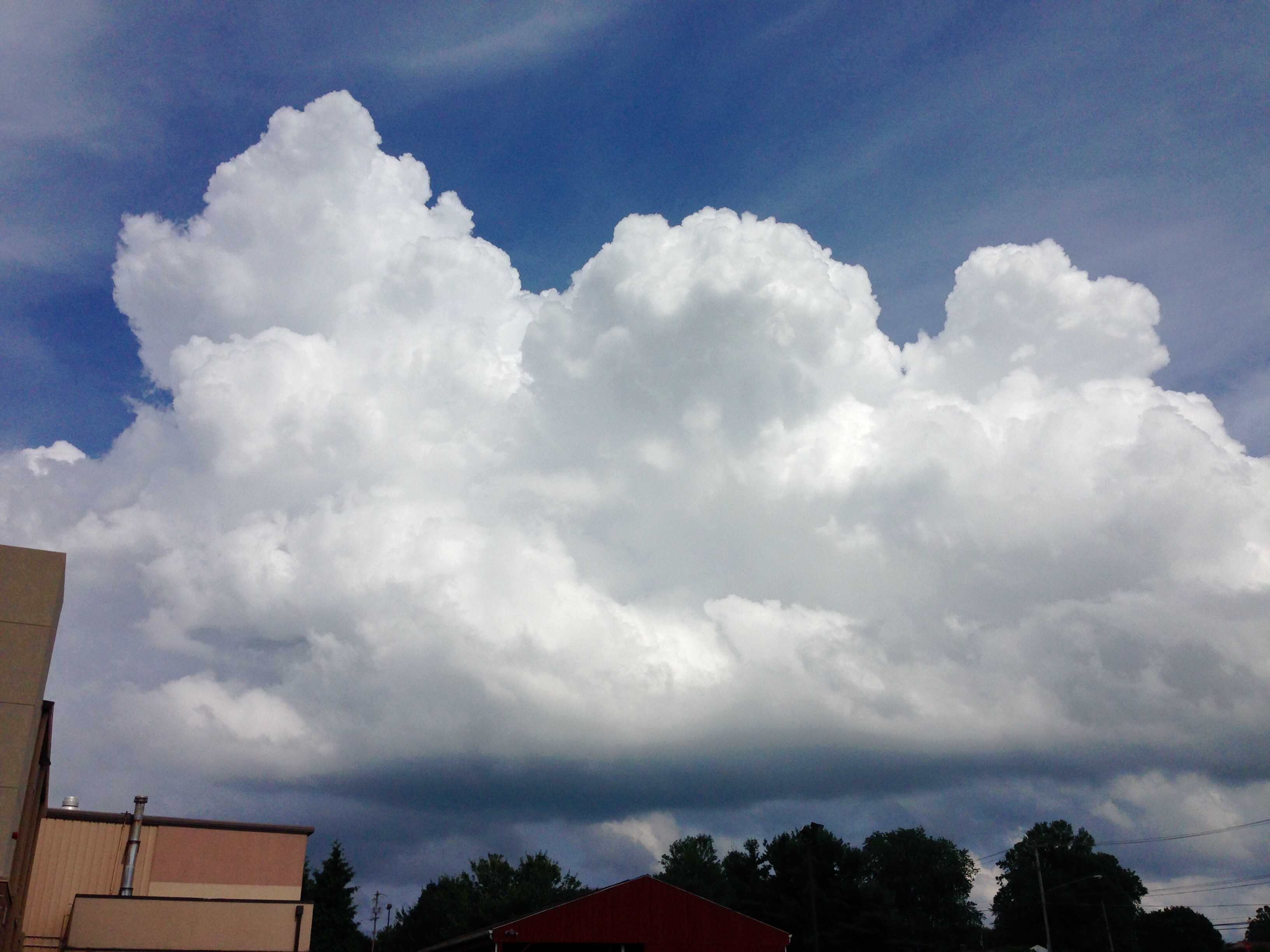
Cumulus congestus
Cumulus are detached clouds, generally dense and with sharp outlines. They develop vertically in the form of rising mounds, domes or towers. The sunlit parts are mostly brilliant white, with a relatively dark and nearly horizontal base. Cumulus congestus, as seen in this image, are strongly sprouting Cumulus clouds of moderate to strong vertical extent (at least 2 to 3 km) with the bulging upper part resembling a cauliflower. These clouds may produce precipitation in the form of showers, and in this instance a thunderstorm was reported in the vicinity shortly after the image was taken. Congestus usually develops from the species mediocris. Cirrus can be seen near the top of the image.
Links in the image description will highlight features on the image. Mouse over the features for more detail.
© Dominic HernandezWest Grove, Pennsylvania, United States of AmericaLatitude: 39° 49' 20'' NLongitude: 75° 49' 39'' W06 July 2015 1558 (Local Time)Camera direction: towards ECL = 2, CM = 0, CH = 1Image P/S code: S.9.3 9Image I.D.: 5912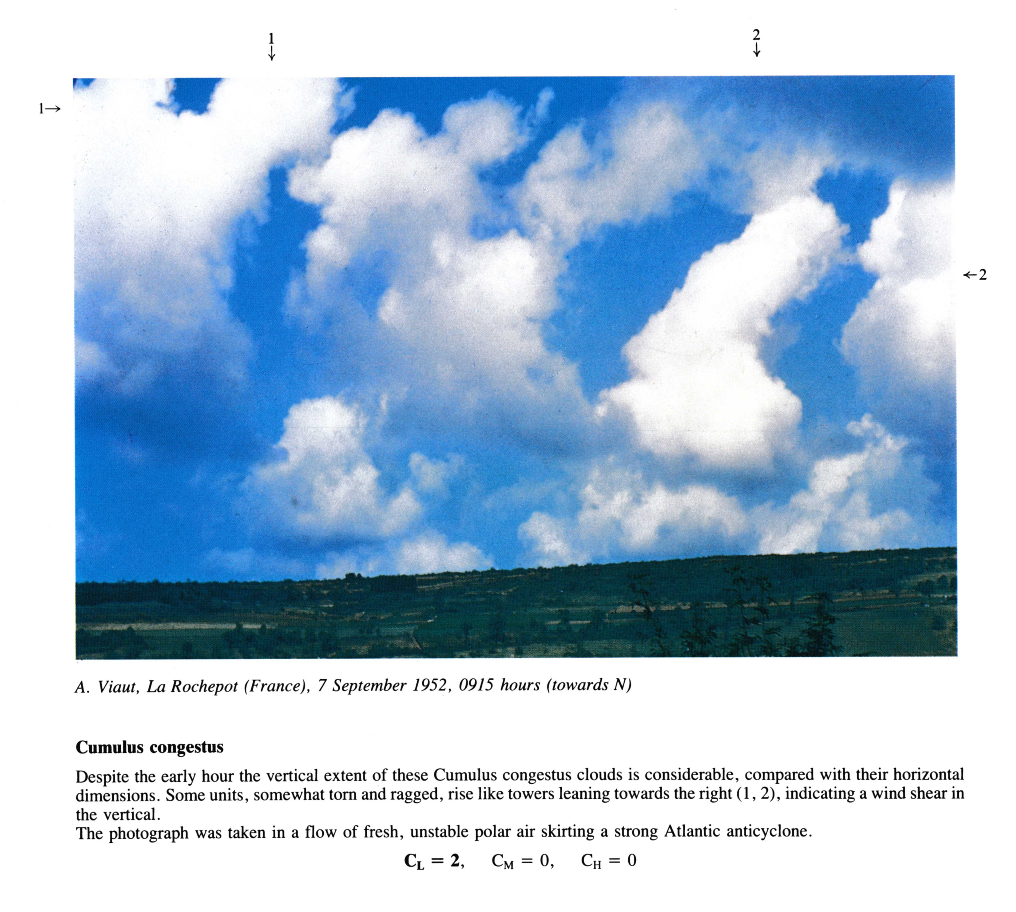
Cumulus congestus
Despite the early hour the vertical extent of these Cumulus congestus clouds is considerable, compared with their horizontal dimensions. Some units, somewhat torn and ragged, rise like towers leaning towards the right at 1 and 2, indicating a wind shear in the vertical.
The photograph was taken in a flow of fresh, unstable polar air skirting a strong Atlantic anticyclone.
CL = 2, CM = 0, CH = 0
Links in the image description will highlight features on the image. Mouse over the features for more detail.
© A. Viaut21340 La Rochepot, FranceLatitude: 46° 57' 28'' NLongitude: 4° 40' 43'' E07 September 1952 0915 (Local Time)Camera direction: towards N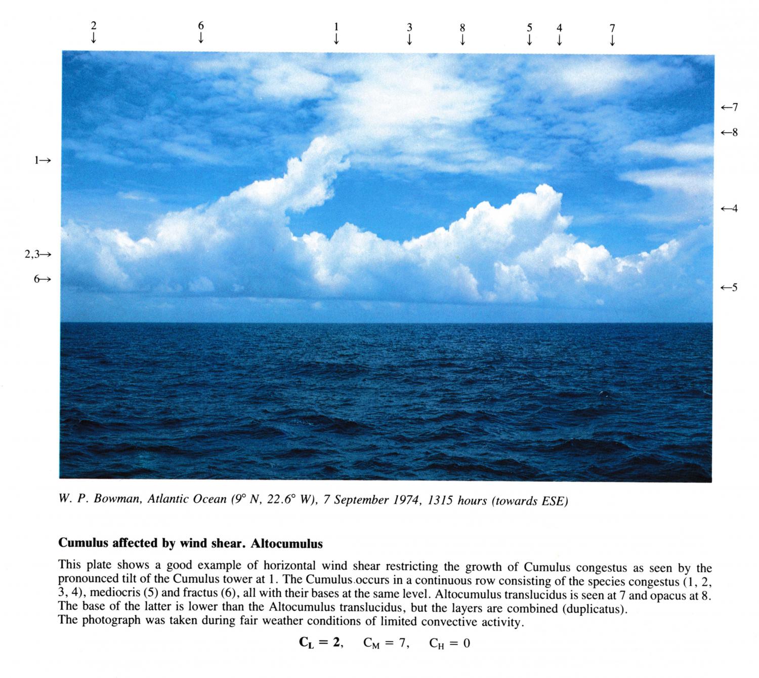
Cumulus affected by wind shear. Altocumulus
This plate shows a good example of horizontal wind shear restricting the growth of Cumulus congestus as seen by the pronounced tilt of the Cumulus tower at 1. The Cumulus.occurs in a continuous row consisting of the species congestus at 1, 2, 3 and 4, mediocris and fractus, all with their bases at the same level. Altocumulus translucidus is seen at and opacus at.
The base of the latter is lower than the Altocumulus translucidus, but the layers are combined (duplicatus).
The photograph was taken during fair weather conditions of limited convective activity.
Links in the image description will highlight features on the image. Mouse over the features for more detail.
© W.P. BowmanAtlantic OceanLatitude: 9° 0' 0'' NLongitude: 22° 36' 0'' W07 September 1974 1315 (Local Time)Camera direction: towards SECL = 2, CM = 7, CH = 0
Cumulus congestus in a row
The Cumulus towers at 1, 2 and 3 all rise from a uniform cloud base. The cloud column at 1 shows some evidence of evaporation, but there are no cirriform features which would identify it as Cumulonimbus. The tallest tower extends to a height of about 6000 metres. These clouds are growing vertically over a tropical land mass and no precipitation is evident from the clear-cut, horizontal base. A Cumulonimbus calvus developed from these clouds soon after the photograph had been taken. Some of the cloud tops are inclined towards the right of the picture because of a vertical wind shear. Some patches of
Altocumulus can be seen to the left of the tallest Cumulus tower.
The clouds were aligned SSW-NNE along a sea-breeze convergence line which had moved inland during the afternoon.
Links in the image description will highlight features on the image. Mouse over the features for more detail.
© J.H. GoldenMiami, FL, United States of AmericaLatitude: 25° 45' 42'' NLongitude: 80° 11' 30'' W15 September 1966 1930 (Local Time)Camera direction: towards WCL = 2, CM = 3, CH = 1