© Sylke Boyd
Hodges Township, Minnesota, United States of America
Latitude: 45° 33' 37'' N
Longitude: 95° 50' 1'' W
09 September 2015 1814 (Local Time)
Camera direction: towards NE
Image P/S code: P.10.12
Image I.D.: 4770
CL = 3, CM = 0, CH = 0
-
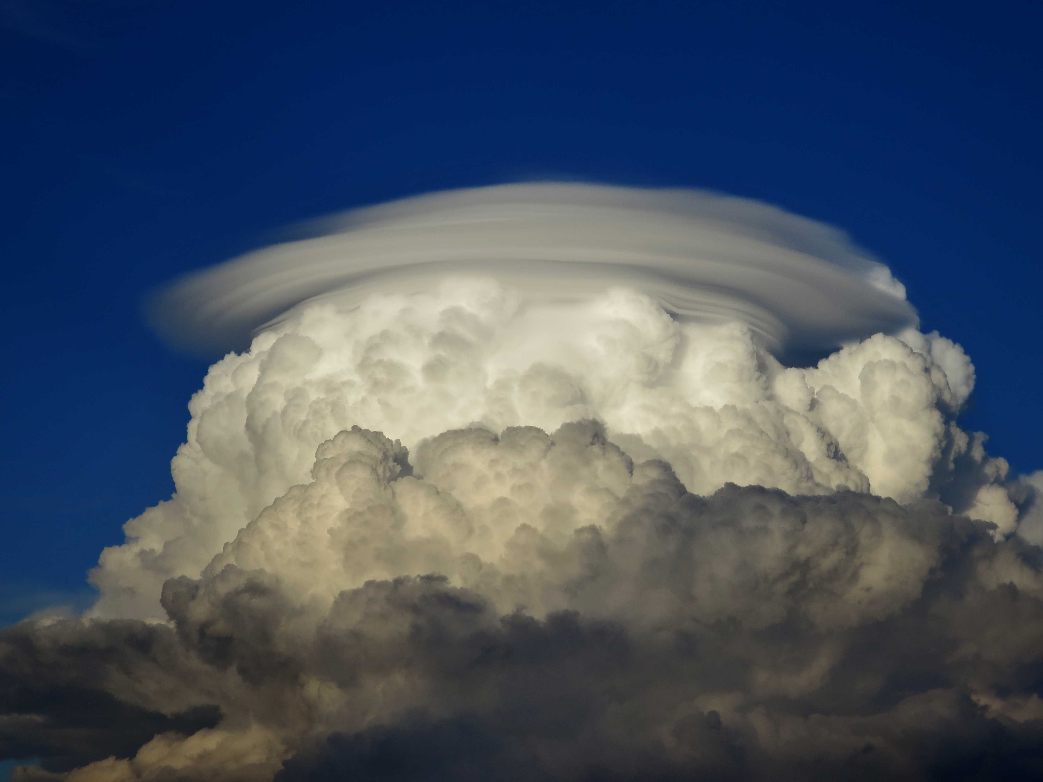
Cumulonimbus calvus pileus
The cauliflower appearance of the lower part of this cloud is indicative of Cumulus congestus. However, the upper part is losing its sharp outlines and definition, making this a Cumulonimbus cloud, species calvus. An excellent example of accessory cloud pileus caps the Cumulonimbus as a whole. Pileus is generally of small horizontal extent, forming a cap or hood that is above the top or attached to the upper part of the cumuliform cloud that often penetrates it. As in this image, several superimposed layers, such as those at 4 and 5, may often be seen. Pileus is formed by the condensation of moist air above a rapidly growing cumuliform cloud and is short-lived.
Links in the image description will highlight features on the image. Mouse over the features for more detail.
© Sylke BoydHodges Township, Minnesota, United States of AmericaLatitude: 45° 33' 37'' NLongitude: 95° 50' 1'' W09 September 2015 1814 (Local Time)Camera direction: towards NECL = 3, CM = 0, CH = 0Image P/S code: P.10.12Image I.D.: 4770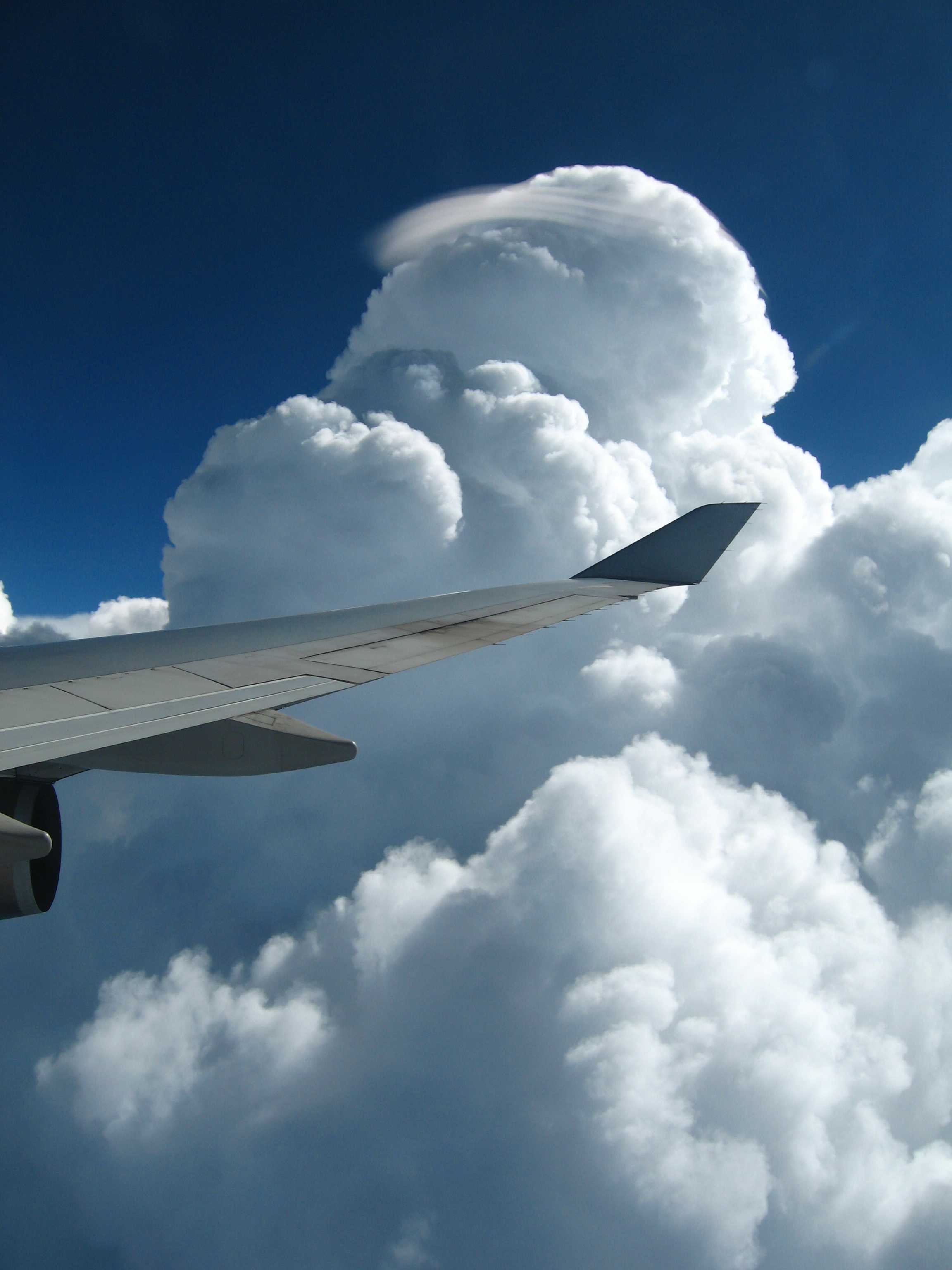
Cumulonimbus calvus with pileus
Cumulonimbus are heavy, dense clouds of considerable vertical extent, in the form of a mountain or huge towers. In this image we see the species calvus, in which at least part of the upper portion is usually smooth, fibrous or striated, and nearly always flattened. In front of the highest portion of the calvus, the sproutings have sharper outlines and the cauliflower appearance of Cumulus congestus. Also visible is a pileus accessory cloud; these clouds occasionally form above rapidly developing convective clouds. They have a smooth appearance and are of small horizontal extent in the form of a cap or hood attached to the upper part of the main cloud. Pileus, which is not long-lasting, is formed by strong updrafts acting on moist air above, causing the air to cool to its dew point.
Links in the image description will highlight features on the image. Mouse over the features for more detail.
© Stephen BurtPenang, MalaysiaLatitude: 5° 24' 51'' NLongitude: 100° 19' 44'' E14 May 2007 1637 (Local Time)Image P/S code: S.10.12 1Image I.D.: 4726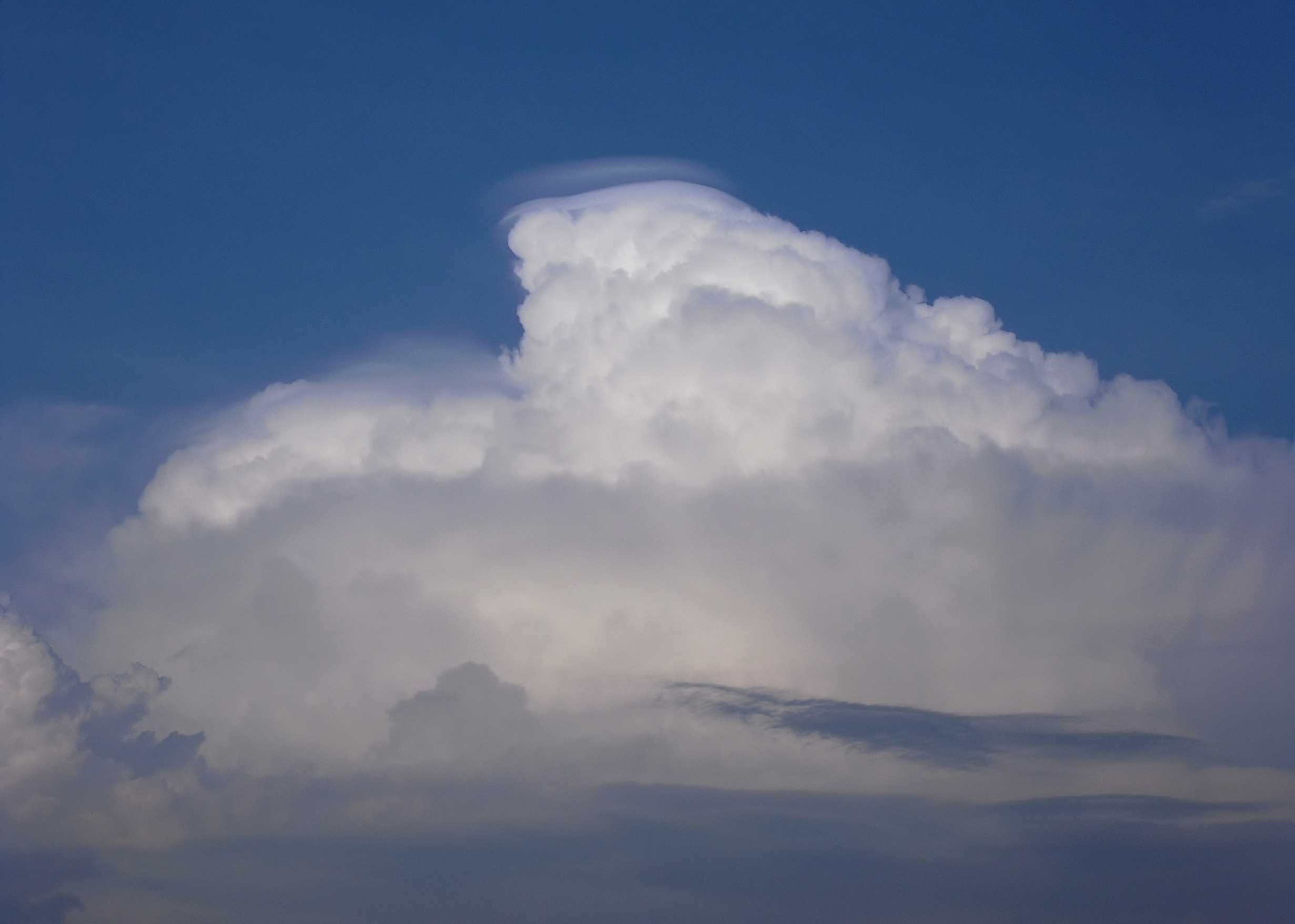
Cumulonimbus calvus with pileus
The image shows Cumulonimbus. The top part of the cloud is becoming flattened and indistinct, indicating the species calvus. At the top of the Cumulonimbus are smooth, cap-like clouds (at 2 and 3); these are the supplementary feature pileus, which can form above the vigorous updraughts in the cloud. There is a suggestion of irisation in the lower and less distinct patch of pileus. Isolated patches of Altocumulus are present, most likely formed from spreading of part of the Cumulonimbus.
Thunder could be heard at the time of the image and a thunderstorm with rain was observed about an hour earlier.
Links in the image description will highlight features on the image. Mouse over the features for more detail.
© Frank Le BlancqJersey Airport, St Peter, JerseyLatitude: 49° 12' 25'' NLongitude: 2° 11' 52'' W06 May 2011 1915 (Local Time)Camera direction: towards ENECL = 3, CM = 6, CH = 0Image P/S code: S.10.12 4Image I.D.: 5129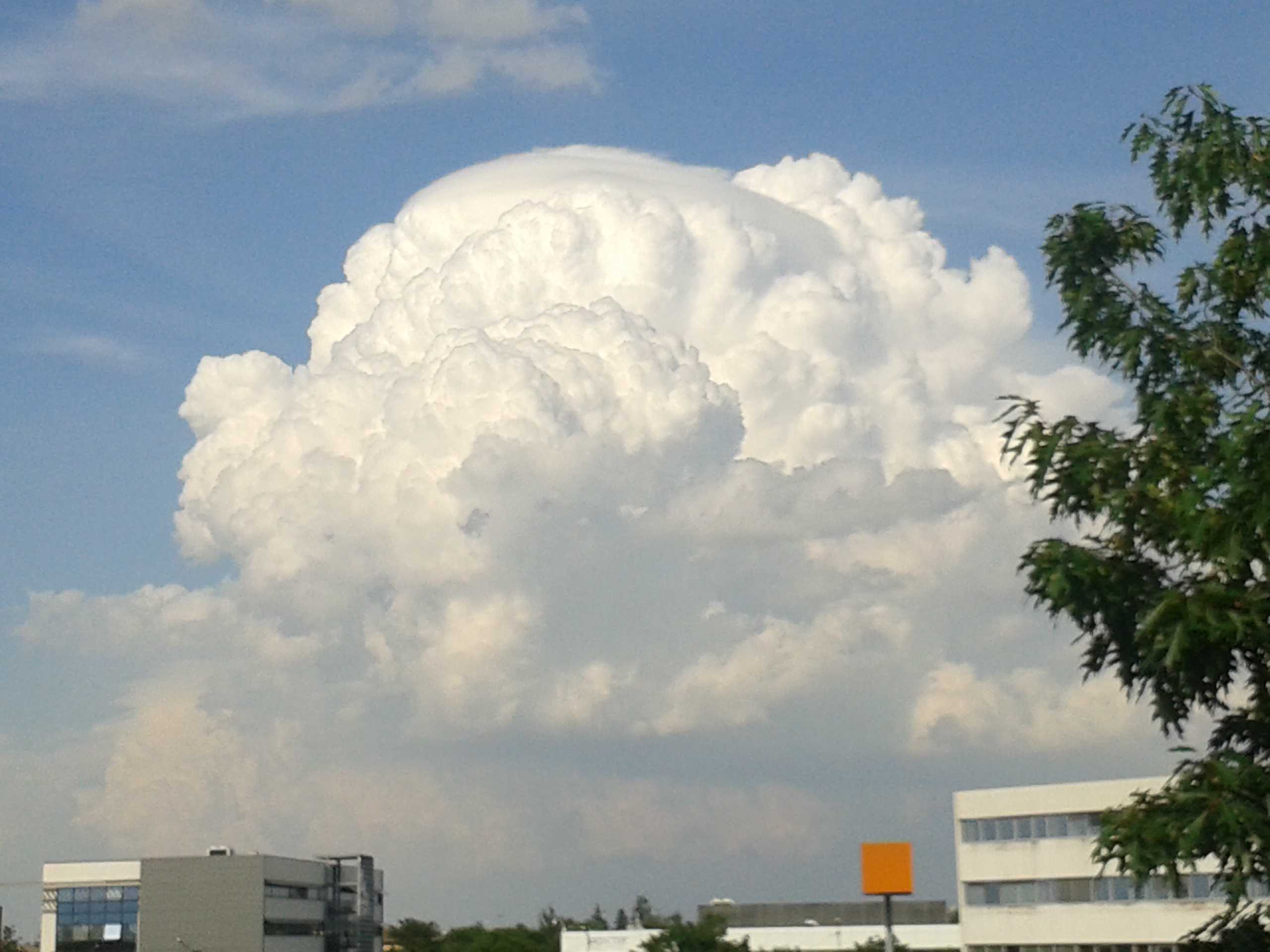
Cumulonimbus calvus pileus
This cumuliform cloud appears to be intermediate between Cumulus congestus and Cumulonimbus calvus. It is Cumulonimbus calvus as some of the upper parts are more or less indistinct and are starting to have the appearance of a whitish mass without sharp outlines.
It is important that the accessory cloud pileus not be mistaken for flattening of the cumuliform top or for confirmation of a whitish mass without sharp outlines.
Links in the image description will highlight features on the image. Mouse over the features for more detail.
© Joris VallonToulouse, FranceLatitude: 43° 34' 29'' NLongitude: 1° 22' 42'' E28 June 2014 1811 (Local Time)Camera direction: towards NECL = 3, CM = /, CH = /Image P/S code: S.10.12 2Image I.D.: 5962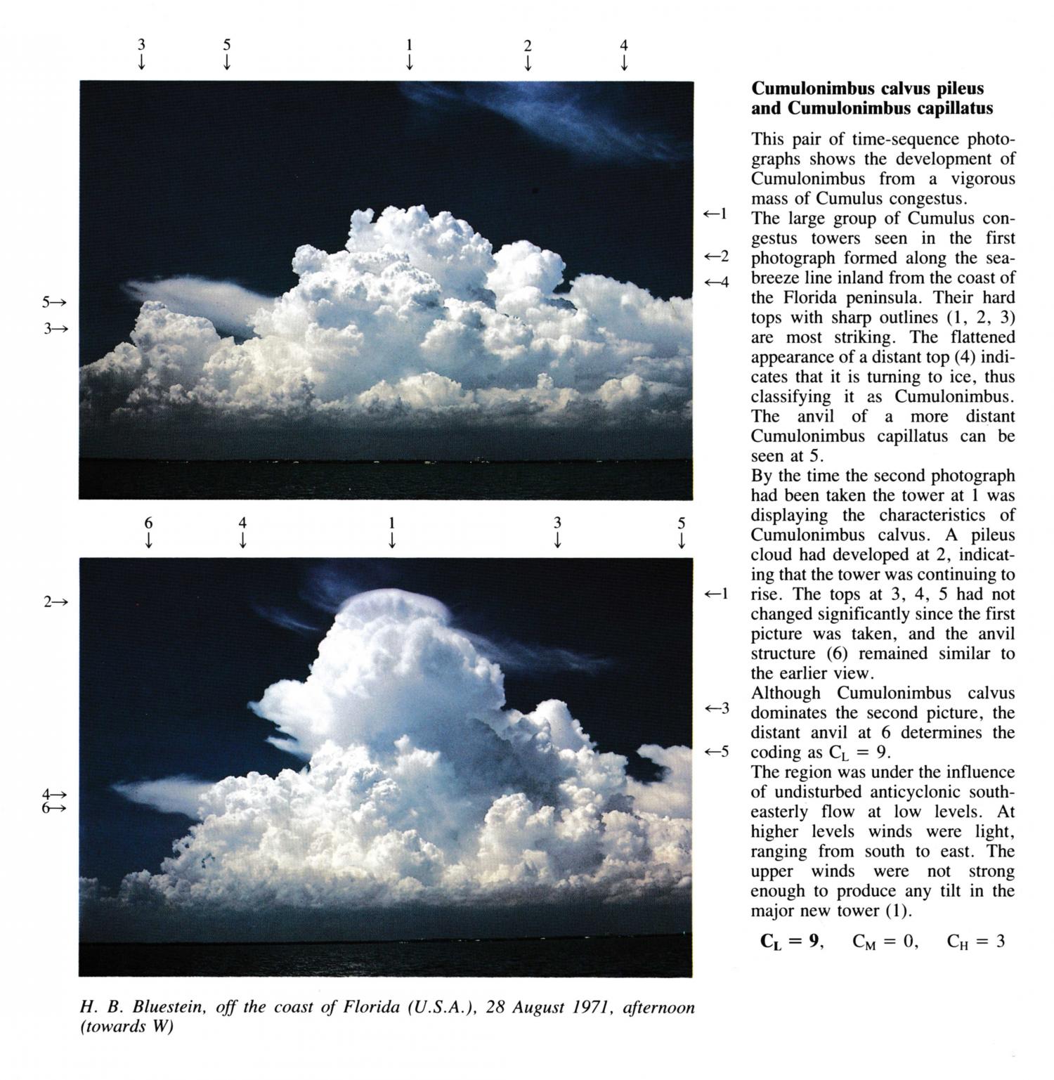
Cumulonimbus calvus pileus and Cumulonimbus capillatus
(NB. Latitude, Longitude and hour of day estimated)
By the time this second photograph had been taken the tower at 1 was displaying the characteristics of Cumulonimbus calvus. A pileus cloud had developed at 2, indicating that the tower was continuing to rise. The tops at 3, 4, 5 had not changed significantly since the first picture was taken, and the anvil structure remained similar to the earlier view. Although Cumulonimbus calvus dominates the second picture, the distant anvil at 6 determines the coding as CL = 9.
The region was under the influence of undisturbed anticyclonic south-easterly flow at low levels. At higher levels winds were light, ranging from south to east. The upper winds were not strong enough to produce any tilt in the major new tower.
Links in the image description will highlight features on the image. Mouse over the features for more detail.
© H.B. BluesteinOff the coast of Florida, United States of AmericaLatitude: 27° 43' 56'' NLongitude: 79° 54' 13'' W28 August 1971 1415 (Local Time)Camera direction: towards WCL = 9, CM = 0, CH = 3