© Matthew Clark
Weston Mouth, Salcombe Regis, United Kingdom of Great Britain and Northern Ireland
Latitude: 50° 41' 1'' N
Longitude: 3° 11' 56'' W
06 May 2013 1230 (Local Time)
Camera direction: towards ESE
Image P/S code: P.11.1.1.4
Image I.D.: 5025
-
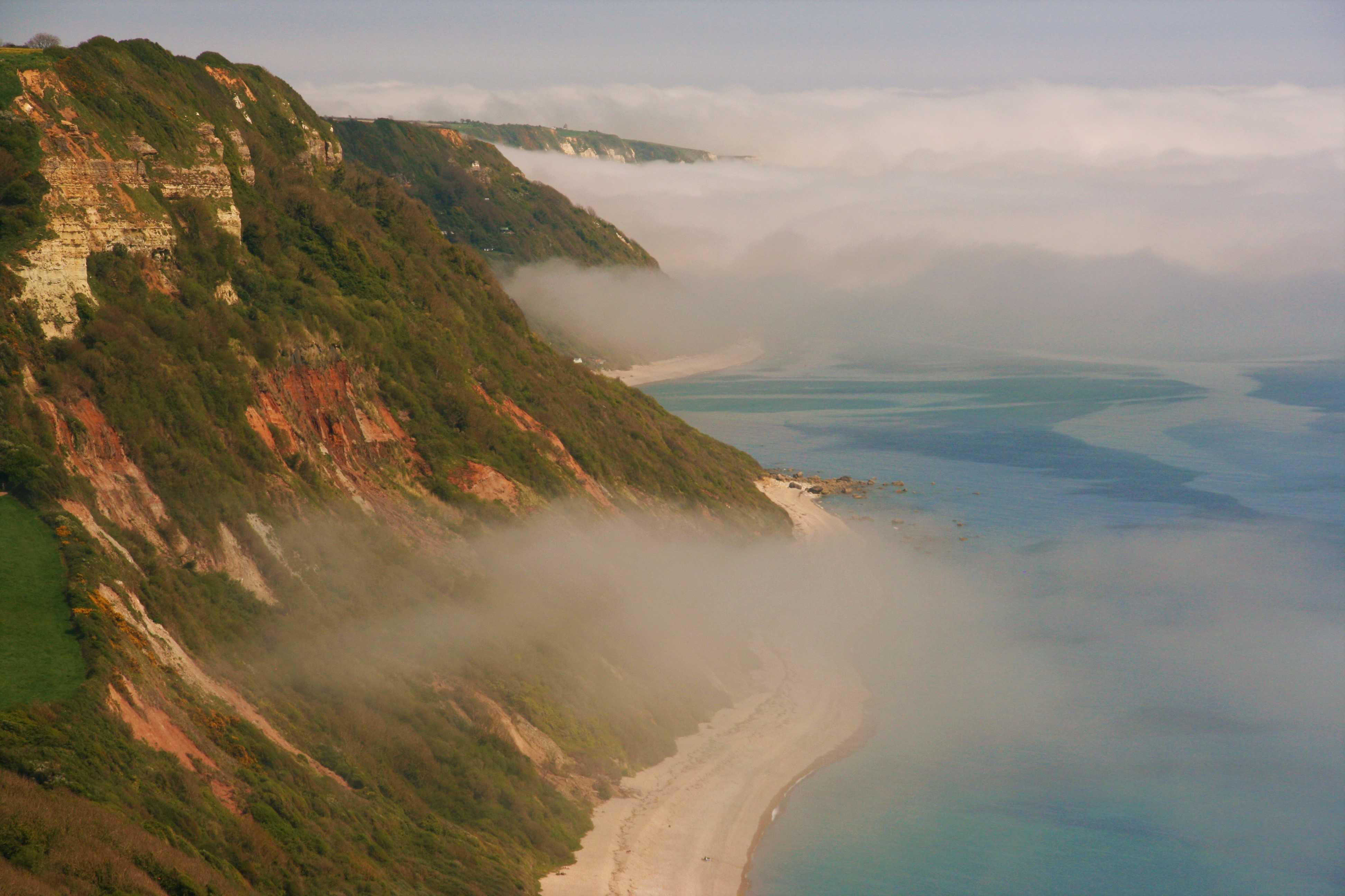
Advection fog/sea fog
Advection fog is formed when relatively warm, moist air moves (advects) over a cooler surface and the temperature of the air is cooled to saturation by contact with the cold surface. One example of advection fog is sea fog.
This picture shows sea fog at Weston Mouth, Devon, England, UK. It formed as a relatively moist air mass was advected over the relatively cool waters of the English Channel.
In the foreground, on the edge of the bank of sea fog, the cloud has lifted off the surface to form a low Stratus.
Links in the image description will highlight features on the image. Mouse over the features for more detail.
© Matthew ClarkWeston Mouth, Salcombe Regis, United Kingdom of Great Britain and Northern IrelandLatitude: 50° 41' 1'' NLongitude: 3° 11' 56'' W06 May 2013 1230 (Local Time)Camera direction: towards ESEImage P/S code: P.11.1.1.4Image I.D.: 5025
Advection fog/sea fog from the air
This view from the air over south-west England, UK shows extensive sea fog/low Stratus covering a large part of Lyme Bay in the English Channel. Sea fog is a type of advection fog and is formed when relatively warm, moist air moves (advects) over a cooler sea surface and the temperature of the air near the surface is cooled to saturation by contact with the cooler water.
The fog was confined to the sea and immediate coastline, lifting into low Stratus and readily dissipating inland.
Links in the image description will highlight features on the image. Mouse over the features for more detail.
© Ian SimpsonLanherne (E-bound), Dawlish, Devon, United Kingdom of Great Britain and Northern IrelandLatitude: 50° 34' 56'' NLongitude: 3° 27' 52'' W06 May 2013 1100 (Local Time)Camera direction: towards SEImage P/S code: S.11.1.1.4 5Image I.D.: 5032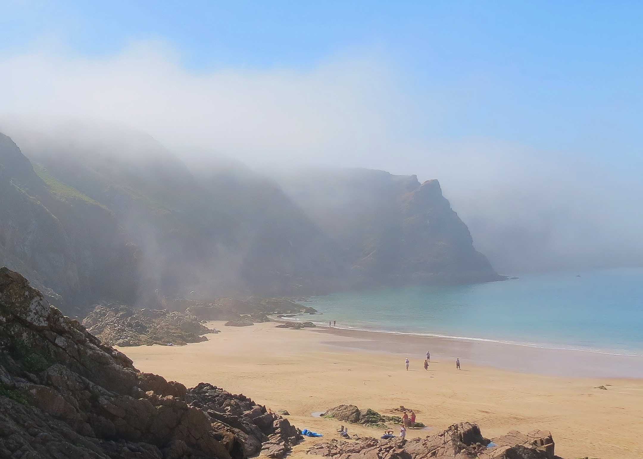
Advection fog/sea fog
The image shows sea fog advecting on to the coast. Thick fog had formed in a moist air mass over a relatively cool sea (17 °C) and can be seen on the right. As the land heated during the day to 27 °C at the time of the image, coastal breezes developed in a slack pressure gradient, advecting the fog over the coastline. The cliffs allow the fog depth to be estimated at 50 to 100 m (200 to 250 ft), with clear sky above.
Links in the image description will highlight features on the image. Mouse over the features for more detail.
© Frank Le BlancqPlémont Bay, JerseyLatitude: 49° 15' 21'' NLongitude: 2° 13' 52'' W04 September 2013 1426 (Local Time)Camera direction: towards WNWImage P/S code: S.11.1.1.4 1Image I.D.: 5076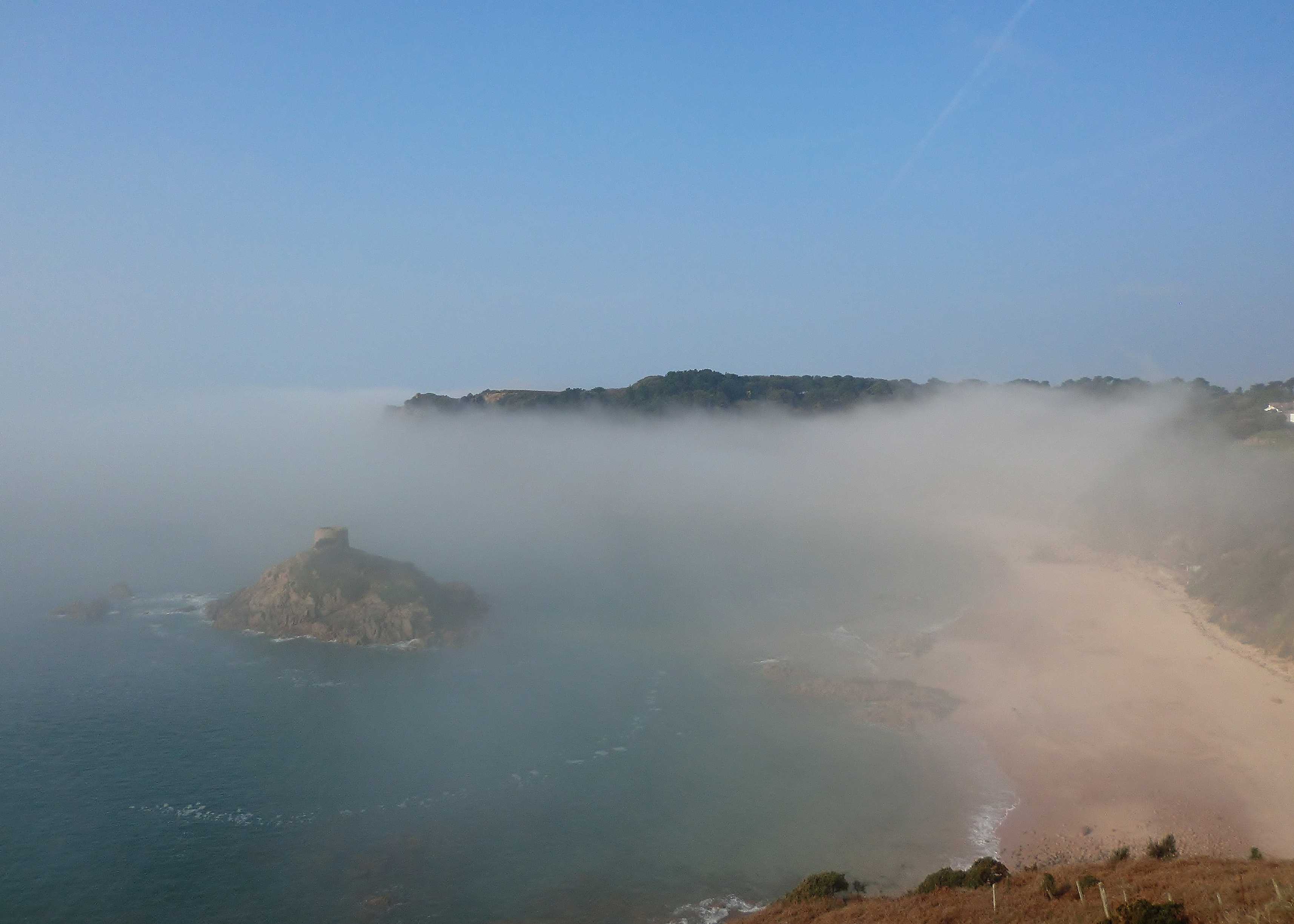
Sea fog/advection fog
In this image, sea fog is advecting onto the coast. Thick fog has formed over the sea (temperature 8 °C) and shrouds the headland behind the tower. A slightly warmer land temperature (about 10 °C) has created a light coastal breeze, advecting the fog inland, where it is thinning immediately in front of the photographer. The headland enables the depth of the fog to be estimated at about 50 m (150 ft), which is consistent with a representative sounding that shows a very sharp and shallow inversion.
Links in the image description will highlight features on the image. Mouse over the features for more detail.
© Frank Le BlancqPortelet Bay, St Brelade, JerseyLatitude: 49° 10' 17'' NLongitude: 2° 10' 27'' W01 March 2012 1010 (Local Time)Camera direction: towards WSWImage P/S code: P.11.1.1.4.1Image I.D.: 5126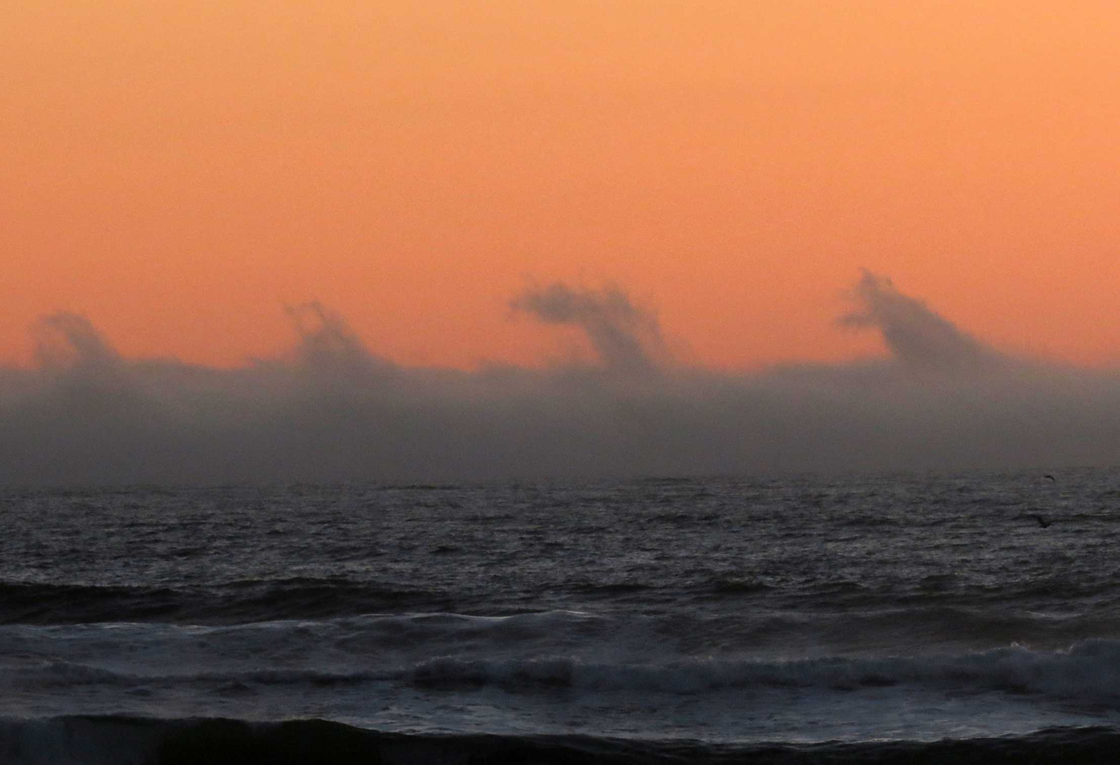
Sea fog with fluctus
This view from San Francisco, California, USA, just after sunset, shows sea fog over the Pacific Ocean. On the fog top are curls or breaking waves known as Kelvin-Helmholtz waves (fluctus) (seen at 2 and 3).
Sea fog is a type of advection fog and is formed when relatively warm, moist air moves over a cooler sea surface. The temperature of the air is cooled to saturation by contact with the cold surface.
Fluctus is a relatively short-lived wave formation caused by wind shear across the top of the fog.
Links in the image description will highlight features on the image. Mouse over the features for more detail.
© Mila ZinkovaSan Francisco, California, United States of AmericaLatitude: 37° 46' 37'' NLongitude: 122° 30' 43'' W26 March 2015 1931 (Local Time)Camera direction: towards WImage P/S code: S.11.1.1.4 4Image I.D.: 5459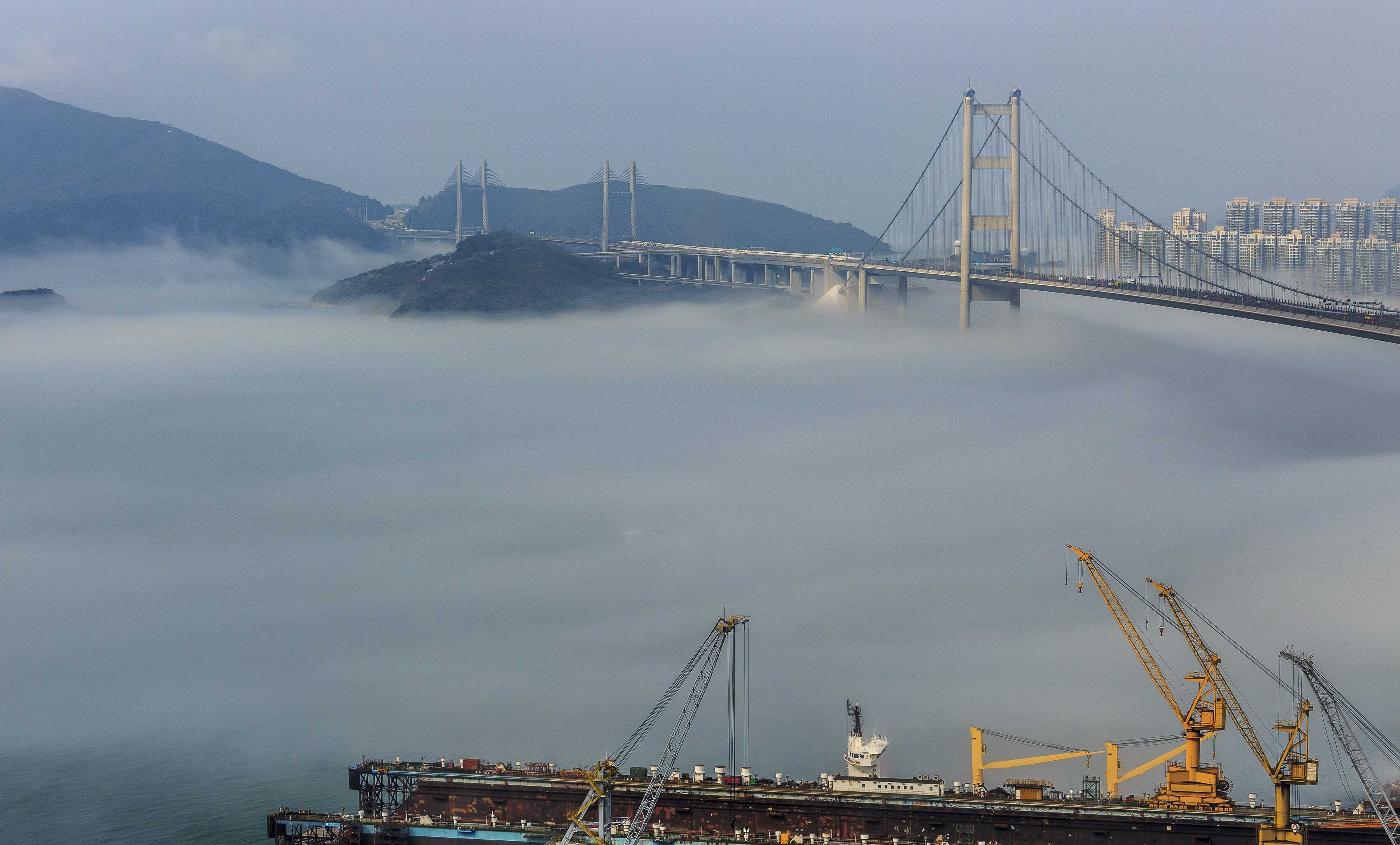
Sea fog/advection fog
Sea fog is a type of advection fog and is formed when relatively warm, moist air moves over a cooler sea surface. The temperature of the air is cooled to saturation by contact with the cold surface.
In this picture, sea fog is seen over the Ma Wan Channel and underneath the bridge that spans it in Hong Kong (China). The fog is less than 60 m deep. Hong Kong was under the influence of a humid maritime airstream, but a cold front was approaching from the north.
Links in the image description will highlight features on the image. Mouse over the features for more detail.
© Pong LeungTsing Ma Bridge, Hong Kong, ChinaLatitude: 22° 21' 4'' NLongitude: 114° 4' 24'' E14 February 2016 0945 (Local Time)Image P/S code: S.11.1.1.4 3Image I.D.: 5679