© Martin Gudd
Bad Kreuznach, Germany
Latitude: 49° 50' 39'' N
Longitude: 7° 50' 32'' E
07 December 2015 1614 (Local Time)
Camera direction: towards W
Image P/S code: P.1.17
Image I.D.: 5490
CL = 0, CM = 3, CH = 1
-

Cirrus uncinus cirrocumulogenitus, Cirrocumulus castellanus undulatus and floccus with virga
Cirrocumulus and Cirrus are the two main cloud types here in what seems to be a confused sky. The saw-toothed, very small turrets rising from common bases are Cirrocumulus castellanus; these bases are arranged partly in parallel lines and are suggestive of the variety undulatus, which is confirmed by observation of easterly winds at the estimated height of the cirriform clouds. In some parts, Cirrocumulus floccus is evolving from the castellanus, where ice crystal virga has dissipated the base of the latter. The Cirrocumulus floccus is gradually developing into hook-like commas (Cirrus uncinus). At the top of the image there are also irregularly curved filaments (Cirrus fibratus). In summary, there is more Cirrus uncinus and fibratus present than Cirrocumulus, hence the coding of CH = 1.
There is also a patch of Altocumulus present and at least four contrails, seen at 6, 7 and 8. The location was in warm air, under the influence of a very weak short-wave upper-tropospheric trough.
Links in the image description will highlight features on the image. Mouse over the features for more detail.
© Martin GuddBad Kreuznach, GermanyLatitude: 49° 50' 39'' NLongitude: 7° 50' 32'' E07 December 2015 1614 (Local Time)Camera direction: towards WCL = 0, CM = 3, CH = 1Image P/S code: P.1.17Image I.D.: 5490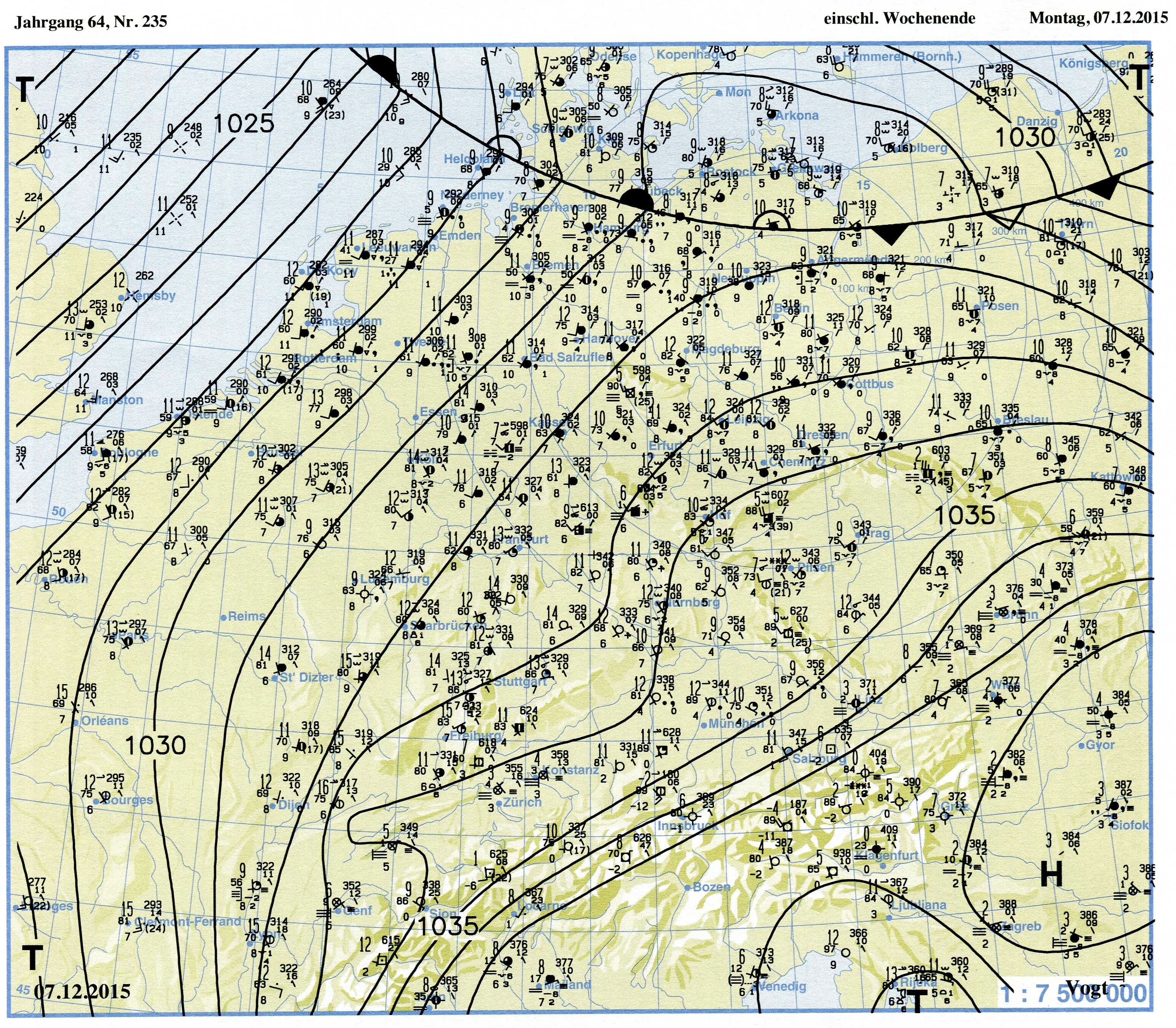
The synoptic chart shows the situation about three hours before the photo was taken. Great parts of Germany were under warm air from south-western Europe. Temperatures in the afternoon generally exceeded 10 °C. Within this warm air, some high and middle clouds developed and drifted from south to north, due to a weak upper-tropospheric short-wave trough.
© Verein Berliner Wetterkarte e.V.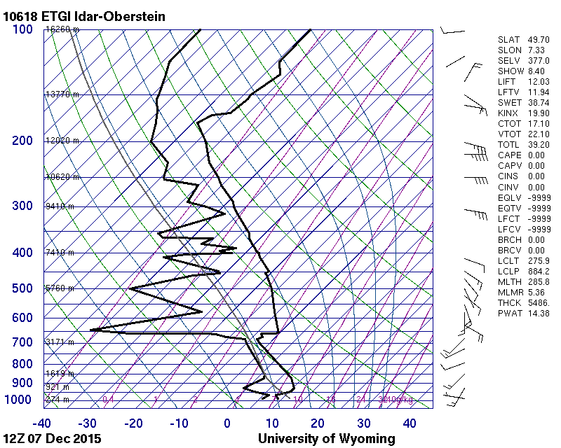 Sounding has discrete layers of moisture at 7 600 and 9 200 m.© University of Wyoming
The picture shows the situation some hours before the photo was taken. There are two main frontal systems: a warm front, stretching from Iceland over the North Sea to the northern parts of Germany; and a cold front, stretching southward from Iceland to Ireland and the Bay of Biscay. Large parts of Germany are under the influence of warm south-westerlies, in which some middle- and high-level cloud developed. A weak upper-tropospheric short-wave trough produced the small patch of middle- and high-level cloud over Benelux and western parts of Germany. There was no precipitation from this cloud.
© Verein Berliner Wetterkarte e.V.
Cirrus uncinus cirrocumulogenitus and Cirrocumulus floccus
The predominate cloud in this image is Cirrus uncinus. The uncinus is white and is in the shape of a comma with the top terminating in the form of a hook or in a tuft, the upper part of which is not in the form of a rounded protuberance.
Also present is Cirrocumulus floccus, from which the Cirrus uncinus has developed. The Cirrocumulus floccus is evident as several thin white patches of very small elements, of which some of the lower parts are ragged.
Cirrus fibratus is also developing where the wind has distorted the uncinus commas into irregularly curved or nearly straight filaments.
Links in the image description will highlight features on the image. Mouse over the features for more detail.
© Rob LindbergMeridian, Idaho, United States of AmericaLatitude: 43° 35' 57'' NLongitude: 116° 25' 24'' W09 June 2015 0830 (Local Time)Camera direction: towards SSWCL = 0, CM = 0, CH = 1Image P/S code: S.1.17Image I.D.: 4806