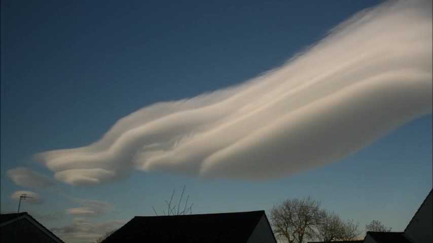
© Matthew Clark
Burley in Wharfedale, West Yorkshire, United Kingdom of Great Britain and Northern Ireland
Latitude: 53° 54' 41'' N
Longitude: 1° 45' 30'' W
22 December 2011 1425 (Local Time)
Camera direction: towards N
Image P/S code: P.19.3.2
Image I.D.: 5508
CL = 1, CM = 4, CH = 0
-

Yorkshire, England, UK Altocumulus lenticularis time lapse
This is a time lapse of Altocumulus lenticularis clouds that formed over and immediately to the lee of the Yorkshire Pennines, England, UK. The time lapse covers the period from 1425 to 1515 UTC on 22 December 2011. The clouds formed within the broad warm sector of a depression centred near 60°N 26°W. This depression was characterized by a stable west to south-westerly flow, with anticyclonic curvature around the northern flank of a 1 034 hPa anticyclone that was centred over the Bay of Biscay. The largest cloud formed a near-stationary, north-south orientated band whose axis was displaced some 20–30 km east of the highest Pennine hills in the Yorkshire Dales. Contrasting with the quasi-stationary Altocumulus, small patches of Stratocumulus and Stratus fractus can be seen moving rapidly eastwards in the strong westerly flow.
Satellite imagery indicated cloud top heights in the range of 6 000 m (20 000 ft) to more than 7 500 m (25 000 ft). The clouds were sampled by the UK Met Office laser cloud base recorders at Dishforth and Linton-on-Ouse, England, UK. They indicated cloud base heights in the range of 5 200 to 5 500 m (17 000 to 18 000 ft). The clouds were visible over a large part of northern England following the dissipation of a lower layer of Stratocumulus clouds during the morning.
Links in the image description will highlight features on the image. Mouse over the features for more detail.
© Matthew ClarkBurley in Wharfedale, West Yorkshire, United Kingdom of Great Britain and Northern IrelandLatitude: 53° 54' 41'' NLongitude: 1° 45' 30'' W22 December 2011 1425 (Local Time)Camera direction: towards NCL = 1, CM = 4, CH = 0Image P/S code: P.19.3.2Image I.D.: 5508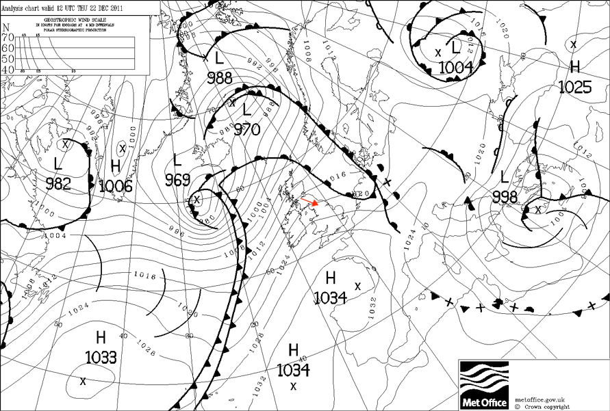
Surface analysis chart for 1200 UTC on 22 December 2011 – UK is situated within a broad warm sector characterized by westerly flow with anticyclonic curvature.
© Crown Copyright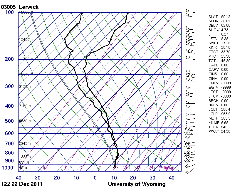
The 1200 UTC Lerwick, Scotland, UK radiosonde ascent data shows a moist and stable profile through much of the depth of the troposphere, with strong westerly winds increasing in strength with height.
© University of Wyoming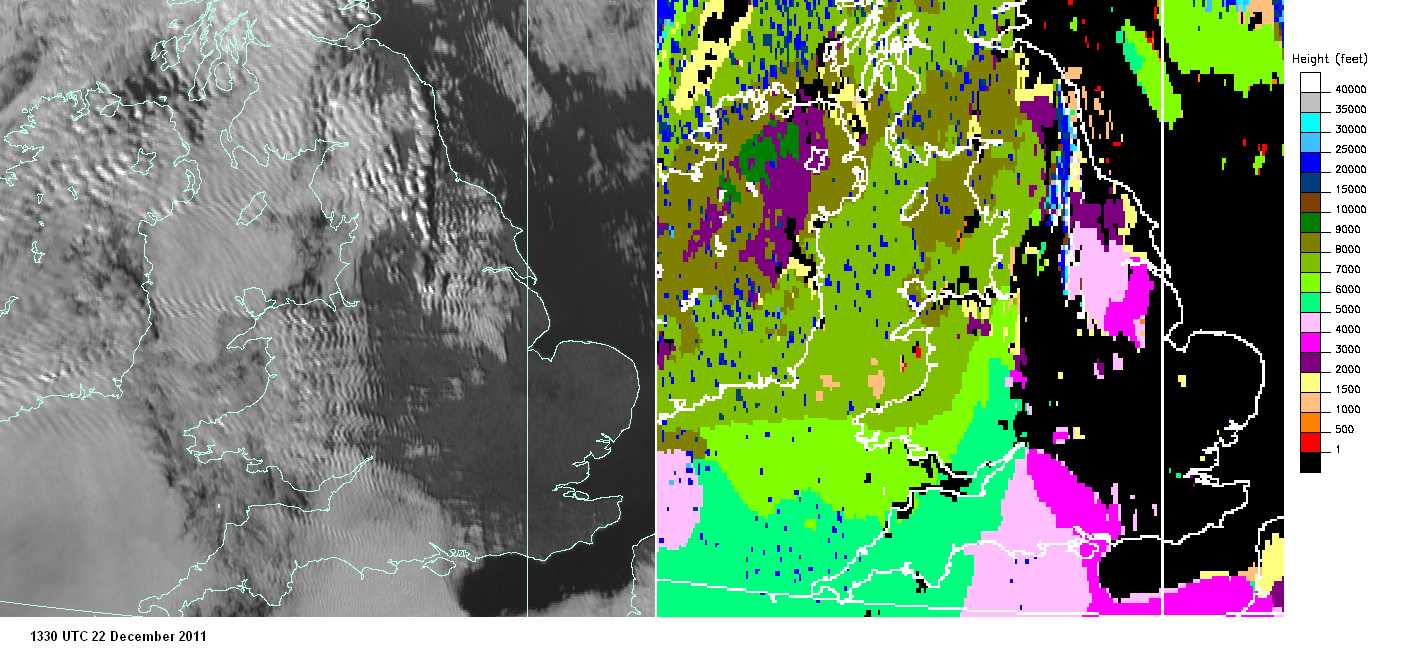
This is visible satellite imagery (left) and satellite-derived cloud top heights (right) from 1330 UTC on 22 December 2011. In the visible imagery, the Altocumulus lenticularis clouds are not easily distinguishable from surrounding Stratocumulus clouds, but their location is revealed by the distinct shadow cast to the east of the clouds, standing out as a narrow, north-south orientated dark band extending from Northumberland to North Yorkshire, England, UK. The Altocumulus clouds are easily distinguishable in the cloud top height imagery by their cloud top heights of over 6 000 m (20 000 ft) – much higher than the approximately 7 000-ft (2 100 m) tops associated with the Stratocumulus to the west over Cumbria, England, UK and the approximately 2 000- to 4 000-ft (600 to 1 200 m) tops of Stratus and Stratocumulus to the east over other parts of Yorkshire.
© EUMETSAT, 2011 / Met Office