© Michael Bruhn
Mordialloc, Victoria, Australia
Latitude: 38° 0' 34'' S
Longitude: 145° 5' 8'' E
07 December 2016 1134 (Local Time)
Camera direction: towards SSW
Image P/S code: P.1.1
Image I.D.: 5630
CL = 0, CM = 3, CH = 1
-
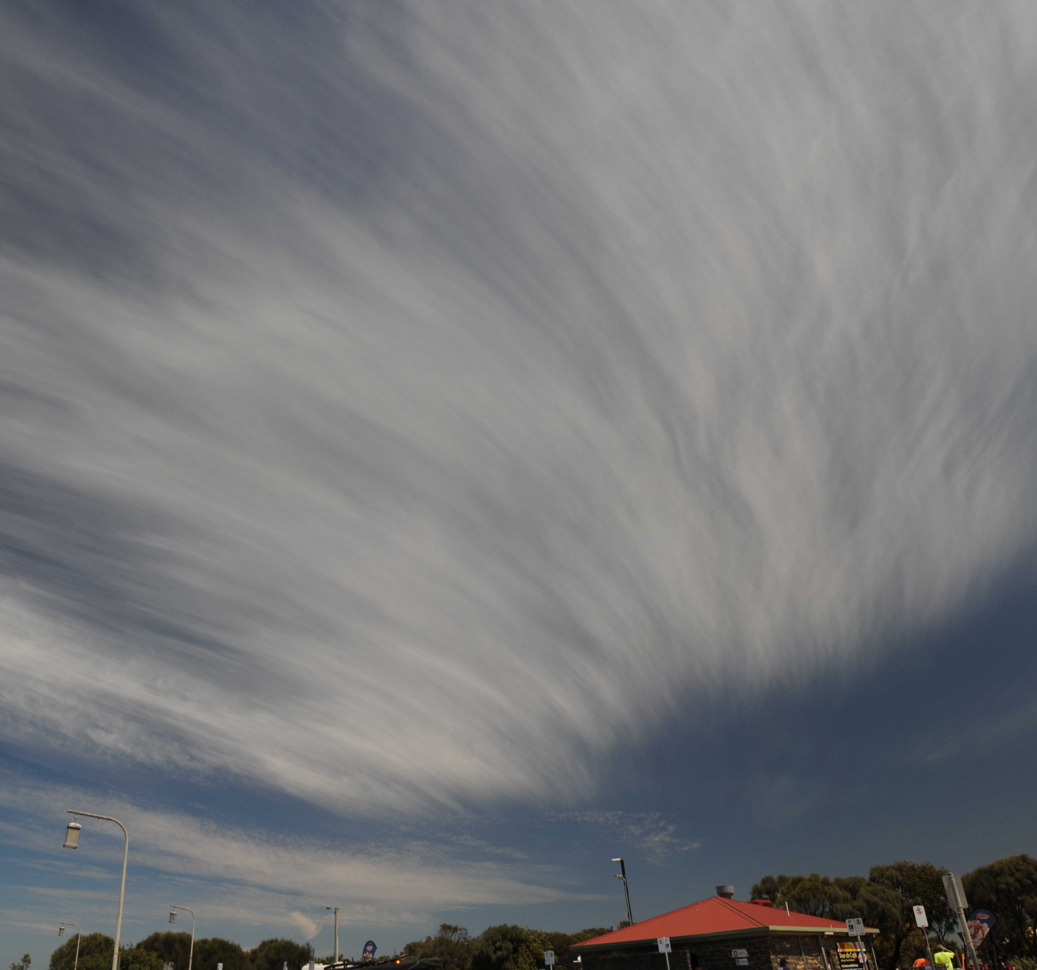
Thick field of Cirrus fibratus and Cirrus uncinus
This thick field of Cirrus fibratus developed in situ. The filaments are nearly straight on the left side of the image and becoming irregularly curved and entangled on the right side. The Cirrus was starting to thicken but is not identified as spissatus as the filaments were very distinctive and it was not sufficiently dense to appear greyish. Tufted Cirrus of the species uncinus was developing on the downwind edge and short-lived ice crystal virga was forming from small patches of Altocumulus on the horizon.
Links in the image description will highlight features on the image. Mouse over the features for more detail.
© Michael BruhnMordialloc, Victoria, AustraliaLatitude: 38° 0' 34'' SLongitude: 145° 5' 8'' E07 December 2016 1134 (Local Time)Camera direction: towards SSWCL = 0, CM = 3, CH = 1Image P/S code: P.1.1Image I.D.: 5630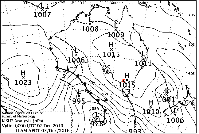
A weak trough passed to the south of the area.
© Commonwealth of Australia 2016, Bureau of Meteorology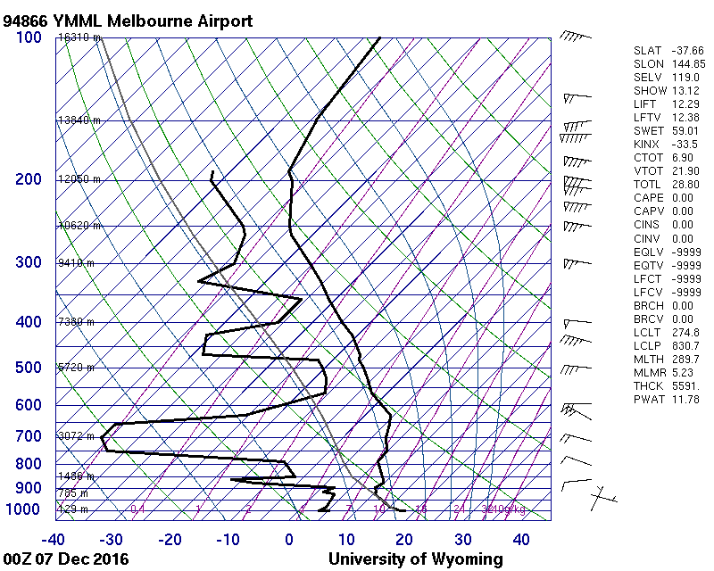
The sounding shows middle-level moisture from 4 800 to 6 000 m and a spike of high-level moisture at 8 200 m.
© University of Wyoming
Cirrus fibratus and uncinus
A spectacular example of the two most common Cirrus species: fibratus and uncinus. Both species are present as white, delicate, hair-like filaments; the fibratus consists of nearly straight filaments and also of more or less irregularly curved filaments. The uncinus is shaped like a comma and terminates at the top in a hook and, in some places, a tuft. Cumulus humilis radiatus is low on the horizon and some Cumulus humlis and fractus patches are also present. On the morning the photograph was taken, there was a steady increase in high cloud following the passage of a weak cold front during the night. The Cirrus developed into Cirrostratus nebulosus during the afternoon.
Links in the image description will highlight features on the image. Mouse over the features for more detail.
© Stephen BurtStratfield Mortimer, near Reading, Berkshire RG7, United Kingdom of Great Britain and Northern IrelandLatitude: 51° 22' 12'' NLongitude: 1° 2' 24'' W25 June 2014 1026 (Local Time)Camera direction: towards SWCL = 1, CM = 0, CH = 1Image P/S code: S.1.1 4Image I.D.: 4728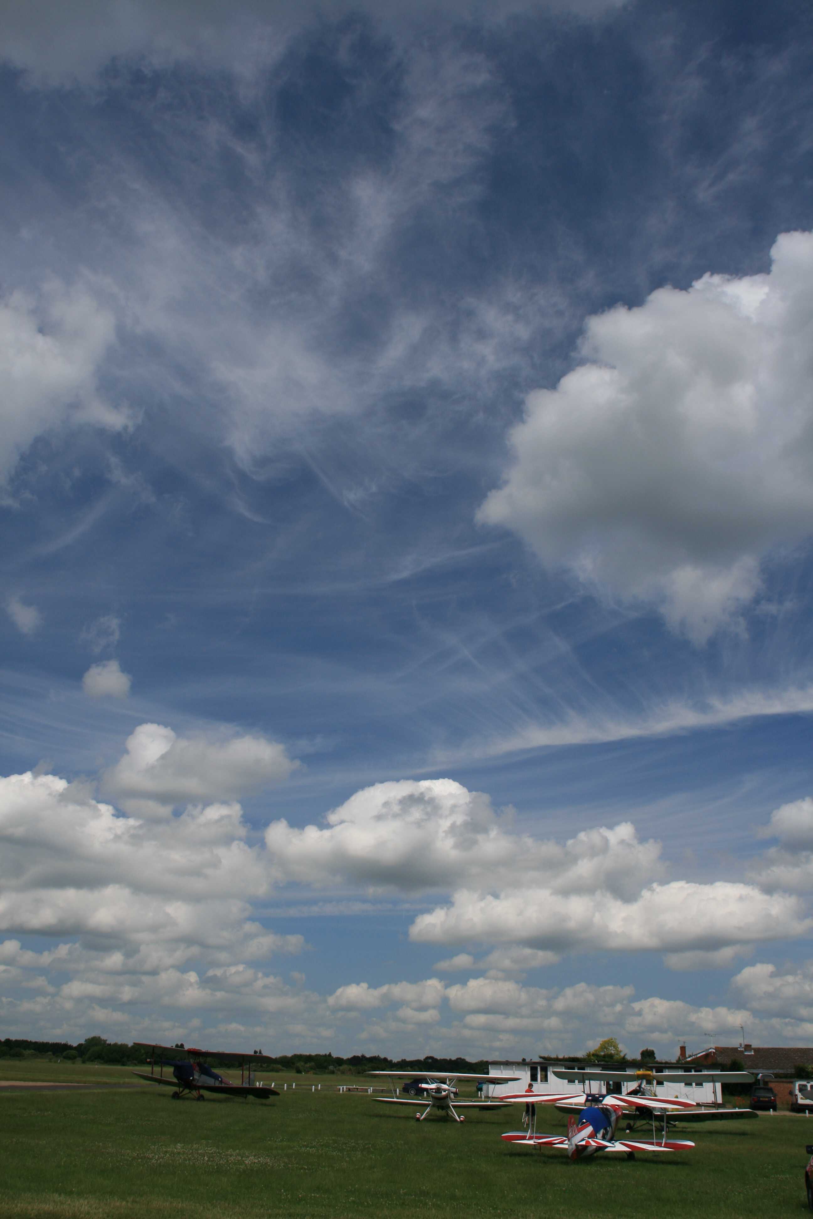
Cirrus fibratus vertebratus duplicatus and Cumulus humilis
Two layers of Cirrus fibratus can be seen. The lower layer comprises slightly entangled, irregularly curved filaments at the top of the photo and a line where the filaments are arranged in a manner suggestive of one side of a fish skeleton. The latter is the variety vertebratus. The higher layer is composed of nearly straight and some irregularly curved filaments. The presence of multiple Cirrus layers indicates the variety duplicatus. The lower, detached, rounded cells with shaded bases are Cumulus humilis. They are of small vertical extent but do not appear as if flattened. Further development in the vertical may see some become Cumulus mediocris.
Links in the image description will highlight features on the image. Mouse over the features for more detail.
© Stephen BurtWhite Waltham, Maidenhead, United Kingdom of Great Britain and Northern IrelandLatitude: 51° 29' 59'' NLongitude: 0° 46' 4'' W14 June 2009 1107 (Local Time)Camera direction: towards NWCL = 1, CM = 0, CH = 1Image P/S code: S.1.1 5Image I.D.: 4986
Cirrus fibratus radiatus and Cumulus humilis
The main feature of this image is a long band of Cirrus fibratus aligned north-west to south-east, parallel to the observed north-west winds at height. The individual fibrataus filaments are transverse to the wind; they have the appearance of being arranged in a manner suggestive of vertebrae, ribs or a fish skeleton. This is the variety vertebratus.
On the satellite image, the Cirrus fibratus vertebratus band is over 900 km long. There are also several much smaller bands in this image; all the bands appear to be converging toward a point on the horizon. This is the supplementary feature radiatus.
Cumulus humilis is also present, as are several contrails (at 6 and 7).
Links in the image description will highlight features on the image. Mouse over the features for more detail.
© Stephen BurtChilbolton Down, Hampshire SO20 6DE, United Kingdom of Great Britain and Northern IrelandLatitude: 51° 7' 43'' NLongitude: 1° 25' 12'' W27 June 2010 1514 (Local Time)Camera direction: towards NWCL = 1, CM = 0, CH = 1Image P/S code: S.1.1 30Image I.D.: 5002
Cirrus fibratus and floccus
Nearly straight filaments of very high and fine Cirrus fibratus dominate this image. Some indistinct Cirrus floccus is dissipating in the top right corner. One Cumulus fractus of good weather is trying to hide on the bottom right.
Links in the image description will highlight features on the image. Mouse over the features for more detail.
© Michael BruhnAspendale Gardens, Victoria, AustraliaLatitude: 37° 48' 37'' SLongitude: 144° 57' 16'' E03 December 2016 1401 (Local Time)Camera direction: towards ECL = 1, CM = 0, CH = 1Image P/S code: S.1.1 2Image I.D.: 5629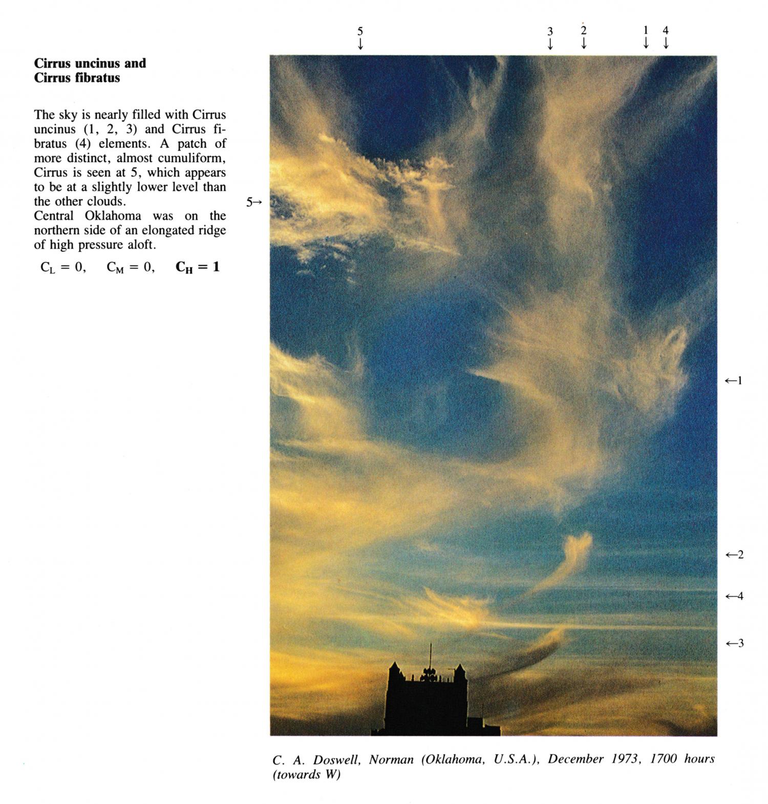
Cirrus uncinus and Cirrus fibratus
(NB: Date in December estimated)
The sky is nearly filled with Cirrus uncinus(1, 2, 3) and Cirrus fibratus elements. A patch of more distinct, almost cumuliform, Cirrus is seen at 5, which appears to be at a slightly lower level than the other clouds. Central Oklahoma was on the northern side of an elongated ridge of high pressure aloft.
Links in the image description will highlight features on the image. Mouse over the features for more detail.
© C.A. DoswellNorman, Oklahoma, United States of AmericaLatitude: 35° 13' 21'' NLongitude: 97° 26' 22'' W15 December 1973 1700 (Local Time)Camera direction: towards WCL = 0, CM = 0, CH = 1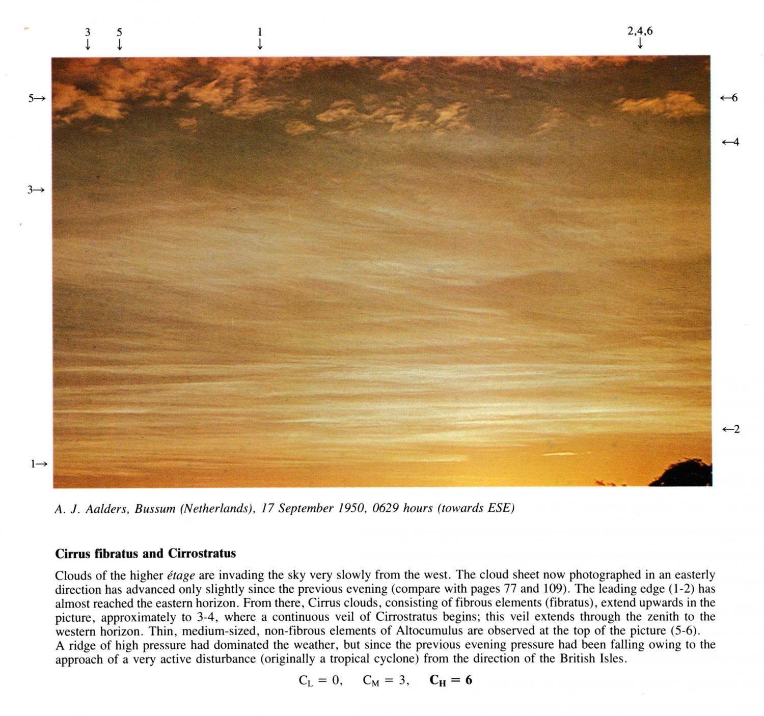
Cirrus fibratus and Cirrostratus
Clouds of the higher level are invading the sky very slowly from the west. The cloud sheet now photographed in an easterly direction has advanced only slightly since the previous evening (compare with image PR.79 and PR.113). The leading edge at 1 - 2 has almost reached the eastern horizon. From there, Cirrus clouds, consisting of fibrous elements (fibratus), extend upwards in the picture, approximately to 3 - 4, where a continuous veil of Cirrostratus begins; this veil extends through the zenith to the western horizon. Thin, medium-sized, non-fibrous elements of Altocumulus are observed at the top of the picture 5 - 6. A ridge of high pressure had dominated the weather, but since the previous evening pressure had been falling owing to the approach of a very active disturbance (originally a tropical cyclone) from the direction of the British Isles.
Links in the image description will highlight features on the image. Mouse over the features for more detail.
© A.J. AaldersBussum, NetherlandsLatitude: 52° 16' 26'' NLongitude: 5° 9' 59'' E17 September 1950 0629 (Local Time)Camera direction: towards ESECL = 0, CM = 3, CH = 6