© Kin Shing Ip
Wong Chuk Hang, Hong Kong, China
Latitude: 22° 14' 35'' N
Longitude: 114° 10' 20'' E
02 August 2015 1700 (Local Time)
Camera direction: towards S
Image P/S code: P.9.6
Image I.D.: 5740
CL = 2, CM = 8, CH = 3
-

Cumulus congestus pileus
Cumulus are detached clouds, generally dense and with sharp outlines, that develop vertically in the form of rising mounds, domes or towers; the sunlit parts are mostly brilliant white. They can be of great vertical extent and often develop into Cumulonimbus. In this image, the sproutings in the upper part of the cloud resemble a cauliflower, which identifies the species as congestus. This species usually develops from Cumulus mediocris. Sitting on top of the Cumulus tower is another small cloud resembling a cap or a hood. This is the accessory cloud pileus, which is often short-lived. Behind the tower is a patch of thick Cirrus of the species spissatus; it looks like a detached anvil and can be labelled cumulonimbogenitus. A layer of Stratocumulus cumulogenesis is also visible, while the white filaments of Cirrus fibratus can be seen near the top of the image.
Links in the image description will highlight features on the image. Mouse over the features for more detail.
© Kin Shing IpWong Chuk Hang, Hong Kong, ChinaLatitude: 22° 14' 35'' NLongitude: 114° 10' 20'' E02 August 2015 1700 (Local Time)Camera direction: towards SCL = 2, CM = 8, CH = 3Image P/S code: P.9.6Image I.D.: 5740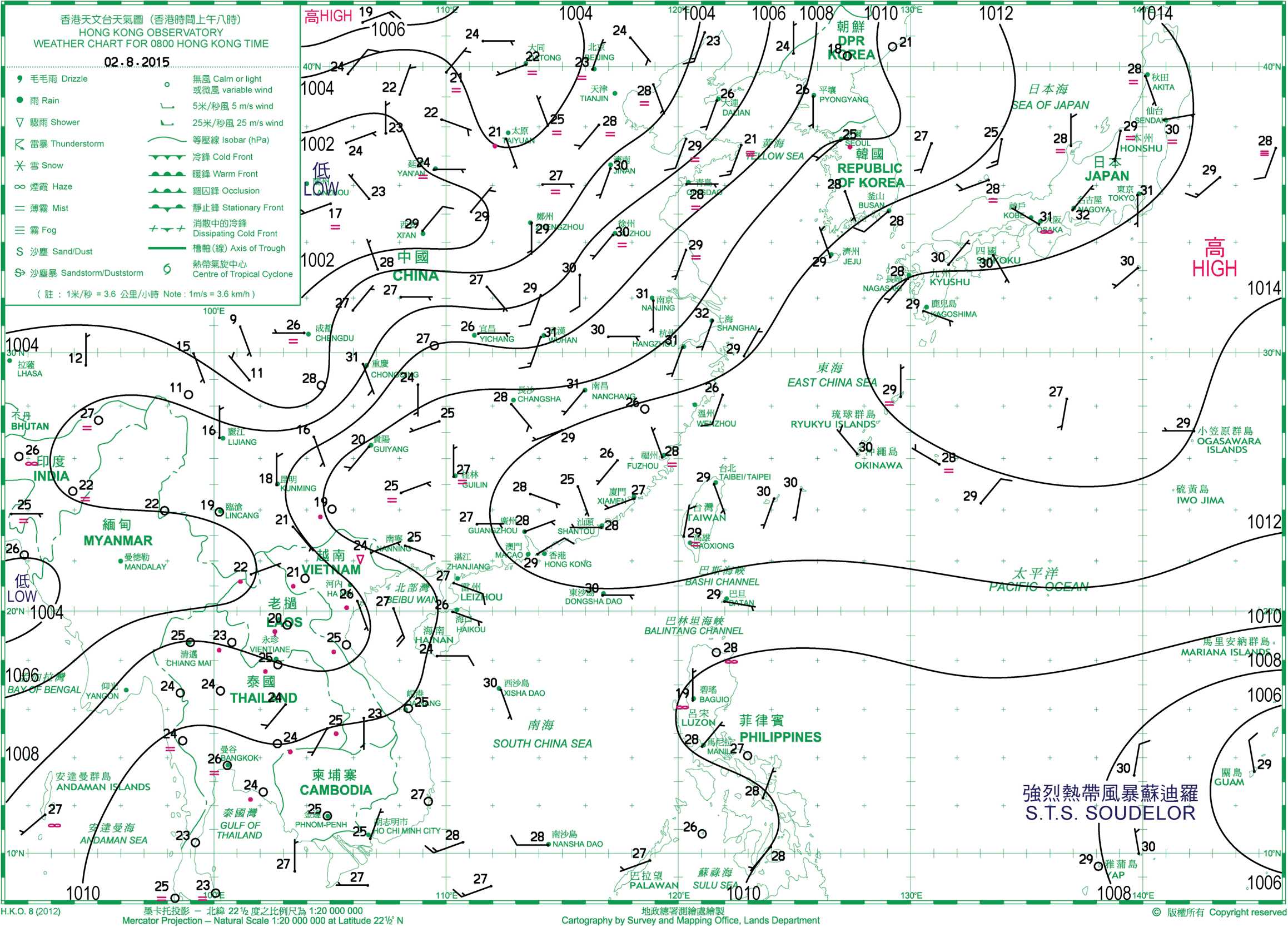
The 0800 hours local time chart shows a weak ridge over the south-east China coast, with a light easterly flow over Hong Kong (China).
© The Government of the Hong Kong Special Administrative Region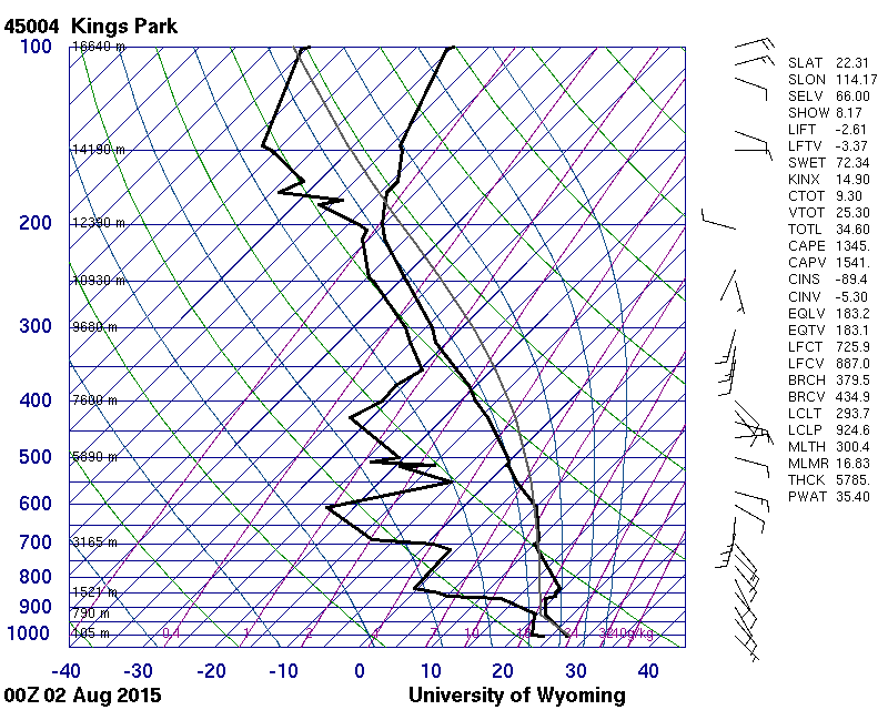
The Hong Kong (China) (WMO 45004) sounding, taken nine hours before the photograph, shows a conditionally unstable atmosphere, moist between 350 and 200 hPa (about 8 400 to 12 400 m) and characterized by light winds throughout.
© University of Wyoming
Cumulus congestus with pileus
This Cumulus cloud is strongly sprouting, has sharp outlines and is of moderate to great vertical extent, identifying it as species congestus. The bulging upper parts resemble a cauliflower at 1 and 2. The cap or hood in the centre is an accessory cloud pileus. Pileus is of small horizontal extent and can be above or attached to the main Cumulus cloud. Cumulus can penetrate through pileus and sometimes several pileus may be seen layered on top of one another. In this image, cloud tops to the left and right are losing their sharp outlines at 4 and 5, suggesting probable transition to becoming Cumulonimbus calvus.
Links in the image description will highlight features on the image. Mouse over the features for more detail.
© Anton van NiekerkMidrand, near Johannesburg, South AfricaLatitude: 25° 59' 22'' SLongitude: 28° 4' 4'' E16 December 2012 1738 (Local Time)Camera direction: towards SWCL = 2, CM = 3, CH = 0Image P/S code: S.9.6 1Image I.D.: 4737