© Hing Yim Mok
Downtown, Honolulu, HI, United States of America
Latitude: 21° 18' 25'' N
Longitude: 157° 51' 30'' W
29 June 2016 1206 (Local Time)
Camera direction: towards S
Image P/S code: P.4.5
Image I.D.: 5787
CL = 2, CM = 8, CH = 2
-
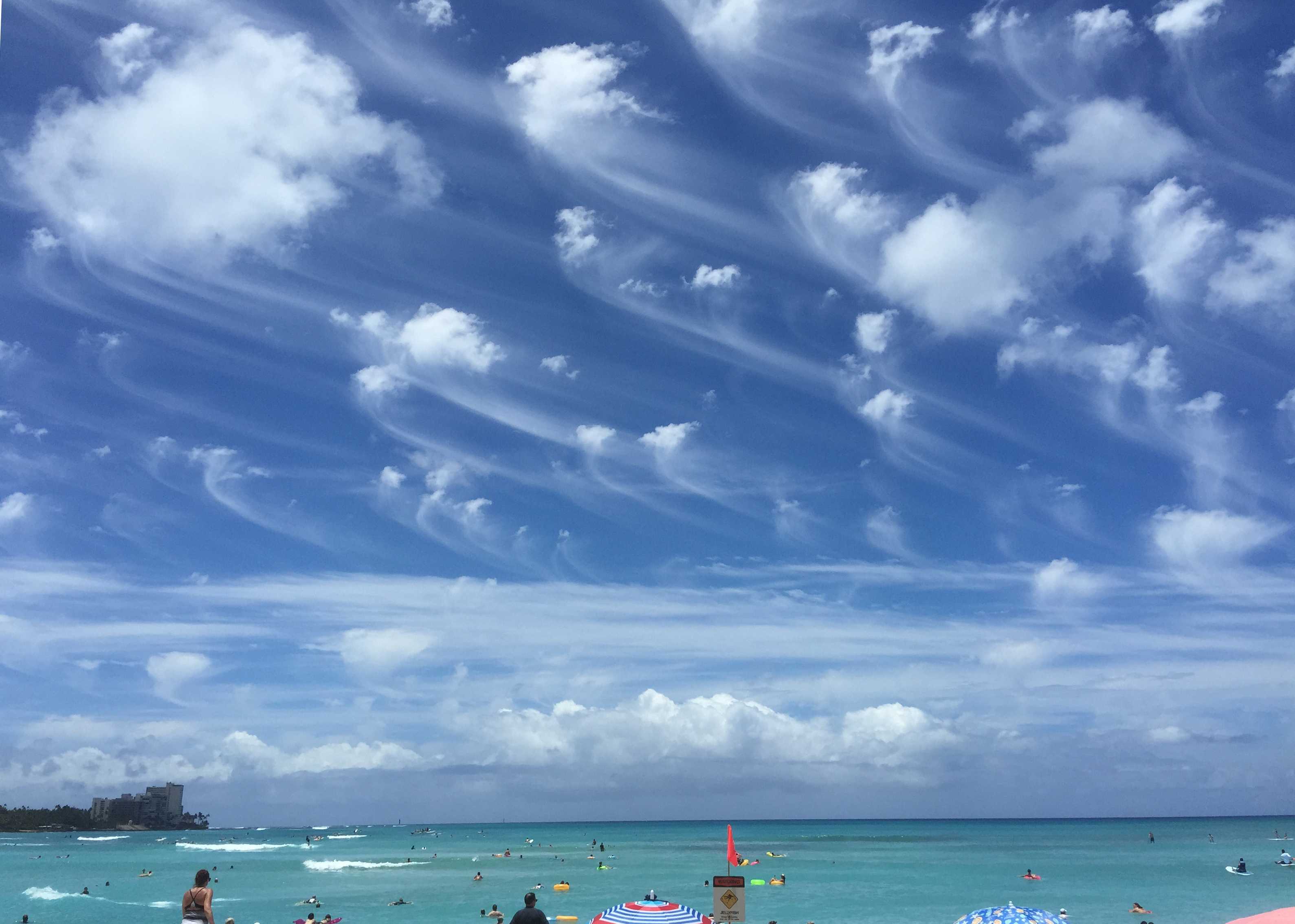
Altocumulus floccus virga
Low-level Cumulus, middle-level Altocumulus and high-level Cirrus feature in this image. Cumulus of moderate vertical extent (mediocris) is on the horizon.
The predominate cloud is Altocumulus floccus (with small cumuliform tufts), from which fibrous trails of ice crystal virga are falling. This cloud closely resembles Cirrus uncinus, but is not identified as such as the tufts are not fibrous and, on the whole, do not have a silky sheen.
There are several tufts of Altocumulus floccus that have evolved into Cirrus spissatus altocumulogenitus as they have frozen throughout.
Thick, long patches of Cirrus spisssatus complete the observation.
Links in the image description will highlight features on the image. Mouse over the features for more detail.
© Hing Yim MokDowntown, Honolulu, HI, United States of AmericaLatitude: 21° 18' 25'' NLongitude: 157° 51' 30'' W29 June 2016 1206 (Local Time)Camera direction: towards SCL = 2, CM = 8, CH = 2Image P/S code: P.4.5Image I.D.: 5787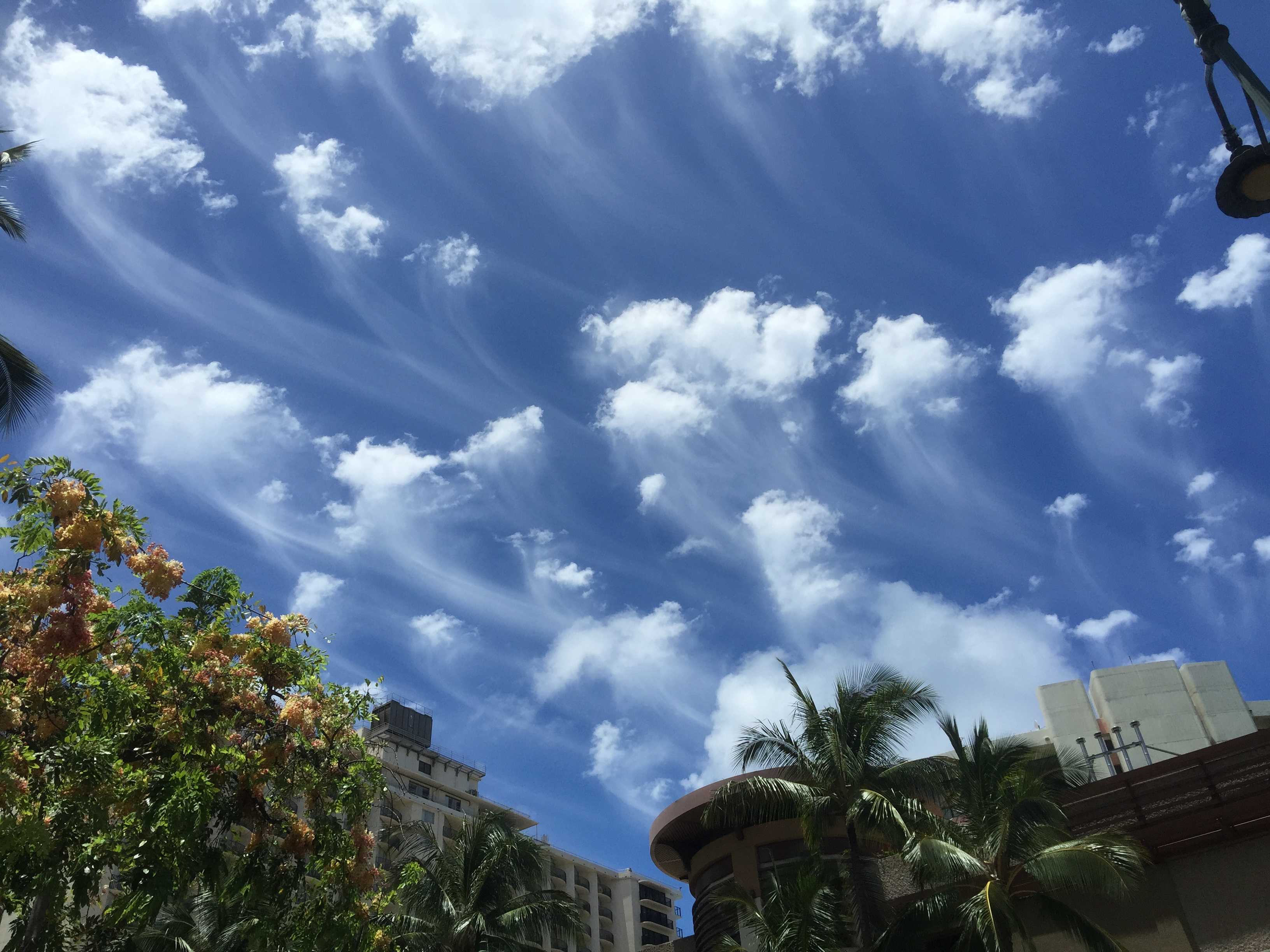
Altocumulus floccus virga
At first glance, this looks to be an Altocumulus floccus and Cirrus uncinus sky. However, all of the cloud is Altocumulus floccus (small cumuliform tufts) from which fibrous trails of ice crystal virga are falling. This observation is confirmed by the tufts neither being fibrous nor having a silky sheen.Links in the image description will highlight features on the image. Mouse over the features for more detail.
© Hing Yim MokDowntown, Honolulu, HI, United States of AmericaLatitude: 21° 18' 25'' NLongitude: 157° 51' 30'' W29 June 2016 1201 (Local Time)Camera direction: towards SCL = 0, CM = 8, CH = 0Image P/S code: P.4.5Image I.D.: 5788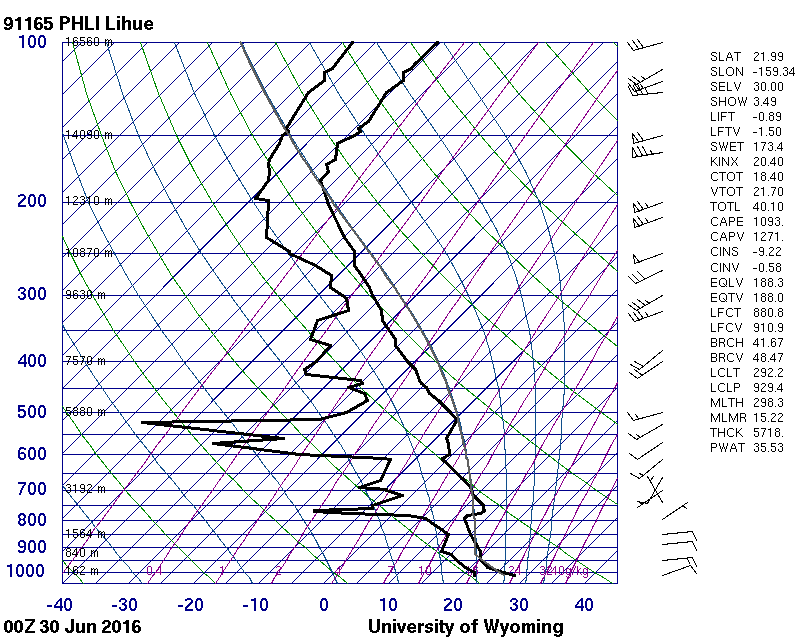
The sounding is inconclusive in establishing the height of the Altocumulus floccus. Reasonable moisture at 614 hPa is offset by a temperature of –0.7 °C, far too warm for such deep trails of ice crystal virga. The floccus is probably at 440 hPa (6 900 m), where the temperature is –15.7 °C. This height is within the WMO height range for the middle level in temperate and tropical zones.
© University of Wyoming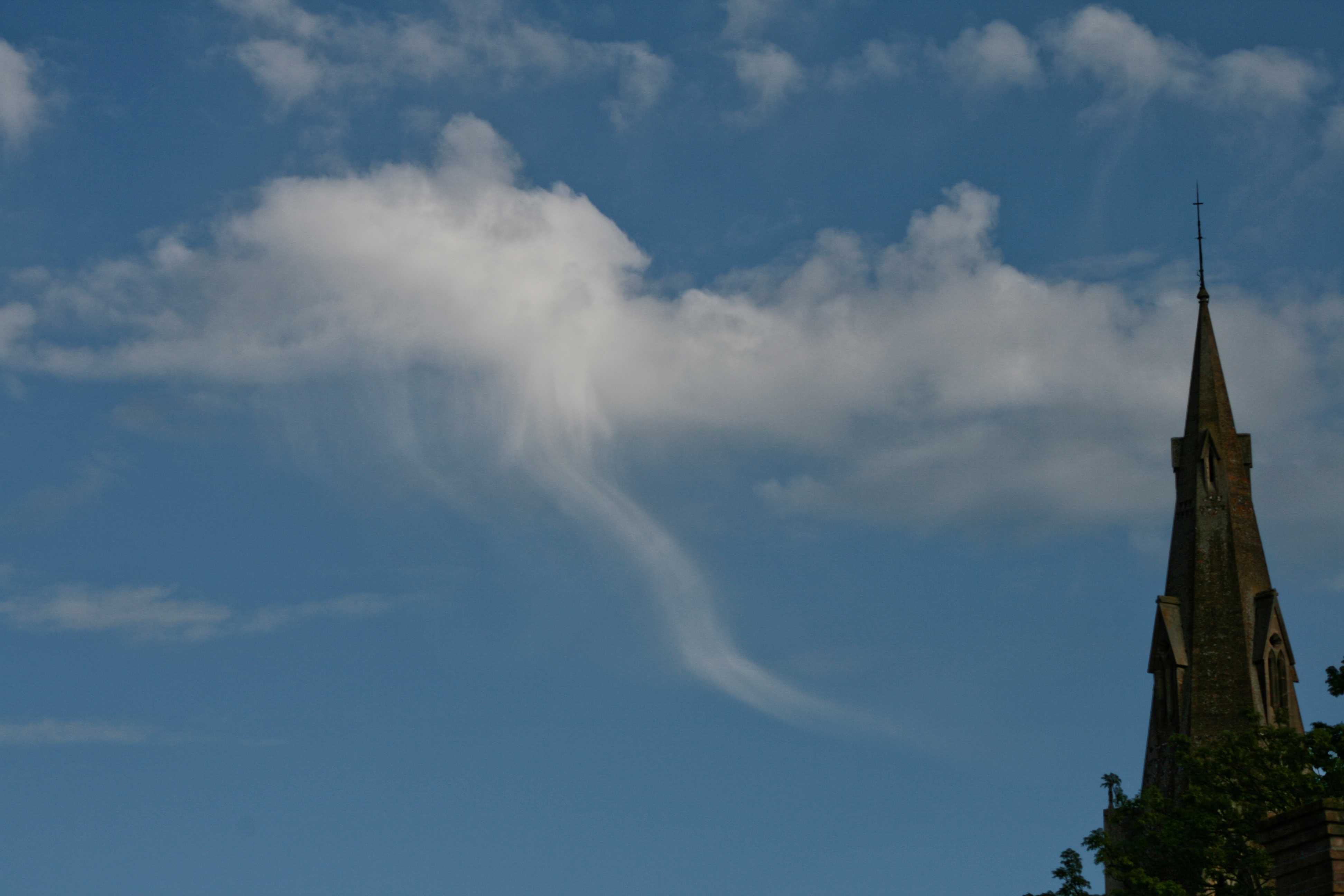
Altocumulus floccus with pronounced virga
The small tufts with ragged bases at the top of the picture are Altocumulus floccus. Fibrous trails of ice crystal virga are falling from the floccus tufts on the southern (right) side.
The larger cumuliform masses to the left of the church spire are Altocumulus castellanus, evolving into floccus as a result of the dissipation of the castellanus bases.
There is a striking example of ice crystal virga falling from the largest cell. The cell is still identified as Altocumulus as most of the tuft does not have a fibrous appearance or silky sheen.
Links in the image description will highlight features on the image. Mouse over the features for more detail.
© Stephen BurtStratfield Mortimer, near Reading, Berkshire RG7, United Kingdom of Great Britain and Northern IrelandLatitude: 51° 22' 12'' NLongitude: 1° 2' 24'' W20 May 2009 1650 (Local Time)Camera direction: towards SECL = 0, CM = 8, CH = 0Image P/S code: S.4.5 4Image I.D.: 5926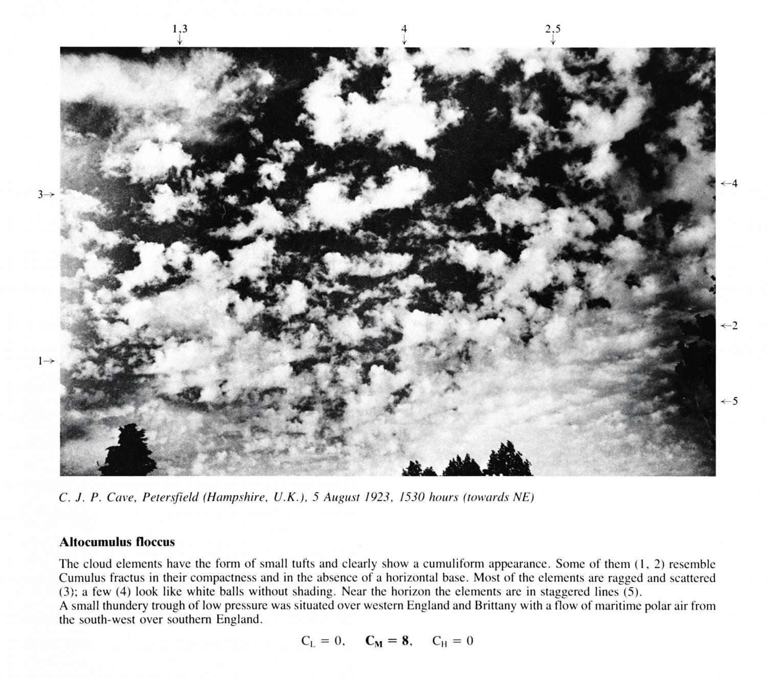
Altocumulus floccus
The cloud elements have the form of small tufts and clearly show a cumuliform appearance. Some of them (1, 2) resemble Cumulus fractus in their compactness and in the absence of a horizontal base. Most of the elements are ragged and scattered (3); a few (4) look like white balls without shading. Near the horizon the elements are in staggered lines (5). A small thundery trough of low pressure was situated over western England and Brittany with a flow of maritime polar air from the south-west over southern England.
Links in the image description will highlight features on the image. Mouse over the features for more detail.
© C.J.P. CavePetersfield, Hampshire, United Kingdom of Great Britain and Northern IrelandLatitude: 51° 0' 27'' NLongitude: 0° 56' 20'' W05 August 1923 1530 (Local Time)Camera direction: towards NECL = 0, CM = 8, CH = 0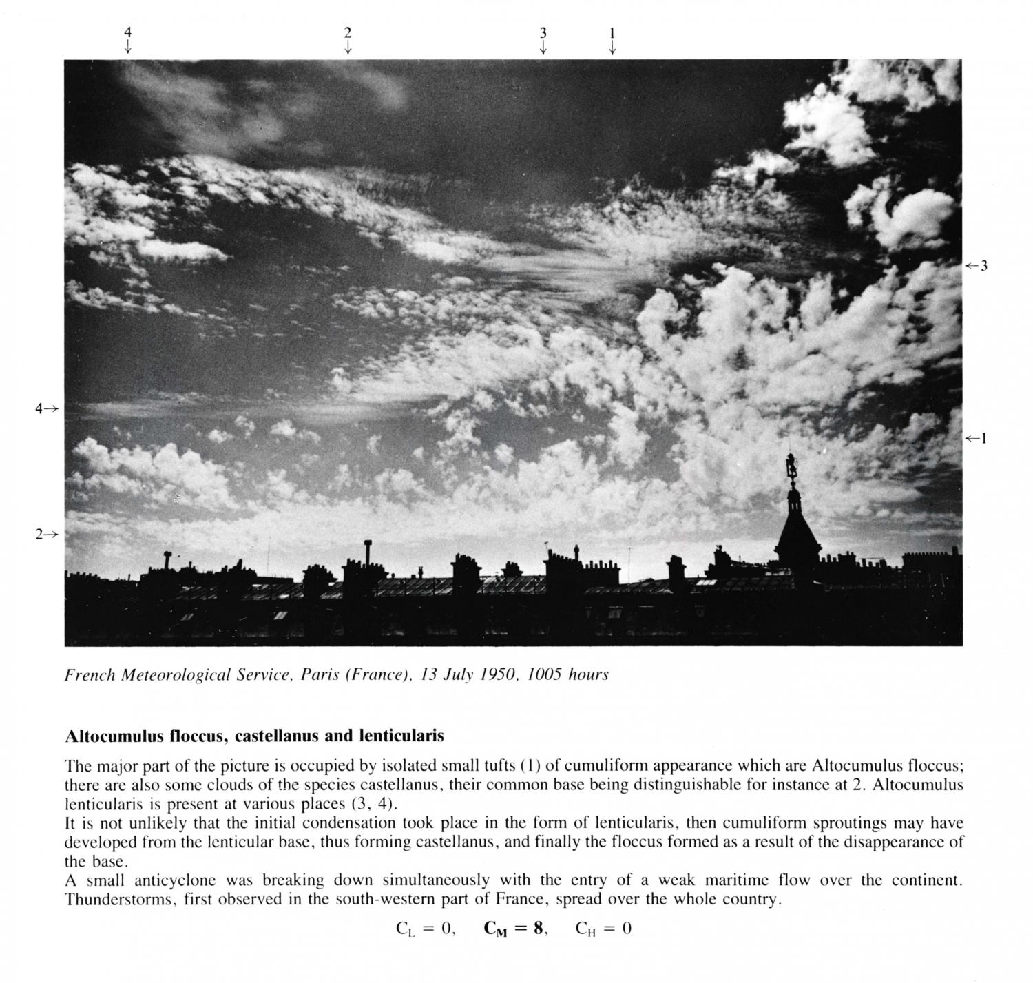
Altocumulus floccus, castellanus and lenticularis
The major part of the picture is occupied by isolated small tufts of cumuliform appearance which are Altocumulus floccus: there are also some clouds of the species castellanus, their common base being distinguishable for instance at 2. Altocumulus lenticularis is present at various places (3, 4). It is not unlikely that the initial condensation took place in the form of lenticularis, then cumuliform sproutings may have developed from the lenticular base, thus forming castellanus, and finally the floccus formed as a result of the disappearance of the base. A small anticyclone was breaking down simultaneously with the entry of a weak maritime flow over the continent. Thunderstorms, first observed in the south-western part of France, spread over the whole country.
Links in the image description will highlight features on the image. Mouse over the features for more detail.
© French Meteorological ServiceParis, FranceLatitude: 48° 51' 24'' NLongitude: 2° 21' 8'' E13 July 1950 1005 (Local Time)CL = 0, CM = 8, CH = 0